
Palmarejo, Corozal, Puerto Rico facts for kids
Quick facts for kids
Palmarejo
|
|
|---|---|
|
Barrio
|
|

Plantain cultivation in Palmarejo
|
|

Location of Palmarejo within the municipality of Corozal shown in red
|
|

Palmarejo, Corozal, Puerto Rico
Location in Caribbean
|
|
| Commonwealth | |
| Municipality | |
| Area | |
| • Total | 3.86 sq mi (10.0 km2) |
| • Land | 3.86 sq mi (10.0 km2) |
| • Water | 0 sq mi (0 km2) |
| Elevation | 735 ft (224 m) |
| Population
(2010)
|
|
| • Total | 6,068 |
| • Density | 1,572/sq mi (607/km2) |
| Source: 2010 Census | |
| Time zone | UTC−4 (AST) |
Palmarejo is a special kind of neighborhood, called a barrio, located in the town of Corozal, Puerto Rico. It's mostly a countryside area, but it also has a small town part. In 2010, about 6,068 people lived there.
Contents
A Glimpse into Palmarejo's Past
Palmarejo was first mentioned in official Spanish records, known as gazetteers. This was before Puerto Rico became part of the United States. After the Spanish–American War in 1898, Spain gave Puerto Rico to the United States. This happened under an agreement called the Treaty of Paris of 1898.
Puerto Rico then became an unincorporated territory of the U.S. This means it's a territory that belongs to the U.S. but is not fully part of it, like a state. In 1899, the U.S. government took a count of all the people in Puerto Rico, called a census. They found that 901 people lived in Palmarejo barrio at that time.
Palmarejo's Size and Population
Palmarejo covers an area of about 3.86 square miles (about 10 square kilometers) of land. It doesn't have any water areas within its borders. In 2010, the population was 6,068 people. This means there were about 1,572 people living in each square mile. This is called the population density.
| Historical population | |||
|---|---|---|---|
| Census | Pop. | %± | |
| 1900 | 901 | — | |
| 1910 | 1,182 | 31.2% | |
| 1920 | 1,177 | −0.4% | |
| 1930 | 1,505 | 27.9% | |
| 1940 | 1,954 | 29.8% | |
| 1950 | 2,414 | 23.5% | |
| 1980 | 3,985 | — | |
| 1990 | 5,299 | 33.0% | |
| 2000 | 5,856 | 10.5% | |
| U.S. Decennial Census 1899 (shown as 1900) 1910-1930 1930-1950 1980-2000 2010 |
|||
The main road that goes through Palmarejo from east to west is PR-164.
-
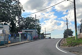
Puerto Rico Highway 803 in Palmarejo
.jpg)
The Historic Mavilla Bridge
There's a special bridge called the Mavilla Bridge that connects Palmarejo barrio with another barrio in Corozal called Abras. This bridge is so important that it's listed on the National Register of Historic Places in Puerto Rico.
-
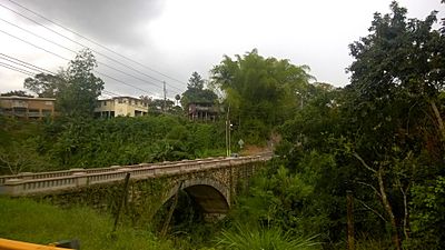
Mavilla Bridge (Ca. 2015)

Smaller Areas: Sectors of Palmarejo
Barrios like Palmarejo are often divided into even smaller local areas. These smaller areas are called sectores (which means sectors in English). The names for these sectors can be different. Some are just called sector, while others might be called urbanización, reparto, barriada, or residencial.
Here are some of the sectors you can find in Palmarejo barrio:
- Barriada Decene
- Calle Juana Santiago
- Parcelas Guarico
- Parcelas Julián Marrero
- Sector Alejo Rosado
- Sector Alturas de Corozal
- Sector Chary
- Sector Cheo Marrero
- Sector Club de Leones
- Sector Corozal Hills
- Sector Cuchillas
- Sector Dolores Cosme
- Sector El Convento
- Sector El Picuíto
- Sector El Pomito
- Sector El Rancho
- Sector Félix Padilla
- Sector Guarico
- Sector Juana Santiago
- Sector La Buruquena
- Sector La Gallera
- Sector La Mina
- Sector Los Fonseca
- Sector Los Llanos
- Sector Los Negrones
- Sector Los Nieves (from cemetery to La Gallera)
- Sector Los Panzardi
- Sector Los Rojas
- Sector Luis Collazo
- Sector Marrero
- Sector Pancho Febus
- Sector Pomo Rodríguez
- Sector Tom Rolón
- Sector Toño Patente
- Urbanización Estancias de Palmarejo
- Urbanización Los Policías
- Urbanización María del Carmen
See also
 In Spanish: Palmarejo (Corozal) para niños
- List of communities in Puerto Rico
- List of barrios and sectors of Corozal, Puerto Rico
