Cuchillas, Corozal, Puerto Rico facts for kids
Quick facts for kids
Cuchillas
|
|
|---|---|
|
Barrio
|
|

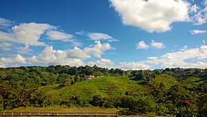
A home in the hills of Cuchillas
|
|

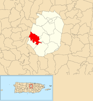
Location of Cuchillas within the municipality of Corozal shown in red
|
|
| Lua error in Module:Location_map at line 416: Malformed coordinates value. | |
| Commonwealth | |
| Municipality | |
| Area | |
| • Total | 2.69 sq mi (7.0 km2) |
| • Land | 2.69 sq mi (7.0 km2) |
| • Water | 0 sq mi (0 km2) |
| Elevation | 1,549 ft (472 m) |
| Population
(2010)
|
|
| • Total | 1,551 |
| • Density | 576.6/sq mi (222.6/km2) |
| Source: 2010 Census | |
| Time zone | UTC−4 (AST) |
Cuchillas is a quiet, rural barrio (which is like a neighborhood or district) in the municipality of Corozal, Puerto Rico. It is a peaceful place with natural beauty. In 2010, about 1,551 people called Cuchillas home.
Contents
A Look Back in Time
Cuchillas has a history that goes back many years. It was once part of Spain. After the Spanish–American War in 1898, Puerto Rico became a territory of the United States. This happened because of a peace agreement called the Treaty of Paris of 1898.
In 1899, the United States government counted the people living in Puerto Rico. They found that 585 people lived in Cuchillas at that time.
Where is Cuchillas Located?
Cuchillas is found in the northwestern part of the Corozal municipality. It shares its borders with several other barrios of Corozal. These include Padilla, Negros, Palmarito, and Magueyes.
Cuchillas also touches the border of another barrio named Cuchillas in the nearby Morovis municipality. The Río Grande de Manatí river flows along the southern edge of Cuchillas. This river meets the Orocovis River in this area.
Facts and Figures About Cuchillas
Cuchillas covers an area of about 2.69 square miles (about 7 square kilometers) of land. It does not have any large bodies of water within its borders.
In 2010, the population of Cuchillas was 1,551 people. This means that about 576 people lived in every square mile. This number is called the population density. It helps us understand how crowded or spread out people are in an area.
Population Growth Over the Years
The number of people living in Cuchillas has changed over time. Here's how the population has grown or changed based on official counts:
| Historical population | |||
|---|---|---|---|
| Census | Pop. | %± | |
| 1900 | 585 | — | |
| 1910 | 752 | 28.5% | |
| 1920 | 700 | −6.9% | |
| 1930 | 971 | 38.7% | |
| 1940 | 1,139 | 17.3% | |
| 1950 | 1,300 | 14.1% | |
| 1980 | 1,167 | — | |
| 1990 | 1,213 | 3.9% | |
| 2000 | 1,393 | 14.8% | |
| 2010 | 1,551 | 11.3% | |
| U.S. Decennial Census 1899 (shown as 1900) 1910-1930 1930-1950 1980-2000 2010 |
|||
Smaller Areas: Sectors
In Puerto Rico, barrios like Cuchillas are often divided into even smaller local areas. These smaller areas are called sectores (which means sectors in English). There are different types of sectores, like urbanización (urbanization), reparto (development), or barriada (neighborhood).
Here are some of the sectores you can find in Cuchillas:
- Sector Berio
- Sector Car Wash
- Sector Collazo
- Sector Guayabo
- Sector Hormigas II
- Sector La Pajona
- Sector Los Cocos
- Sector Los Indios
- Sector Los Rosado
- Sector Millo Santiago
- Sector Siquín Morales
- Sector Tivo Vázquez
- Sector Toñito Santiago
See also
 In Spanish: Cuchillas (Corozal) para niños
- List of communities in Puerto Rico
- List of barrios and sectors of Corozal, Puerto Rico
 | Lonnie Johnson |
 | Granville Woods |
 | Lewis Howard Latimer |
 | James West |

