
Palmarito facts for kids
Quick facts for kids
Palmarito
|
|
|---|---|
|
Barrio
|
|

A view of Palmarito from Negros in Corozal
|
|

Location of Palmarito within the municipality of Corozal shown in red
|
|

Palmarito
Location in Caribbean
|
|
| Commonwealth | |
| Municipality | |
| Area | |
| • Total | 4.93 sq mi (12.8 km2) |
| • Land | 4.93 sq mi (12.8 km2) |
| • Water | 0 sq mi (0 km2) |
| Elevation | 1,982 ft (604 m) |
| Population
(2010)
|
|
| • Total | 2,227 |
| • Density | 451.7/sq mi (174.4/km2) |
| Source: 2010 Census | |
| Time zone | UTC−4 (AST) |
Palmarito is a quiet, countryside area, also known as a barrio, located in the town of Corozal, Puerto Rico. In 2010, about 2,227 people lived here. It's a place where you can find beautiful views and a peaceful way of life.
Contents
A Glimpse into Palmarito's Past
How Palmarito Became Part of the U.S.
Palmarito has a long history. It was once listed in official Spanish records. After the Spanish–American War in 1898, Spain gave Puerto Rico to the United States. This happened because of a peace agreement called the Treaty of Paris of 1898. From then on, Puerto Rico became a territory of the United States.
Early Population Counts
In 1899, the United States government took a count of all the people in Puerto Rico. This count is called a census. The census found that 770 people lived in Palmarito barrio at that time.
Palmarito's Size and Population
Land Area and Water
Palmarito covers about 4.93 square miles of land. That's roughly the size of 3,155 football fields! It doesn't have any large bodies of water within its area.
How Many People Live Here?
In 2010, the population of Palmarito was 2,227 people. This means that about 451 people lived in every square mile. This number helps us understand how crowded or spread out a place is.
| Historical population | |||
|---|---|---|---|
| Census | Pop. | %± | |
| 1900 | 770 | — | |
| 1910 | 1,187 | 54.2% | |
| 1920 | 1,241 | 4.5% | |
| 1930 | 1,336 | 7.7% | |
| 1940 | 1,696 | 26.9% | |
| 1950 | 1,995 | 17.6% | |
| 1980 | 1,944 | — | |
| 1990 | 1,902 | −2.2% | |
| 2000 | 2,160 | 13.6% | |
| U.S. Decennial Census 1899 (shown as 1900) 1910-1930 1930-1950 1980-2000 2010 |
|||
Understanding Palmarito's Sections
What are Barrios and Sectors?
In Puerto Rico, a barrio is like a neighborhood or a district. These barrios are then divided into even smaller areas called sectores (which means sectors in English). Think of it like a big puzzle, where the barrio is a large piece, and the sectores are the smaller pieces that fit together to make it up. These sectors can have different names like urbanización (a type of housing development) or reparto (another type of division).
Main Sectors in Palmarito
The Palmarito barrio is made up of several smaller sectors. Here are some of them:
Palmarito Area
- Parcelas Berio Nuevas
- Parcelas Berio Viejas
- Sector Albaladejo
- Sector Chago Torres
- Sector Che Díaz
- Sector Eduardo Rivera
- Sector El Riachuelo
- Sector Félix Padilla
- Sector Finito Santiago
- Sector Frank Ortiz
- Sector Geño Rivera
- Sector Goyo Torres
- Sector Los Molina
- Sector Pifio Rivera
- Sector Pimo Ortiz
- Urbanización Estancias de la Montaña
Palmarito Central Area
- Sector El Cuatro
- Sector El Perico (La PRA)
- Sector Finín Lozada
- Sector La Gallera
- Sector Los Montesino
- Sector Los Peña
- Sector Marciano Burgos
- Sector Radio Oro (La Emisora)
Gallery
-
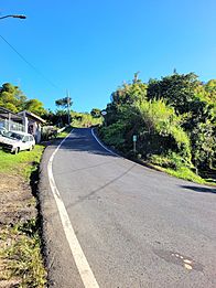
Puerto Rico Highway 800 in Palmarito
-
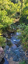
Quebrada Riachuelo in Palmarito


See also
 In Spanish: Palmarito (Corozal) para niños
- List of communities in Puerto Rico
- List of barrios and sectors of Corozal, Puerto Rico
