Dos Bocas, Corozal, Puerto Rico facts for kids
Quick facts for kids
Dos Bocas
|
|
|---|---|
|
Barrio
|
|

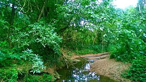
Río de los Negros in Dos Bocas
|
|

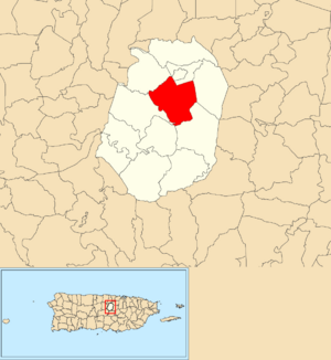
Location of Dos Bocas within the municipality of Corozal shown in red
|
|
| Commonwealth | |
| Municipality | |
| Area | |
| • Total | 4.06 sq mi (10.5 km2) |
| • Land | 4.06 sq mi (10.5 km2) |
| • Water | 0 sq mi (0 km2) |
| Elevation | 512 ft (156 m) |
| Population
(2010)
|
|
| • Total | 3,060 |
| • Density | 753.7/sq mi (291.0/km2) |
| Source: 2010 Census | |
| Time zone | UTC−4 (AST) |
Dos Bocas is a small, mostly rural area, also called a barrio, located in the town of Corozal, Puerto Rico. It's a part of Puerto Rico, which is an island territory of the United States. In 2010, about 3,060 people lived in Dos Bocas.
Contents
A Look Back: The History of Dos Bocas
For a long time, Dos Bocas was listed in official Spanish records. This was before Puerto Rico became a part of the United States.
After the Spanish–American War, Spain gave Puerto Rico to the United States. This happened because of an agreement called the Treaty of Paris of 1898. Puerto Rico then became an unincorporated territory of the United States. This means it's a U.S. territory but not a state.
In 1899, the United States Department of War counted everyone living in Puerto Rico. This count is called a census. The census found that 909 people lived in the Dos Bocas barrio at that time.
Exploring Dos Bocas: Land and People
Dos Bocas covers about 4.06 square miles (about 10.5 square kilometers) of land. It does not have any large bodies of water.
In 2010, the population of Dos Bocas was 3,060 people. This means there were about 753.7 people living in each square mile. This number is called the population density.
| Historical population | |||
|---|---|---|---|
| Census | Pop. | %± | |
| 1900 | 909 | — | |
| 1910 | 1,005 | 10.6% | |
| 1920 | 1,124 | 11.8% | |
| 1930 | 1,275 | 13.4% | |
| 1940 | 1,447 | 13.5% | |
| 1950 | 1,890 | 30.6% | |
| 1980 | 2,172 | — | |
| 1990 | 2,640 | 21.5% | |
| 2000 | 2,760 | 4.5% | |
| U.S. Decennial Census 1899 (shown as 1900) 1910-1930 1930-1950 1980-2000 2010 |
|||
The main road that goes through Dos Bocas from north to south is PR-807.
Dos Bocas: Its Smaller Areas
Barrios in Puerto Rico are like larger neighborhoods or divisions within a town. These barrios are then divided into even smaller local areas. These smaller areas are called sectores (which means sectors in English).
There are different types of sectores. Some are simply called sector, while others might be called urbanización (a planned housing area), reparto (a land division), barriada (a neighborhood), or residencial (a residential complex).
Here are some of the sectors you can find in Dos Bocas barrio:
- Calle Leoncito Ortiz
- Parcelas Ortiz
- Sector Ángel Vázquez
- Sector Benjamín González
- Sector Bernardo Padilla
- Sector Caldero
- Sector Carmelo Ortiz (Los Batatos)
- Sector Carretera (from Dos Bocas entrance to Sector Mingo Díaz)
- Sector Daniel Negrón
- Sector El Faro
- Sector El Quinto
- Sector El Típico
- Sector Honduras
- Sector Julio Vázquez
- Sector La Mina
- Sector La Santa
- Sector Leoncito Ortíz
- Sector Los García
- Sector Los Maldonado
- Sector Los Marrero
- Sector Los Miranda
- Sector Mingo Díaz
- Sector Moncho Santos
- Sector Neco Chévere
- Sector Sioso Virella
- Urbanización Loma Linda
- Urbanización San Francisco
See also
 In Spanish: Dos Bocas (Corozal) para niños
- List of communities in Puerto Rico
- List of barrios and sectors of Corozal, Puerto Rico
 | Valerie Thomas |
 | Frederick McKinley Jones |
 | George Edward Alcorn Jr. |
 | Thomas Mensah |


