
Corozal barrio-pueblo facts for kids
Quick facts for kids
Corozal barrio-pueblo
Pueblo de Corozal
|
|
|---|---|
|
Municipality Seat
|
|

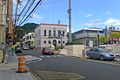
View of Corozal barrio-pueblo from Abras
|
|

Location of Corozal barrio-pueblo within the municipality of Corozal shown in red
|
|

Corozal barrio-pueblo
Location in Caribbean
|
|
| Commonwealth | |
| Municipality | |
| Area | |
| • Total | .352 sq mi (0.91 km2) |
| • Land | .352 sq mi (0.91 km2) |
| • Water | 0 sq mi (0 km2) |
| Elevation | 262 ft (80 m) |
| Population
(2010)
|
|
| • Total | 2,631 |
| • Density | 7,517.1/sq mi (2,902.4/km2) |
| Source: 2010 Census | |
| Time zone | UTC−4 (AST) |
Corozal barrio-pueblo is a special part of Corozal. It's like the main town center, where the local government is. In 2010, about 2,631 people lived here.
In Puerto Rico, like in Spain, each town has a "pueblo" area. This area usually has a main square, the town hall, and a Catholic church. People often gather in the main square for fun events and festivals throughout the year.
Contents
History of Corozal Pueblo
Corozal barrio-pueblo was part of Spain for a long time. After the Spanish–American War in 1898, Puerto Rico became a territory of the United States. This happened because of a peace agreement called the Treaty of Paris of 1898.
In 1899, the United States counted the people in Puerto Rico. They found that 1,057 people lived in Corozal barrio-pueblo at that time.
Facts and Figures
Corozal barrio-pueblo covers about 0.352 square miles of land. It does not have any water areas. In 2010, the population was 2,631 people. This means there were about 7,517 people living in each square mile.
Here's how the population of Corozal barrio-pueblo has changed over the years:
| Historical population | |||
|---|---|---|---|
| Census | Pop. | %± | |
| 1900 | 1,057 | — | |
| 1910 | 1,301 | 23.1% | |
| 1920 | 1,747 | 34.3% | |
| 1930 | 2,451 | 40.3% | |
| 1940 | 2,974 | 21.3% | |
| 1950 | 2,428 | −18.4% | |
| 1980 | 1,663 | — | |
| 1990 | 3,011 | 81.1% | |
| 2000 | 2,850 | −5.3% | |
| U.S. Decennial Census 1899 (shown as 1900) 1910-1930 1930-1950 1980-2000 2010 |
|||
The Main Square and Church
The main square, or plaza, is a very important place in Corozal barrio-pueblo. It's where people meet up, relax, and enjoy community events. Old Spanish laws from the 1800s said that these squares should be big enough for all the people living nearby. They also said that the streets around the square should have covered walkways. These walkways would protect people from the sun and rain.
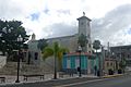
Right across from the main square in Corozal barrio-pueblo is a Roman Catholic church. It is called Parroquia La Sagrada Familia.
Local Areas (Sectors)
Barrios are often divided into smaller local areas. These smaller areas are called sectores (which means "sectors" in English). There are different types of sectors. Some are just called "sector," while others might be called "urbanización" or "barriada."
Here are some of the sectors you can find in Corozal barrio-pueblo:
- Barriada Aldea Vázquez
- Barriada Bou
- Calle Carmelo Aponte
- Calle Cervantes
- Calle Colegio Católico
- Calle Culto
- Calle Gándara
- Calle Genaro Bou
- Calle Howard T. Jason
- Calle José Valiente
- Calle La Marina
- Calle Las Mercedes
- Calle Nueva
- Calle San Manuel
- Calle Urbano Ramírez
- Calle Santo Domingo
- Calle Sostre
- Calle San Ramón
- Desvío Urbano
- Extensión Sobrino
- Residencial El Centro
- Residencial Enrique Landrón
- Sector Alcantarilla
- Sector Alfonso Matos
- Sector Cantera
- Sector Portugués
- Urbanización Sanfeliz
- Urbanización Sobrino
Gallery
-
Central plaza or square in Corozal pueblo
-
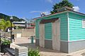
Museo de la Barbería Barber museum
-
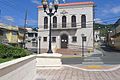
Town hall in Corozal, in front of central plaza
-
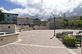
Square in Corozal pueblo
-
Buildings around the square
-
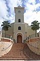
Parroquia La Sagrada Familia in Corozal pueblo
.jpg)
.jpg)
.jpg)
.jpg)

.jpg)
See also
 In Spanish: Corozal (Corozal) para niños
- List of communities in Puerto Rico
- List of barrios and sectors of Corozal, Puerto Rico
