
Cibuco, Corozal, Puerto Rico facts for kids
Quick facts for kids
Cibuco
|
|
|---|---|
|
Barrio
|
|

Plantain cultivation in Cibuco barrio
|
|

Location of Cibuco within the municipality of Corozal shown in red
|
|

Cibuco, Corozal, Puerto Rico
Location in Caribbean
|
|
| Commonwealth | |
| Municipality | |
| Area | |
| • Total | 3.6 sq mi (9 km2) |
| • Land | 3.6 sq mi (9 km2) |
| • Water | 0 sq mi (0 km2) |
| Elevation | 312 ft (95 m) |
| Population
(2010)
|
|
| • Total | 5,387 |
| • Density | 1,504.7/sq mi (581.0/km2) |
| Source: 2010 Census | |
| Time zone | UTC−4 (AST) |
Cibuco is a special kind of neighborhood, called a barrio, located in the town of Corozal, Puerto Rico. It's mostly a rural area, meaning it has a lot of open land and farms, but it also has a small urban (city-like) part. In 2010, about 5,387 people lived in Cibuco.
Contents
A Look Back: Cibuco's History
Cibuco was once part of Spain and was listed in their official records. This changed after the Spanish–American War in 1898. Following this war, Puerto Rico became a territory of the United States.
In 1899, the United States government took a count of all the people in Puerto Rico, which is called a census. This first census showed that 1,098 people lived in Cibuco barrio at that time.
Cibuco's Land and People
Cibuco covers an area of about 3.6 square miles (about 9.3 square kilometers) of land. It doesn't have any large bodies of water within its borders.
In 2010, the population of Cibuco was 5,387 people. This means there were about 1,504 people living in each square mile.
| Historical population | |||
|---|---|---|---|
| Census | Pop. | %± | |
| 1900 | 1,096 | — | |
| 1910 | 1,126 | 2.7% | |
| 1920 | 1,250 | 11.0% | |
| 1930 | 1,708 | 36.6% | |
| 1940 | 2,030 | 18.9% | |
| 1950 | 2,023 | −0.3% | |
| 1980 | 3,451 | — | |
| 1990 | 4,264 | 23.6% | |
| 2000 | 5,054 | 18.5% | |
| U.S. Decennial Census 1899 (shown as 1900) 1910-1930 1930-1950 1980-2000 2010 |
|||
Exploring Cibuco's Smaller Areas: Sectors
Barrios like Cibuco are often divided into even smaller local areas. These smaller parts are called sectores (which means sectors in English).
The names of these sectors can be different. Some are simply called "sector," while others might be named "urbanización" (a type of housing development), "reparto," "barriada," or "residencial."
Here are the different sectors you can find within Cibuco barrio:
Cibuco 1: Neighborhoods and Communities
This part of Cibuco includes several smaller areas. You'll find:
- Sector Academia
- Sector Aníbal Cabranes
- Sector Baja del Palo
- Sector Boina
- Sector Geño Trinidad
- Sector La Escuela
- Sector Los Crespo
- Sector Los Puertos
- Sector Los Torres
- Sector Los Trinidad
- Sector Maguayo
- Sector Mingo Negrón
- Sector Nela Nevárez
- Sector Tomás Colón
- Urbanización Estancias de Cibuco
- Urbanización Los Próceres
- Urbanización Villas de Cibuco
Cibuco 2: More Local Areas
This section of Cibuco has its own unique areas, such as:
- Extensión Sylvia
- Sector Acueducto
- Sector Empalme
- Sector Guevara
- Sector Julio Ortega
- Sector Korea
- Sector La Mina
- Sector Layo Rosado
- Sector Los Mangoes
- Sector Los Pacheco
- Sector Millo Maldonado
- Sector Monte de las Brujas
- Sector Pepe Pizza
- Sector Rolo Barrera
- Urbanización Alturas de Cibuco
- Urbanización Cibuco
- Urbanización Colinas de Corozal
- Urbanización Sylvia
Cibuco 3: Additional Subdivisions
The third part of Cibuco contains these areas:
- Sector El Vironay
- Sector Juan Vázquez
- Sector Lin Pérez
- Urbanización Valle de Aramaná
- Urbanización Villas de Monte Verde
Images for kids
-
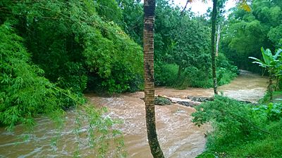
The Cibuco River flowing through Cibuco barrio on a rainy day.

See also
 In Spanish: Cibuco (Corozal) para niños
- List of communities in Puerto Rico
- List of barrios and sectors of Corozal, Puerto Rico
