
Hatillo, Puerto Rico facts for kids
Quick facts for kids
Hatillo
Municipio de Hatillo
|
|||
|---|---|---|---|
|
Town and Municipality
|
|||

Sunset over La Marina in Hatillo
|
|||
|
|||
| Nicknames:
"El Pueblo sin Sopa", "Capital De La Industria Lechera"' "Hatillo Del Corazón De Riego", "Tierra de Campos Verdes", "Los Ganaderos"
|
|||
| Anthem: "De un mar azul en el Atlántico" | |||

Map of Puerto Rico highlighting Hatillo Municipality
|
|||
| Sovereign state | |||
| Commonwealth | |||
| Founded | June 30, 1823 | ||
| Founded by | Agustín Ruiz Miranda | ||
| Barrios |
10 barrios
|
||
| Area | |||
| • Total | 58.73 sq mi (152.10 km2) | ||
| • Land | 41.78 sq mi (108.22 km2) | ||
| • Water | 16.94 sq mi (43.88 km2) | ||
| Population
(2020)
|
|||
| • Total | 38,481 | ||
| • Rank | 25th in Puerto Rico | ||
| • Density | 655.262/sq mi (252.998/km2) | ||
| Demonym(s) | Hatillanos | ||
| Time zone | UTC-4 (AST) | ||
| ZIP Code |
00659
|
||
| Area code(s) | 787/939 | ||
| Major routes | |||


Hatillo is a town and municipality on Puerto Rico's north coast. It sits by the Atlantic Ocean. To its south are Lares and Utuado. Camuy is to the west, and Arecibo is to the east.
Hatillo is part of the larger San Juan-Caguas-Guaynabo Metropolitan Statistical Area. In 2000, it was divided into nine areas called barrios, plus the main downtown area known as Hatillo Pueblo.
Contents
Hatillo's History
How Hatillo Began
Hatillo was founded on June 30, 1823. A man named Agustín Ruiz Miranda, who came from the Canary Islands, started the town. He used about ten cuerdas of land for this. A cuerda is a old Spanish way to measure land, about the size of an acre.
Miranda gave this land with a special rule. Public buildings had to be built, and wide streets had to be made. Any land left over could be sold or used for homes.
Early Growth and Changes
In its first year, Hatillo had 910 people. By the next year, the population grew to 2,663. These people lived in the main town and in areas called barrios. Some of these barrios were Carrizales, Capáez, and Naranjito.
Over time, some barrio names changed. For example, Yeguadilla Occidental became Buena Vista. Also, one barrio named Pajuil disappeared by 1940. Its land was divided among other barrios.
Becoming Part of the U.S.
After the Spanish–American War, Spain gave Puerto Rico to the United States in 1898. This was part of the Treaty of Paris of 1898. In 1899, a census showed Hatillo had 1,148 people.
In 1902, a law tried to combine some towns. Hatillo was temporarily joined with its neighbor, Camuy. But just three years later, in 1905, Hatillo became a separate town again.
Recent Events
On September 20, 2017, Hurricane Maria hit Puerto Rico hard. Many homes and town buildings in Hatillo were damaged. The hurricane also caused many landslides in the area.
Hatillo is known for its dairy farms. These farms produce a lot of the milk for Puerto Rico. After the hurricane, milk production dropped by a lot.
Hatillo's Geography
What Hatillo Looks Like

Hatillo is a town on the northern coast of Puerto Rico. It is part of the Northern Karst region. This area is known for its unique limestone hills called mogotes. Hatillo also has 9 bridges.
Neighborhoods and Areas

Like all towns in Puerto Rico, Hatillo is divided into areas called barrios. The main town area, with its buildings and church, is called "el pueblo".
Here are the barrios in Hatillo:
Barrios are also divided into smaller parts called sectores. These can be different types of areas, like neighborhoods or housing developments.
Special Communities
Some areas in Puerto Rico are called Comunidades Especiales. These are communities that face certain challenges. In Hatillo, some of these special communities include Altos de Fuego, Clan neighborhood, Aibonito, Naranjito, Bayaney, and Buena Vista.
Fun Things to Do
Exploring Hatillo
To help people explore Puerto Rico, the Puerto Rico Tourism Company created a program called Voy Turistiendo. It has a passport book and a website. Hatillo has several interesting places listed in this program. These include El Gran Parque del Norte, Hatillo Novalac, and Quesos Vaca Negra.
Cool Places to Visit
Hatillo has many beautiful spots. A news article mentioned that Hatillo has 10 beaches!
Other fun places to visit in Hatillo include:
- Antigua Central Bayaney
- Francisco "Pancho" Deida Méndez Coliseum
- Hacienda Santa Rosa Ruins
- Iglesia de Nuestra Señora del Carmen (a church)
- José Antonio Monrouzeau Theater
- Juan Carmelo "Tito" Rodríguez Donate Stadium
- La Marina Beach
- Los Ilustres Park
- Paseo del Carmen
- Plaza del Norte Mall
- Sardinera Beach
- Trapiche de Santa Rosa
- Virgen del Carmen Parish
Hatillo's Economy


Farming and Dairy
Hatillo is very important for milk production in Puerto Rico. It produces about one-third of all the milk consumed on the island. This makes it a major center for the dairy industry.
Local Businesses
One of the big business spots in Hatillo is Plaza del Norte. This is a large shopping mall located in the Carrizales barrio.
People of Hatillo
| Historical population | |||
|---|---|---|---|
| Census | Pop. | %± | |
| 1900 | 10,449 | — | |
| 1910 | 10,630 | 1.7% | |
| 1920 | 13,979 | 31.5% | |
| 1930 | 16,168 | 15.7% | |
| 1940 | 18,322 | 13.3% | |
| 1950 | 20,877 | 13.9% | |
| 1960 | 20,238 | −3.1% | |
| 1970 | 21,913 | 8.3% | |
| 1980 | 28,958 | 32.1% | |
| 1990 | 32,703 | 12.9% | |
| 2000 | 38,925 | 19.0% | |
| 2010 | 41,953 | 7.8% | |
| 2020 | 38,481 | −8.3% | |
| U.S. Decennial Census 1899 (shown as 1900) 1910-1930 1930-1950 1960-2000 2010 2020 |
|||
The population of Hatillo has grown over the years. In 2020, about 38,481 people lived there. The people from Hatillo are called Hatillanos.
Culture and Fun Events
Festivals and Celebrations
Hatillo has many fun festivals throughout the year. In July, they celebrate their patron saint festival. This event is called the Fiestas Patronales de Nuestra Señora del Carmen. It includes parades, games, local crafts, rides, food, and live music. Famous artists often perform there.
Other festivals and events in Hatillo include:
- Fiestas de la Cruz - May
- Festival de la Herencia Canaria (Canary Islands Heritage Festival) - May
- Hatillo Music And Culinary Fest - May
- Festival de la Caña de Azucar (Sugar Cane Festival) - May
- Festival de la Leche Fresca (Fresh Milk Festival) - June
- Hatillo es Bomba y Plena - October
- Cooperative Movement Traditional festival - October
- Festival de las Máscaras (Mask Festival) - December
- Christmas festival - December
The Mask Festival


The Mask Festival is a very old tradition in Hatillo. It started in 1823 and came from immigrants from the Canary Islands. Long ago, men would dress as women and visit homes. The homeowners would offer them food and drinks.
Today, the festival happens every year on December 28. The masks and costumes are very detailed. They represent soldiers sent by King Herod in a Bible story. These soldiers were supposed to find and harm young boys. But in the festival, the "soldiers" are just joking around. They ride in chariots and have fun.
Hatillo's Symbols
Hatillo has its own official flag and a special design called a coat of arms.
The Flag
The flag of Hatillo has three wide stripes. They are blue, yellow, and green. The blue color stands for the sea. Yellow represents the town's wealth and art. Green shows the many green fields and plants in the area.
The Coat of Arms
The coat of arms has a gold crown with three towers on top. Below it, there's a silver background with a Custard apple tree. There are also two gold cows, which show Hatillo's dairy industry. Underneath these, there are eight blue and silver waves, representing the ocean. In the middle, there is a shield of "La Orden del Carmen". The words Hatillo Del Corazón are written below the shield.
Images for kids
-
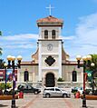
Iglesia de Nuestra Señora del Carmen
-
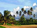
Playa Sardinera
-
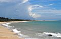
Playa La Marina in Hatillo
-
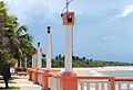
Paseo del Carmen
-

Plaza del Norte Mall


Gallery
-
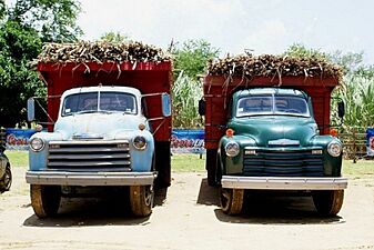
Festival de la Caña, Hatillo
-
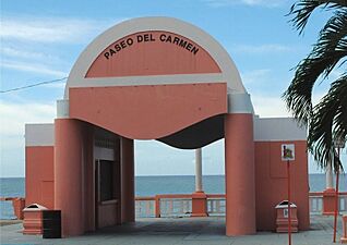
Paseo del Carmen
-
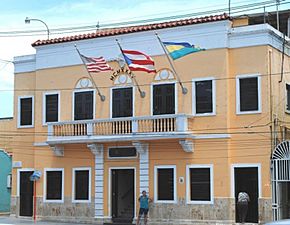
Town Hall of Hatillo
-
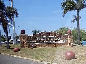
Welcome rock wall
-
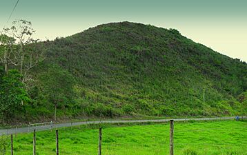
Mogote on a road in Hatillo
-
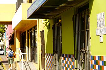
Calle Padre Delgado - barrio-pueblo
-
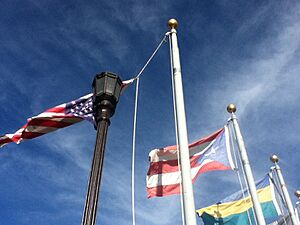
United States, Puerto Rico and Hatillo flags in Hatillo


See also
 In Spanish: Hatillo (Puerto Rico) para niños
