
Camuy, Puerto Rico facts for kids
Quick facts for kids
Camuy
Municipio Autónomo de Camuy
|
|||
|---|---|---|---|
|
Town and Municipality
|
|||
 |
|||
|
|||
| Nicknames:
"Ciudad Romántica", "Ciudad de los Areneros", "Ciudad del Sol Taíno, "Valle de las Cavernas"
|
|||
| Anthem: "Pedazo de Borinquen" | |||

Map of Puerto Rico highlighting Camuy Municipality
|
|||
| Sovereign state | |||
| Commonwealth | |||
| Settled | early 19th century | ||
| Founded | June 12, 1807 | ||
| Founded by | Don Ignacio Jiménez | ||
| Barrios | |||
| Area | |||
| • Total | 61.91 sq mi (160.3 km2) | ||
| • Land | 46.43 sq mi (120.3 km2) | ||
| • Water | 15.49 sq mi (40.1 km2) | ||
| Population
(2020)
|
|||
| • Total | 32,827 | ||
| • Rank | 37th in Puerto Rico | ||
| • Density | 530.24/sq mi (204.726/km2) | ||
| Demonym(s) | Camuyanos | ||
| Time zone | UTC−4 (AST) | ||
| ZIP Code |
00627
|
||
| Area code(s) | 787/939 | ||
| Major routes | |||


Camuy is a town and municipality in Puerto Rico. It is located on the northern coast, right by the Atlantic Ocean. Camuy is west of Hatillo and east of Quebradillas. It is also north of Lares and San Sebastián.
The town is divided into 12 areas called barrios, plus the main downtown area known as Camuy Pueblo. Camuy celebrated its 200th birthday in 2007. It is part of the "Porta Atlántico" Tourist Area, which means it's a great place for visitors!
Contents
Exploring Camuy's Past
Camuy is often called the "Romantic City" (la ciudad romántica). It was founded in 1807 by Petronila Matos. Before that, it was part of Arecibo. Camuy is in the northwest coastal area of Puerto Rico. You can find it easily on PR-2 and PR-119.
What Does "Camuy" Mean?
The name Camuy comes from the Taíno language. There are a few interesting stories about what it means. One story says it means "sun." Another says it means "beautiful scenery." A third story suggests it came from the name of a Taíno chief, Yumac, with the letters reversed. The "sun" story is even shown on Camuy's official coat of arms!
Camuy's Early Days
In 1846, a bridge called Puente Camuy was built over the Camuy River. This bridge connected Camuy with Hatillo. After the Spanish–American War, Spain gave Puerto Rico to the United States. In 1899, a count of the population showed that 10,887 people lived in Camuy.
Long ago, Camuy was part of a huge land area called the Partition of San Antonio de la Tuna. This big area included what are now the towns of Camuy, Hatillo, Quebradillas, Isabela, Utuado, and San Sebastián.
Camuy Today: Population and Challenges
In 2010, Camuy had a population of 35,159 people. It covers about 46.3 square miles of land. Camuy is part of the larger San Juan metropolitan area. It's a popular place to live, like a suburb of a big city. In 2015, the U.S. Conference of Mayors even named Camuy one of the most livable cities in the United States.
However, Camuy has faced tough times. In 2017, Hurricane Maria caused many landslides because of heavy rain. About 2,000 homes were damaged or destroyed. The hospital roof was torn off. Farms, animal businesses, and tourist spots were badly hit. The famous Parque Nacional de las Cavernas del Río Camuy was damaged and closed for four years.
Discovering Camuy's Landscape

Camuy is located on a flat area known as the Valley of Quebradillas. It's part of Puerto Rico's Northern Karst zone. This means it has unique landscapes with limestone rocks and caves. In the middle of Camuy, the land becomes very uneven, with wooded hills and dips. This area divides Camuy into two parts: north and south.
The Amazing Camuy River Caves
The Camuy River is a big part of Camuy's natural beauty. It is 24 miles long. At one point, the river goes underground into a narrow canyon. This forms one of the most incredible cave systems in the world: the Rio Camuy Caverns. Explorers first found these caves in 1958.
The Rio Camuy Caverns are the third largest and longest underground cave system in the world! The Camuy River is also one of the few active underground rivers left in the Americas. The Cibao River also flows into this amazing system.
Camuy's Barrios
Like all towns in Puerto Rico, Camuy is divided into smaller areas called barrios. The main town square, municipal buildings, and a large Catholic church are in a barrio called "el pueblo".
- Abra Honda
- Camuy barrio-pueblo
- Camuy Arriba
- Cibao
- Ciénagas
- Membrillo
- Piedra Gorda
- Puente
- Puertos
- Quebrada
- Santiago
- Yeguada
- Zanja
People of Camuy
| Historical population | |||
|---|---|---|---|
| Census | Pop. | %± | |
| 1900 | 10,887 | — | |
| 1910 | 11,342 | 4.2% | |
| 1920 | 14,228 | 25.4% | |
| 1930 | 16,149 | 13.5% | |
| 1940 | 18,922 | 17.2% | |
| 1950 | 20,886 | 10.4% | |
| 1960 | 19,739 | −5.5% | |
| 1970 | 19,922 | 0.9% | |
| 1980 | 24,884 | 24.9% | |
| 1990 | 28,917 | 16.2% | |
| 2000 | 35,244 | 21.9% | |
| 2010 | 35,159 | −0.2% | |
| 2020 | 32,827 | −6.6% | |
| U.S. Decennial Census 1899 (shown as 1900) 1910-1930 1930-1950 1960-2000 2010 2020 |
|||
The people of Camuy are called Camuyanos. The population has grown a lot over the years. In 2020, about 32,827 people lived in Camuy.
Fun Things to Do in Camuy
Camuy is famous for its Camuy River Cave Park. This park has a huge network of natural limestone caves and underground rivers. It's shared with the nearby towns of Hatillo and Lares. The park offers tours of some of the caves. It is one of the most popular natural attractions in Puerto Rico.

Beaches and Other Sights
Camuy has 9 beautiful beaches, including Peñón Brussi. Other cool places to visit in Camuy are:
- Hacienda Morell
- Peñon Brusi Beach
- Peñon Amador Beach (where you might see flamingos!)
- Rio Camuy Cave Park
- Paseo Tablado del Río Camuy (a boardwalk by the river)
- Ernesto Memorial Chapel
- Camuy History Museum
To encourage people to explore Puerto Rico, a "Voy Turisteando" (I'm Touring) campaign was started. The Camuy page in the "Voy Turisteando" passport suggests visiting Iglesia de Piedra, Balneario Peñon Brusi, and Parque de Las Cavernas del Río Camuy.
Camuy's Culture and Traditions
Religion in Camuy
.jpg)
Most people in Camuy are Catholic. But there are also other religions, like Protestant churches (Pentecostals, Presbyterians, Methodists).
There are four Roman Catholic churches in Camuy:
- The San Jose Parish, named after the town's patron saint, in the town square.
- The Miraculous Medal (also called "El Calvario") in Piedra Gorda.
- The Assumption of Mary in Quebrada.
- Our Lady of Montserrate in Soller, near Quebradillas.
The Ernesto Memorial Chapel, a Methodist church, is also known as Iglesia de Piedra (Church of Stone). It's famous because it was handmade using limestones and is on the US National Register of Historic Places.
Sports in Camuy
Camuy loves sports! The town has many local teams for volleyball, basketball, martial arts, and swimming. But their baseball teams are the most famous. There are little league and intermediate teams. At the top level, there are two professional Class A and Double AA baseball teams called "Los Arenosos." This name means "The Sandy Ones," referring to the sand from the coastline.
Festivals and Events
Camuy's patron saint is Saint Joseph. His day is celebrated on March 1. The main town festivals (Fiestas Patronales) happen every year around the last two weeks of March. Other fun festivals and celebrations in Camuy include:
- Velorio Tres Reyes Magos or Three Kings Celebration - January
- Mondongazo Festival - February
- Camuy Carnival - February
- Balseada del Río Camuy and 5k Race - March
- Patron Festivities San José - March
- "Reviving Our Traditions Festival" - June
- Peñon Brussi Beach Festival - July
- Municipal Cultural Fair - November
Camuy's Economy
Farming and Business

Camuy has a history of farming, especially sugarcane long ago. Today, cattle and milk production are important.
There's also a strong manufacturing industry in Camuy. Companies like Cazador Apparel, Seamless Textiles, Hanes, Best Quality Coop, and Camuy Furniture Warehouse are located here. SNC Technical Services is another textile company that started production in 2019.
You can find many fast-food restaurants, banks, and stores in Camuy. There are also plans to build new shopping centers. Tourism is a big part of Camuy's economy, thanks to the Rio Camuy Caves and its beautiful public beaches.
Education in Camuy
Camuy has 17 public schools and a community college, offering many learning opportunities for its young people.
Symbols of Camuy
Camuy has its own official flag and coat of arms.
The Flag
The flag is green, just like the coat of arms. A white wavy band goes across the flag. In the middle, it has a symbol of the Camuy sun, shown in yellow and black.
The Coat of Arms
The silver wavy stripe on the coat of arms stands for the Camuy River. It's broken in the middle because the river goes underground for part of its journey. The crown with three towers shows that Camuy is a municipality (a self-governing town).
Images for kids
-
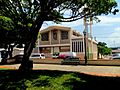
The Camuy parish church in downtown Camuy
-
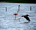
Flamingo and other birds in Yeguada barrio in Camuy
-
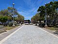
Luis Muñoz Marín town square


See also
 In Spanish: Camuy para niños
