
Manatí, Puerto Rico facts for kids
Quick facts for kids
Manatí
Municipio Autónomo de Manatí
|
|||
|---|---|---|---|
|
City and municipality
|
|||

Town Hall in Manatí
|
|||
|
|||
| Nicknames:
"Ciudad Metropolitana", "La Atenas de Puerto Rico"
|
|||
| Anthem: "Atenas de Borinquen" | |||

Map of Puerto Rico highlighting Manatí Municipality
|
|||
| Sovereign state | |||
| Commonwealth | |||
| Settled | 1680 | ||
| Founded | June 29, 1738 | ||
| Founded by | Pedro Menéndez de Valdés | ||
| Barrios | |||
| Area | |||
| • Total | 56.19 sq mi (145.53 km2) | ||
| • Land | 50 sq mi (120 km2) | ||
| • Water | 9.86 sq mi (25.53 km2) | ||
| Population
(2020)
|
|||
| • Total | 39,492 | ||
| • Rank | 23rd in Puerto Rico | ||
| • Density | 702.84/sq mi (271.367/km2) | ||
| Demonym(s) | Manatieños | ||
| Time zone | UTC−4 (AST) | ||
| ZIP Code |
00674
|
||
| Area code(s) | 787/939 | ||
| Major routes | |||


Manatí is a city and a municipality located on the northern coast of Puerto Rico. It is north of Morovis and Ciales. To its east are Florida and Barceloneta, and to its west is Vega Baja.
Manatí has more than 8 areas called barrios, plus the downtown area known as Manatí barrio-pueblo. This downtown area is the main administrative center of the city. Manatí is also part of the larger San Juan-Caguas-Guaynabo Metropolitan Statistical Area.
Contents
History of Manatí
Manatí was officially founded on June 29, 1738, by Don Pedro Menendez Valdes. The famous Iglesia Nuestra Señora de la Candelaria church was built in the 1600s and still stands in its original spot today.
The city is known by two special nicknames: "La Ciudad Metropolitana" (The Metropolitan City) and "La Atenas de Puerto Rico" (The Athens of Puerto Rico). The name Manatí comes from the manatee, a large sea mammal also known as a sea cow.
In the early days, the mayor of the town was Jose Aulet. Long ago, Juan Ponce de León chose the Manuatabón River in Manatí as one of the first places to search for gold. The Aulet family owned land that was very rich in pineapples, sugar cane, and green bananas. They later sold this land to the government in 1985.
Around 1853, the area changed from mining to farming, especially growing and processing sugar cane. Sugar was in high demand and sold for good prices around the world. Carpentry also became a popular trade. At that time, Manatí had 280 homes, 2 town squares, 8 streets, and a school with 50 students.
Geography of Manatí
Manatí is located on the northern central coast of Puerto Rico. It is part of a special area known as the Northern Karst region.
Manatí's Barrios
Like all municipalities in Puerto Rico, Manatí is divided into smaller areas called barrios. The main government buildings, the central town square, and a large Catholic church are all found in the center of the municipality. This central barrio is known as "el pueblo".
Sectors within Barrios
Barrios are further divided into even smaller areas called sectores (which means sectors in English). These sectors can have different names like urbanización, reparto, barriada, or residencial.
Special Communities
Some communities in Puerto Rico are called Comunidades Especiales de Puerto Rico (Special Communities of Puerto Rico). These are areas where people might need extra help and support. In 2014, some of these special communities in Manatí included Cerro Gandía, Cerro Quiñones, and El Horno.
Climate
| Climate data for Manati 2E, Puerto Rico (1991–2020 normals, extremes 1900–present) | |||||||||||||
|---|---|---|---|---|---|---|---|---|---|---|---|---|---|
| Month | Jan | Feb | Mar | Apr | May | Jun | Jul | Aug | Sep | Oct | Nov | Dec | Year |
| Record high °F (°C) | 92 (33) |
96 (36) |
97 (36) |
99 (37) |
99 (37) |
100 (38) |
100 (38) |
98 (37) |
98 (37) |
98 (37) |
98 (37) |
95 (35) |
100 (38) |
| Mean daily maximum °F (°C) | 81.2 (27.3) |
81.8 (27.7) |
82.7 (28.2) |
83.8 (28.8) |
85.2 (29.6) |
87.0 (30.6) |
86.4 (30.2) |
87.2 (30.7) |
87.2 (30.7) |
86.6 (30.3) |
84.1 (28.9) |
82.3 (27.9) |
84.6 (29.2) |
| Daily mean °F (°C) | 73.4 (23.0) |
73.5 (23.1) |
74.2 (23.4) |
75.7 (24.3) |
77.5 (25.3) |
79.4 (26.3) |
79.3 (26.3) |
79.8 (26.6) |
79.4 (26.3) |
78.7 (25.9) |
76.7 (24.8) |
74.8 (23.8) |
76.9 (24.9) |
| Mean daily minimum °F (°C) | 65.6 (18.7) |
65.2 (18.4) |
65.7 (18.7) |
67.7 (19.8) |
69.8 (21.0) |
71.7 (22.1) |
72.1 (22.3) |
72.4 (22.4) |
71.6 (22.0) |
70.7 (21.5) |
69.2 (20.7) |
67.4 (19.7) |
69.1 (20.6) |
| Record low °F (°C) | 50 (10) |
51 (11) |
53 (12) |
54 (12) |
55 (13) |
58 (14) |
58 (14) |
59 (15) |
60 (16) |
60 (16) |
59 (15) |
57 (14) |
50 (10) |
| Average precipitation inches (mm) | 5.09 (129) |
3.16 (80) |
4.07 (103) |
4.91 (125) |
6.21 (158) |
3.41 (87) |
5.35 (136) |
5.36 (136) |
5.67 (144) |
5.67 (144) |
7.59 (193) |
5.39 (137) |
61.88 (1,572) |
| Average precipitation days (≥ 0.01 in) | 14.6 | 11.7 | 10.2 | 11.5 | 13.9 | 10.8 | 14.0 | 14.6 | 13.9 | 14.6 | 17.2 | 16.2 | 163.2 |
| Source: NOAA | |||||||||||||
Population of Manatí
| Historical population | |||
|---|---|---|---|
| Census | Pop. | %± | |
| 1900 | 13,989 | — | |
| 1910 | 17,240 | 23.2% | |
| 1920 | 20,100 | 16.6% | |
| 1930 | 24,838 | 23.6% | |
| 1940 | 29,366 | 18.2% | |
| 1950 | 30,449 | 3.7% | |
| 1960 | 29,354 | −3.6% | |
| 1970 | 30,559 | 4.1% | |
| 1980 | 36,562 | 19.6% | |
| 1990 | 38,692 | 5.8% | |
| 2000 | 45,409 | 17.4% | |
| 2010 | 44,113 | −2.9% | |
| 2020 | 39,492 | −10.5% | |
| U.S. Decennial Census 1899 (shown as 1900) 1910–1930 1930–1950 1960–2000 2010 2020 |
|||
Visiting Manatí
In 2014, Manatí got its first hotel, the Hyatt Place Hotel and Casino. It is located next to Casino Atlántico and a LongHorn Steakhouse. The hotel has an outdoor swimming pool, meeting rooms, and a fitness center.
Manatí is famous for its beautiful beaches. It is part of the Porta Atlantico tourism district, which is a popular area for visitors. In 2019, Manatí started offering free tours of its city, beaches, historic spots, and local restaurants.
Landmarks and Fun Places to Visit
Here are some interesting places you can visit in Manatí:

- The Acropolis Sports Complex
- Biblioteca Nacional Francisco Álvarez (National Library)
- El Salón del Poeta (The Poet's Hall)
- Historic Zone (the old downtown area)
- Los Tubos Beach
- La Esperanza Beach and Hacienda Azucarera la Esperanza (a historic sugar plantation)
- Playa Cueva Las Golondrinas (Swallows Cave Beach)
- Mar Chiquita Beach, which is considered the most popular beach in the city.
- Marqués de la Esperanza Hacienda Ruins (old plantation ruins)
- Ruinas de la Oficina de la Central Monserrate (Ruins of the Monserrate Sugar Mill Office)
- The New Manati Arena
- Manati Baseball Stadium
- Playa Poza de las Mujeres, which is known for its strong currents.
Economy of Manatí
Agriculture
Isidoro Colón started the "Candelaria" sugar mill between 1860 and 1870, located between Manatí and Barceloneta. Manatí is known as the pineapple capital of Puerto Rico. Farmers also grow other fruits, sugar cane, and coffee. Los Frutos del Guacabo is a local farm that provides fresh fruits and vegetables to chefs in the area.
Industry
Manatí has industries that make shoes and wood products. There is also a pineapple cannery. Many pharmaceutical companies have factories here, including:
- Bristol-Myers Squibb
- Warner Chilcott
- DuPont
- Patheon
- Actavis
- Janssen Ortho LLC
Retailers
- Burlington store
Healthcare in Manatí
Manatí has two large private hospitals: Doctor's Center Hospital and Manati Medical Center Dr. Otero Lopez. There is also a smaller Municipal Hospital. The area around PR-2 has many medical offices.
Education in Manatí
Manatí has three public high schools: Petra Corretjer de O'neill High School, Fernando Callejo High School, and the Escuela Instituto Tecnologico Recinto De Manati, which is also a technical institute.
Private Schools:
- Colegio Marista «El Salvador», Manatí
- Colegio De La Inmaculada
- Piaget Bilingual Academy
- Academia Discípulos de Cristo
- Higher Education Academy
- La Reiné Christian Bilingual School
The only university in Manatí is the American University of Puerto Rico, Manatí Campus. There are also several technical schools like Instituto de Banca y Comercio, Atenas College, EDP College, and Dewey University.
Transportation in Manatí
There are 15 bridges located in Manatí.
Culture of Manatí
Festivals and Events
Manatí celebrates its patron saint festival in February. This festival, called Fiestas Patronales Virgen de la Candelaria, is a religious and cultural event. It usually includes parades, games, local crafts, amusement rides, traditional food, and live entertainment.
Other fun festivals and events in Manatí include:
- Los Tubos beach festival – held in June or July
- Mar Chiquita festival – held in June
- Christmas festival – held in December
Radio Stations
- WMNT (AM) - Radio Atenas 1500 AM
- WNRT FM - Triunfo 96.9 FM
Famous People from Manatí
Many notable people come from Manatí, including:
- Cecilia Callejo, a dancer and actress
- José Miguel Class, a singer
- Noel Cuevas, a professional baseball player
- Manuel Ramos Otero, a poet and activist
- Carlos Santana Becerra, a judge
- Yara Sofia, a drag queen
- Antonio Vélez Alvarado, known as the father of the Puerto Rican flag
- Carlos Beltrán, a professional baseball outfielder
- Neftalí Soto, a professional baseball player
- Iván Rodríguez, a professional baseball player
- José Valentin, a professional baseball player
- Luis Daniel Rivera, an actor and politician
Images for kids
-
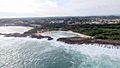
Mar Chiquita beach and bay in Manatí
-
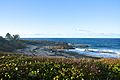
Cueva de las Golondrinas
-
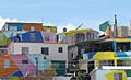
Buildings near the Manatí barrio-pueblo
-
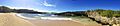
Beach in Manatí
.jpg)


See also
 In Spanish: Manatí (Puerto Rico) para niños
