
Vega Baja, Puerto Rico facts for kids
Quick facts for kids
Vega Baja
Municipio Autónomo de Vega Baja
|
|||
|---|---|---|---|
|
City and municipality
|
|||

Ciudad del Melao Melao welcome sign in Vega Baja
|
|||
|
|||
| Nickname(s):
"Ciudad del Melao Melao"
|
|||
| Anthem: "A Vega Baja" | |||

Map of Puerto Rico highlighting Vega Baja Municipality
|
|||
| Sovereign state | |||
| Commonwealth | |||
| Founded | October 7, 1776 | ||
| Barrios | |||
| Area | |||
| • Total | 55.71 sq mi (144.28 km2) | ||
| • Land | 47 sq mi (122 km2) | ||
| • Water | 8.60 sq mi (22.28 km2) | ||
| Population
(2020)
|
|||
| • Total | 54,414 | ||
| • Rank | 13th in Puerto Rico | ||
| • Density | 976.79/sq mi (377.142/km2) | ||
| Demonym(s) | Vegabajeños | ||
| Time zone | UTC-4 (AST) | ||
| ZIP Codes |
00693, 00694
|
||
| Area code(s) | 787/939 | ||
| Major routes | |||


Vega Baja is a town and municipality located on the north central coast of Puerto Rico. It is north of Morovis, east of Manatí, and west of Vega Alta. Vega Baja is divided into 14 areas called barrios. In 2020, about 54,414 people lived there. It is part of the larger San Juan metropolitan area.
Contents
History of Vega Baja
The name Vega Baja means 'lower valley' in Spanish. Historians believe the name comes from "La Vega," which was a family name important in the town's founding. It might also come from a region in Spain called "La Vega Baja del Segura." In the Caribbean Spanish language, a vega can also mean a tobacco farm.
Vega Baja was officially founded on October 7, 1776. This day is also when people remember the Virgin of the Rosary. The town was first known by a longer name: Vega-baxa del Naranjal de Nuestra Señora del Rosario. This means "Vega Baja of the Orange Grove of Our Lady of the Rosary."
The Cibuco River flows through Vega Baja. Its name comes from Sebuco, who was a chief of the Taíno people. These early tribes often lived near rivers. Even though the Cibuco River can flood when it rains a lot, it also makes the land very fertile.
Ancient Taíno rock carvings have been found near the Cibuco River. Some carvings show faces, and others look like fish. This suggests that the Taíno people used these areas for fishing and other daily activities. Other places like Carmelita, Maisabel, Cueva Maldita, and Paso del Indio are important archaeological sites where these early communities lived.
On September 20, 2017, Hurricane Maria hit Puerto Rico. Vega Baja, with its coastal and mountainous areas, was greatly affected. The hurricane caused many landslides and rivers overflowed, flooding low-lying areas. Homes and other buildings were destroyed.
The Cibuco River quickly rose, putting many lives at risk. People had to seek safety on roofs or use small boats to rescue others. Local staff helped by taking people to a shelter at the Lino Padrón school. However, the school's power generator and water tank did not work. Communication systems were damaged, making it hard for rescue teams to talk to each other. The mayor, whose own home was destroyed, described the widespread damage. Roads were blocked by fallen trees and power lines. The Cibuco River even rose over PR-2, making it impossible to travel to nearby towns.
Geography of Vega Baja
.jpg)
Vega Baja is located on the northern coast of Puerto Rico. The municipality is part of the Northern Karst region, which has unique limestone formations. The main town area is on the Northern Plains.
Barrios of Vega Baja

Like all municipalities in Puerto Rico, Vega Baja is divided into smaller areas called barrios. The main town buildings, central square, and large Catholic church are in a barrio called "Pueblo".
- Algarrobo
- Almirante Norte
- Almirante Sur
- Cabo Caribe
- Ceiba
- Cibuco
- Puerto Nuevo
- Pugnado Adentro
- Pugnado Afuera
- Quebrada Arenas
- Río Abajo
- Río Arriba
- Pueblo
- Yeguada
Sectors in Vega Baja
Barrios are further divided into even smaller areas called sectores (sectors). These sectors can have different names like urbanización (urbanization) or barriada (neighborhood).
Special Communities in Vega Baja
Comunidades Especiales de Puerto Rico (Special Communities of Puerto Rico) are areas that need extra support. These communities are found in almost every municipality. In Vega Baja, some of these special communities include Alto de Cuba, Callejón Pérez, Sector El Hoyo in Barrio Algarrobo, Guarico Viejo, and La Trocha-Río Abajo.
Population of Vega Baja
| Historical population | |||
|---|---|---|---|
| Census | Pop. | %± | |
| 1900 | 10,305 | — | |
| 1910 | 12,831 | 24.5% | |
| 1920 | 15,756 | 22.8% | |
| 1930 | 20,406 | 29.5% | |
| 1940 | 23,105 | 13.2% | |
| 1950 | 28,925 | 25.2% | |
| 1960 | 30,189 | 4.4% | |
| 1970 | 35,327 | 17.0% | |
| 1980 | 47,115 | 33.4% | |
| 1990 | 55,997 | 18.9% | |
| 2000 | 61,929 | 10.6% | |
| 2010 | 59,662 | −3.7% | |
| 2020 | 54,414 | −8.8% | |
| U.S. Decennial Census 1899 (shown as 1900) 1910-1930 1930-1950 1960-2000 2010 2020 |
|||
After the Spanish–American War, Puerto Rico became a territory of the United States. In 1899, the first census of Puerto Rico counted 10,305 people living in Vega Baja.
| Vega Baja - 2020 census | ||
|---|---|---|
| Race | Population | % |
| White alone | 10,042 | 18.5 |
| Black or Afro-Puerto Rican | 3,491 | 6.4 |
| American Indian/Alaska Native | 460 | 0.8 |
| Asian alone | 28 | 0.1 |
| Native Hawaiian and other Pacific Islander alone | 9 | 0.0 |
| Some other race alone | 13,783 | 25.3 |
| Two or More Races alone | 26,601 | 48.9 |
Tourism in Vega Baja
Vega Baja has 14 beaches for visitors to enjoy.
Landmarks and Places of Interest
Some popular places to visit in Vega Baja include:
- Casa Alcaldía (the historic city hall)
- Casa Alonso Museum
- Casa Portela Museum
- Cibuco Swamp
- El Trece Recreational Area
- Vega Baja House of Culture and Tourism
- Man of the Sugar Cane Monument
- Melao Melao Artisan Center
- Migrants Square
- Museo del Salon de la Fama del Deporte Vega Baja Melao Melao (Sports Hall of Fame Museum)
- Puerto Nuevo Beach and its recreational area
- José Francisco Náter Square (the main town square)
- Teatro América
- Teatro Fénix
- Tortuguero Lagoon
- Tortuguero Recreational Area
- Trinitarias Park
Economy of Vega Baja

Vega Baja has very fertile soil, which means it has a lot of land for farming. It also has one of the most visited beaches on the northern coast, Puerto Nuevo Beach (also called Mar Bella Beach). This beach brings in many visitors, especially in the summer. It has a huge natural rock formation called La Peña. This rock protects the beach from the strong ocean waves. When the sea is rough, you can safely watch the waves crash over the rock.
Agriculture
- Farmers grow pineapple and hay for cattle. In the past, sugar cane was also grown in areas like Monte Carlo and Los Naranjos.
- Dairy farming is also important.
Industry
- Factories in Vega Baja make clothing and leather items.
- They also produce electrical and electronic equipment, and machinery.
- Medical and pharmaceutical products are made here too.
Culture in Vega Baja
Festivals and Events
Vega Baja celebrates its patron saint festival in October. This festival, called Fiestas Patronales de Nuestra Virgen del Rosario, is a religious and cultural event. It usually includes parades, games, local crafts, rides, traditional food, and live music.
Other fun festivals and events in Vega Baja are:
- Three Kings Festival – January
- Triathlon – March
- Annual Tournament of Champions – June
- San Juan Night – June
- Virgen del Carmen Festival – July
- Beach Festival at Mar Bella - July
- Socio-Cultural Fair – May
- Melao Melao Festival – October
- Christmas Festival – December
Transportation in Vega Baja
Vega Baja has 23 bridges that help people travel around the municipality.
Notable People from Vega Baja
- Bad Bunny – A famous rapper, singer, and actor.
- Chicky Starr – A professional wrestler and manager.
- Ivan Rodriguez – Known as “Pudge,” he is a Hall of Fame baseball player. He was a catcher, mostly for the Texas Rangers.
- Juan Gonzalez – A great baseball player who won the AL MVP award twice. He also played mostly for the Texas Rangers.
Symbols of Vega Baja
The municipality has its own official flag and coat of arms.
Flag
Vega Baja's flag is yellow with a green band crossing it. The green band represents the fertile valley and the river.
Coat of arms
The coat of arms has a green V-shaped band with silver roses and three orange trees with gold fruit. At the top, there is a silver, black, and green crown with five towers. The main colors, green and gold, are often used in local events. The five-tower crown shows that the town has the special rank of "Villa" by royal decree.
Anthem
The anthem of Vega Baja is called "A Vega Baja." The words were written in 1974 by Adrián Santos Tirado, and the music was composed by Roberto Sierra.
Education in Vega Baja

Here are some of the schools in Vega Baja:
- Agapito Rosario Rosario (Grades: K - 5)
- Angel Sandin Martinez (Grades: 6 - 8)
- Centro De Adiestramiento
- Juan Quirindongo Morell (Superior) (Grades: 9 - 12)
- Lino Padro Rivera (Grades: 9 - 12)
- Manuel Martinez Davila (Grades: K - 8)
- Nueva Brigida Alvarez Rodriguez (Grades: K - 12)
- Rafael Hernandez (Grades: K - 5)
- San Vicente (Grades: K - 5)
- Su Almirante Norte (Grades: Pre-K - 8)
Higher Education
- Caribbean University-Vega Baja: This is a private, non-profit university offering 4-year degrees or more.
Private School
- Mech-Tech College
Images for kids
-
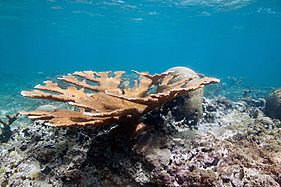
Elkhorn coral near the coast of Vega Baja.
-
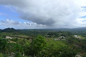
View of Vega Baja in Pugnado Adentro.
-
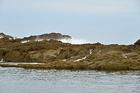
Limestone rock in Mar Bella Beach (Puerto Nuevo Beach).
-
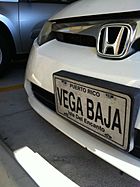
Vega Baja license plate in Altamonte Springs, Florida.

.jpg)

.jpg)

See also
 In Spanish: Vega Baja (Puerto Rico) para niños
