
Quebrada Arenas, Vega Baja, Puerto Rico facts for kids
Quick facts for kids
Quebrada Arenas
|
|
|---|---|
|
Barrio
|
|
.jpg)
Indio River between Quebrada Arenas and Almirante Sur
|
|

Location of Quebrada Arenas within the municipality of Vega Baja shown in red
|
|

Quebrada Arenas, Vega Baja, Puerto Rico
Location in Caribbean
|
|
| Commonwealth | |
| Municipality | |
| Area | |
| • Total | 1.81 sq mi (4.7 km2) |
| • Land | 1.81 sq mi (4.7 km2) |
| • Water | 0 sq mi (0 km2) |
| Elevation | 482 ft (147 m) |
| Population
(2010)
|
|
| • Total | 773 |
| • Density | 424.7/sq mi (164.0/km2) |
| Source: 2010 Census | |
| Time zone | UTC−4 (AST) |
Quebrada Arenas is a small community, also known as a barrio, located in the municipality of Vega Baja, Puerto Rico. In 2010, about 773 people lived there. It's a part of the beautiful island of Puerto Rico.
History of Quebrada Arenas
Puerto Rico became a territory of the United States after the Spanish–American War in 1898. This happened because of an agreement called the Treaty of Paris of 1898.
After this change, the United States government started to count the people living in Puerto Rico. In 1899, the first count showed that 348 people lived in the Quebrada Arenas barrio. Over the years, the population has grown.
| Historical population | |||
|---|---|---|---|
| Census | Pop. | %± | |
| 1900 | 348 | — | |
| 1960 | 583 | — | |
| 1980 | 631 | — | |
| 1990 | 603 | −4.4% | |
| 2000 | 670 | 11.1% | |
| 2010 | 773 | 15.4% | |
| U.S. Decennial Census 1899 (shown as 1900) 1910-1930 1930-1950 1960 1980-2000 2010 |
|||
See also
In Spanish: Quebrada Arenas (Vega Baja) para niños
- List of communities in Puerto Rico
Images for kids
-
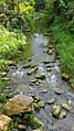
The Indio River flows between Quebrada Arenas and Almirante Sur.
-
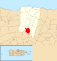
This map shows where Quebrada Arenas is located within Vega Baja.
