Coto Norte facts for kids
Quick facts for kids
Coto Norte
|
|
|---|---|
|
Barrio
|
|

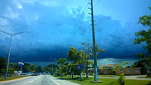
Puerto Rico Highway 149 in Coto Norte
|
|

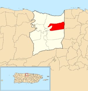
Location of Coto Norte within the municipality of Manatí shown in red
|
|
| Commonwealth | |
| Municipality | |
| Area | |
| • Total | 3.88 sq mi (10.0 km2) |
| • Land | 3.88 sq mi (10.0 km2) |
| • Water | 0 sq mi (0 km2) |
| Elevation | 161 ft (49 m) |
| Population
(2010)
|
|
| • Total | 11,250 |
| • Density | 2,899.5/sq mi (1,119.5/km2) |
| Source: 2010 Census | |
| Time zone | UTC−4 (AST) |
| ZIP code |
00674
|
Coto Norte is a special kind of neighborhood, called a barrio, located in the town of Manatí, Puerto Rico. It's mostly a rural area, meaning it has more open spaces and fewer big buildings. However, it also has a part that feels more like a city. In 2010, about 11,250 people lived in Coto Norte.
Contents
A Look at Coto Norte's Past
How Puerto Rico Became Part of the U.S.
Long ago, Spain used to control Puerto Rico. But after a big conflict called the Spanish–American War, Spain gave Puerto Rico to the United States. This happened because of an agreement called the Treaty of Paris of 1898.
After this, Puerto Rico became a special kind of place connected to the U.S. It's known as an "unincorporated territory." This means it's part of the U.S. but doesn't have all the same rights as a U.S. state.
Early Population Count
In 1899, the United States Department of War decided to count all the people living in Puerto Rico. This count is called a census. During this census, they found that Coto Norte and a nearby barrio called Coto Sur had a combined population of 2,110 people. This gives us an idea of how many people lived there over a hundred years ago!
See Also
- List of communities in Puerto Rico
 In Spanish: Coto Norte para niños
 | Selma Burke |
 | Pauline Powell Burns |
 | Frederick J. Brown |
 | Robert Blackburn |


