Río Arriba Poniente facts for kids
Quick facts for kids
Río Arriba Poniente
|
|
|---|---|
|
Barrio
|
|

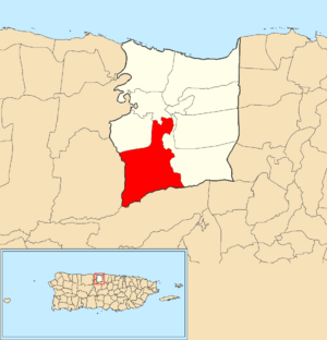
Location of Río Arriba Poniente within the municipality of Manatí shown in red
|
|
| Commonwealth | |
| Municipality | |
| Area | |
| • Total | 8.35 sq mi (21.6 km2) |
| • Land | 8.31 sq mi (21.5 km2) |
| • Water | 0.04 sq mi (0.1 km2) |
| Elevation | 617 ft (188 m) |
| Population
(2010)
|
|
| • Total | 1,857 |
| • Density | 223.5/sq mi (86.3/km2) |
| Source: 2010 Census | |
| Time zone | UTC−4 (AST) |
Río Arriba Poniente is a rural area, also known as a barrio, located in the municipality of Manatí, Puerto Rico. In 2010, about 1,857 people lived there. It covers an area of about 8.35 square miles.
History of Río Arriba Poniente
Puerto Rico became a territory of the United States after the Spanish–American War. This happened under the rules of the Treaty of Paris of 1898.
Early Census Data
In 1899, the United States government conducted a survey, or census, of Puerto Rico. This survey found that 1,862 people lived in the Río Arriba Poniente barrio at that time.
Population Changes Over Time
The number of people living in Río Arriba Poniente has changed quite a bit over the years.
- In 1900, there were 1,862 residents.
- The population grew to 2,650 by 1910.
- It continued to increase, reaching 3,208 in 1930 and 4,207 in 1940.
- After 1940, the population decreased for a while.
- By 1980, it was 1,599 people.
- The population slowly grew again, reaching 1,857 residents in 2010.
See also
- List of communities in Puerto Rico
- In Spanish: Río Arriba Poniente para niños
Black History Month on Kiddle
Contemporary African-American Artists:
 | Janet Taylor Pickett |
 | Synthia Saint James |
 | Howardena Pindell |
 | Faith Ringgold |

All content from Kiddle encyclopedia articles (including the article images and facts) can be freely used under Attribution-ShareAlike license, unless stated otherwise. Cite this article:
Río Arriba Poniente Facts for Kids. Kiddle Encyclopedia.

