
Guayanilla, Puerto Rico facts for kids
Quick facts for kids
Guayanilla
Municipio Autónomo de Guayanilla
|
|||
|---|---|---|---|
|
Town and Municipality
|
|||

Guayanilla Bay
|
|||
|
|||
| Nicknames:
"Tierra de Agüeybaná", "Los Corre en Yegua", "Capital Taina"
|
|||
| Anthem: "Guayanillenses, cantemos unidos" | |||

Map of Puerto Rico highlighting Guayanilla Municipality
|
|||
| Sovereign state | |||
| Commonwealth | |||
| Settled | 16th century | ||
| Founded | February 27, 1833 | ||
| Founded by | José de la Cueva y los Santos | ||
| Barrios | |||
| Area | |||
| • Total | 42.4 sq mi (109.9 km2) | ||
| Elevation | 161 ft (49 m) | ||
| Population
(2020)
|
|||
| • Total | 17,784 | ||
| • Rank | 63rd in Puerto Rico | ||
| • Density | 419.11/sq mi (161.82/km2) | ||
| Demonym(s) | Guayanillenses | ||
| Time zone | UTC−4 (AST) | ||
| ZIP Code |
00656
|
||
| Area code(s) | 787/939 | ||
| Major routes | |||
| GNIS feature ID | 1610861 | ||


Guayanilla is a town and municipality in Puerto Rico. It is located on the southern coast of the island, right next to the Caribbean Sea. Guayanilla is south of Adjuntas, east of Yauco, and west of Peñuelas. It is about 12 miles west of Ponce.
The municipality of Guayanilla includes 16 smaller areas called barrios. It also has a downtown area known as Guayanilla Pueblo. This town is part of the Yauco Metropolitan Statistical Area.
Contents
History of Guayanilla
Guayanilla was founded by people born in Puerto Rico who had Spanish ancestors, known as criollos. The town's first name was Guadianilla. This name came from a river and town in Spain. Later, the name was changed to Guayanilla. This was done to make it sound more like a native Taíno word. The name Guayanilla combines parts of "Guaynia" and "Santa Maria de Guadianilla".
Early Settlements and Founding
The first Europeans came to this area in 1511. In 1756, the nearby town of Yauco was founded. At that time, Guayanilla was a part of Yauco. The land here was very good for farming. Also, the local port was important for trade. Because of this, Guayanilla became a major farming area. Sugarcane was a very important crop grown here. Guayanilla grew quickly. It became its own separate municipality on February 27, 1833. This was made official by Governor Miguel de la Torre.
Becoming a U.S. Territory
After the Spanish–American War, Spain gave Puerto Rico to the United States. This happened under the Treaty of Paris of 1898. Puerto Rico then became a territory of the United States. In 1899, the U.S. government took a census of Puerto Rico. It showed that 9,540 people lived in Guayanilla.
Natural Disasters
On September 20, 2017, Hurricane Maria hit Puerto Rico. In Guayanilla, the hurricane caused many landslides. It also caused a lot of damage. About 600 homes lost their roofs. Around 300 homes were completely destroyed. Strong winds and floods ruined roads, crops, and buildings.
2019–2020 Earthquakes

Puerto Rico experienced several earthquakes in late 2019 and early 2020. On January 6, 2020, a 5.8 magnitude earthquake shook Guayanilla. Several buildings and cars were damaged. A family of eight had to escape their home, which was destroyed by the quake.
The next day, on January 7, 2020, a stronger 6.4 magnitude earthquake hit. This earthquake destroyed the Catholic church in Guayanilla Pueblo. A famous rock formation called "Playa Ventana" (Window Beach) was also destroyed.
Geography of Guayanilla
Guayanilla is located on the southern coast of Puerto Rico. The coastline forms the Guayanilla Bay. This bay is one of the best natural harbors in Puerto Rico. The closest big city is Ponce, which is about 12 miles to the east.
Mountains and Rivers
The northern parts of Guayanilla have mountains. These mountains are part of the Cordillera Central. They can reach up to 3,300 feet high. In the middle parts of the municipality, the land goes down. Here, the highest points are about 1,410 feet. Closer to the coast, the land is flatter. Elevations there are usually less than 951 feet.
Three rivers flow through Guayanilla: the Yauco River, the Guayanilla River, and the Macaná River. The Yauco River briefly flows through the Boca barrio. It then empties into the Caribbean Sea through marshy areas.
Barrios of Guayanilla

Like all municipalities in Puerto Rico, Guayanilla is divided into smaller areas called barrios. The main town area, with the municipal buildings, central square, and a large Catholic church, is called "el pueblo".
Here are the barrios in Guayanilla:
Sectors and Special Communities
Barrios are often divided into even smaller areas called sectores (sectors). These can have different names like urbanización or barriada.
Some communities in Puerto Rico are called Comunidades Especiales de Puerto Rico (Special Communities). These are areas where people might face challenges like social exclusion. In 2014, some of these special communities in Guayanilla included Magas Abajo, Villa del Carmen (in Playa barrio), Piedras Blancas, Playita, and San Pedro.
Tourism in Guayanilla
To encourage people to visit, the Puerto Rico Tourism Company created a campaign called Voy Turistiendo (meaning "I'm Touring"). It includes a passport book and a website. The Guayanilla page suggests visiting places like Paseo Tablado Guayacán (a boardwalk), Charco Los Peces (a fish pond), and Península del Río (a river peninsula).


Guayanilla has 17 beaches. Some popular places to visit include:
- Mario Mercado Castle
- Chorro de Oro Waterfall
- El Convento Cave
- Guilarte State Forest
- Emajagua Beach
- La Ventana Beach
- Tamarindo Beach
- Central Rufina Ruins
- El Castillo del Niño (The Child's Castle) amusement park.
Festivals and Events
Guayanilla celebrates many festivals throughout the year. These events often include parades, games, local crafts, food, and live music.
- Town Carnival (April)
- Student Festival (May)
- Beach Festival (May)
- Cross Festivities (May)
- Fishing Festival (June)
- Seafood Festival (June)
- Our Lady of Mount Carmel Festival (July)
- Ladies' Marathon (November)
- Immaculate Conception Festivities (December) - This is the main patron saint festival.
Economy of Guayanilla
The main industries in Guayanilla are making petrochemicals and producing electricity. Guayanilla creates more than half of Puerto Rico's electricity using thermoelectrical plants.
Here's a look at the types of jobs people have in Guayanilla:
- 22.2%: Education, healthcare, and social services
- 14.5%: Public administration (government jobs)
- 14.5%: Construction
- 11.3%: Manufacturing (making goods)
- 9.6%: Retail trade (stores)
- 6.4%: Transportation, warehousing, and utilities
- 5.3%: Arts, entertainment, recreation, hotels, and food services
- 4.5%: Other services
- 3.6%: Professional, scientific, management, and administrative services
- 2.9%: Agriculture, forestry, fishing, hunting, and mining
- 2.3%: Finance, insurance, real estate, and rental services
- 1.8%: Wholesale trade (selling goods to businesses)
- 1.2%: Information
Population and Demographics
| Historical population | |||
|---|---|---|---|
| Census | Pop. | %± | |
| 1900 | 9,540 | — | |
| 1910 | 10,354 | 8.5% | |
| 1920 | 12,083 | 16.7% | |
| 1930 | 13,121 | 8.6% | |
| 1940 | 15,577 | 18.7% | |
| 1950 | 17,402 | 11.7% | |
| 1960 | 17,396 | 0.0% | |
| 1970 | 18,144 | 4.3% | |
| 1980 | 21,050 | 16.0% | |
| 1990 | 21,581 | 2.5% | |
| 2000 | 23,072 | 6.9% | |
| 2010 | 21,581 | −6.5% | |
| 2020 | 17,784 | −17.6% | |
| U.S. Decennial Census 1899 (shown as 1900) 1910-1930 1930-1950 1960-2000 2010 2020 |
|||
In 2000, almost all of Guayanilla's population (99.2%) identified as Hispanic. Most people (65.5%) were white, 11.1% were black, and 19.3% were of mixed race.
About 40.9% of households had children under 18 living with them. The average household had about 3.19 people. The average family had about 3.55 people.
About 30.0% of the population was under 18 years old. The median age was 31 years. This means half the people were younger than 31 and half were older.
Symbols of Guayanilla
The municipality of Guayanilla has its own official flag and coat of arms.
Flag
Guayanilla has a unique flag that represents the municipality.
Coat of Arms
Guayanilla also has a coat of arms, which is a special design or shield that symbolizes its history and identity.
Education in Guayanilla
Guayanilla has several schools. Students from two of these schools, Escuela Arístides Cales Quirós and Asunción Rodríguez de Sala, have even performed in the famous Rose Parade in California multiple times.
Transportation
Guayanilla has 35 bridges, which help people travel across rivers and other natural features.
Nazario Collection
The Nazario Collection is a group of special inscribed stones. They were found by a Catholic priest and amateur archeologist named José M. Nazario. Many people believe these stones are linked to the Taíno chief Agüeybaná II. These statuettes are now the main attraction at Guayanilla's Father Nazario Museum of Lithic Epigraphy. They are an important cultural symbol for the town.
Images for kids
-
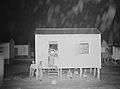
"Guayanilla, Puerto Rico. One of the houses in the company village for sugar cane workers" (1941 photograph by Jack Delano)
-
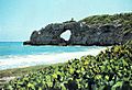
The Punta Ventana window feature collapsed during the 2019 earthquakes.
-
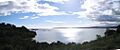
The Caribbean Sea from Guayanilla
-
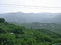
View of mountains in the countryside of Guayanilla
-
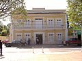
Guayanilla City Hall
-
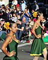
Guayanilla school band performing at a parade in California, US in 2012
-
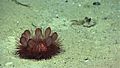
Photo by NOAA, Exploring Puerto Rico's Seamounts, Trenches, and Troughs (Guayanilla)


.jpg)

See also
 In Spanish: Guayanilla para niños
