Barrero, Guayanilla, Puerto Rico facts for kids
Quick facts for kids
Barrero
|
|
|---|---|
|
Barrio
|
|

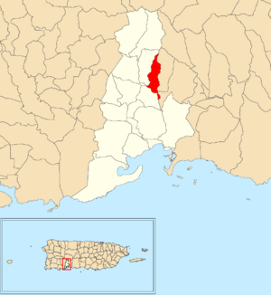
Location of Barrero within the municipality of Guayanilla shown in red
|
|
| Commonwealth | |
| Municipality | |
| Area | |
| • Total | 1.28 sq mi (3.3 km2) |
| • Land | 1.28 sq mi (3.3 km2) |
| • Water | 0 sq mi (0 km2) |
| Elevation | 656 ft (200 m) |
| Population
(2010)
|
|
| • Total | 839 |
| • Density | 655.5/sq mi (253.1/km2) |
| Source: 2010 Census | |
| Time zone | UTC−4 (AST) |
Barrero (which means Barrio Barrero in Spanish) is a small, quiet community. It is located in the countryside of Guayanilla, Puerto Rico. This type of neighborhood is called a barrio. In 2010, about 839 people lived there.
Exploring Barrero
Barrero covers about 1.28 square miles of land. That's roughly the size of 800 football fields! It has no large bodies of water. In 2010, 839 people lived here. This means there were about 655 people per square mile.
How Barrero's Population Changed
The number of people living in Barrero has changed over many years. Here's a look at its population from different times:
| Historical population | |||
|---|---|---|---|
| Census | Pop. | %± | |
| 1910 | 481 | — | |
| 1920 | 646 | 34.3% | |
| 1930 | 599 | −7.3% | |
| 1940 | 624 | 4.2% | |
| 1950 | 900 | 44.2% | |
| 1980 | 841 | — | |
| 1990 | 968 | 15.1% | |
| 2000 | 1,033 | 6.7% | |
| U.S. Decennial Census 1899 (shown as 1900) 1910-1930 1930-1950 1980-2000 2010 |
|||
A Glimpse into Barrero's Past
Puerto Rico was once controlled by Spain. After the Spanish–American War, Spain gave Puerto Rico to the United States. This happened under the rules of the Treaty of Paris of 1898. Puerto Rico then became a territory of the United States.
In 1899, the United States government counted everyone in Puerto Rico. This was part of a special survey. They found that the combined population of Barrero and a nearby area called Macaná was 1,154 people.
See also
 In Spanish: Barrero (Guayanilla) para niños
- List of communities in Puerto Rico
 | Kyle Baker |
 | Joseph Yoakum |
 | Laura Wheeler Waring |
 | Henry Ossawa Tanner |


