Macaná, Guayanilla, Puerto Rico facts for kids
Quick facts for kids
Macaná
|
|
|---|---|
|
Barrio
|
|

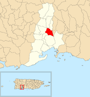
Location of Macaná within the municipality of Guayanilla shown in red
|
|
| Commonwealth | |
| Municipality | |
| Area | |
| • Total | 1.43 sq mi (3.7 km2) |
| • Land | 1.43 sq mi (3.7 km2) |
| • Water | 0 sq mi (0 km2) |
| Elevation | 427 ft (130 m) |
| Population
(2010)
|
|
| • Total | 1,483 |
| • Density | 1,037.1/sq mi (400.4/km2) |
| Source: 2010 Census | |
| Time zone | UTC−4 (AST) |
Macaná is a small community, also called a barrio, located in the town of Guayanilla, Puerto Rico. In 2010, about 1,483 people lived there.
Macaná: Quick Facts
Macaná covers about 1.43 square miles of land. It doesn't have any large bodies of water. In 2010, 1,483 people called Macaná home. This means there were about 1,037 people living in each square mile.
Every ten years, the United States counts all its people. This is called a census. It helps us understand how many people live in different places. Here's how Macaná's population has changed over the years:
| Historical population | |||
|---|---|---|---|
| Census | Pop. | %± | |
| 1910 | 664 | — | |
| 1920 | 750 | 13.0% | |
| 1930 | 849 | 13.2% | |
| 1940 | 954 | 12.4% | |
| 1950 | 752 | −21.2% | |
| 1980 | 1,333 | — | |
| 1990 | 1,195 | −10.4% | |
| 2000 | 1,446 | 21.0% | |
| 2010 | 1,483 | 2.6% | |
| U.S. Decennial Census 1899 (shown as 1900) 1910-1930 1930-1950 1980-2000 2010 |
|||
A Bit of History
Puerto Rico used to be controlled by Spain. After the Spanish–American War, Spain gave Puerto Rico to the United States. This happened because of an agreement called the Treaty of Paris of 1898. Puerto Rico then became a special area of the United States.
In 1899, the United States government counted everyone in Puerto Rico. This first count found that Macaná and a nearby area called Barrero had a combined population of 1,154 people.
See Also
 In Spanish: Macaná (Guayanilla) para niños
- List of communities in Puerto Rico
 | Shirley Ann Jackson |
 | Garett Morgan |
 | J. Ernest Wilkins Jr. |
 | Elijah McCoy |


