
Guayanilla barrio-pueblo facts for kids
Quick facts for kids
Guayanilla barrio-pueblo
Pueblo de Guayanilla
|
|
|---|---|
|
Municipality Seat
|
|

Statue of Luis Muñoz Marín, the 1st elected governor of Puerto Rico
|
|

Location of Guayanilla barrio-pueblo within the municipality of Guayanilla shown in red
|
|
| Lua error in Module:Location_map at line 416: Malformed coordinates value. | |
| Commonwealth | |
| Municipality | |
| Area | |
| • Total | 0.54 sq mi (1.4 km2) |
| • Land | 0.54 sq mi (1.4 km2) |
| • Water | 0 sq mi (0 km2) |
| Elevation | 52 ft (16 m) |
| Population
(2010)
|
|
| • Total | 3,757 |
| • Density | 6,957.4/sq mi (2,686.3/km2) |
| Source: 2010 Census | |
| Time zone | UTC−4 (AST) |
Guayanilla barrio-pueblo is a special part of Guayanilla, a town in Puerto Rico. It's like the main downtown area or city center. This is where the local government buildings are, making it the "seat" or administrative heart of the municipality. In 2010, about 3,757 people lived here.
In Puerto Rico, just like in Spain, each town has a central area called a pueblo. This area usually has a main plaza (a public square), the town hall, and a Catholic church. Every year, special festivals called Fiestas patronales (patron saint festivals) are held in this central plaza.
Contents
What is Guayanilla Barrio-Pueblo Like?
Guayanilla barrio-pueblo covers about 0.54 square miles of land. It doesn't have any large bodies of water within its area. In 2010, there were 3,757 people living there. This means it was quite a busy place, with many people living close together.
Here's how the population has changed over the years:
| Historical population | |||
|---|---|---|---|
| Census | Pop. | %± | |
| 1900 | 973 | — | |
| 1910 | 1,141 | 17.3% | |
| 1920 | 1,434 | 25.7% | |
| 1930 | 2,044 | 42.5% | |
| 1940 | 1,266 | −38.1% | |
| 1950 | 3,113 | 145.9% | |
| 1980 | 5,611 | — | |
| 1990 | 5,238 | −6.6% | |
| 2000 | 4,832 | −7.8% | |
| 2010 | 3,757 | −22.2% | |
| U.S. Decennial Census 1899 (shown as 1900) 1910-1930 1930-1950 1980-2000 2010 |
|||
The Central Plaza and Its Church
The central plaza, or town square, is a very important place. It's used for both official events and fun activities. People gather there to socialize from morning until night. Back in the early 1800s, Spanish laws called the Laws of the Indies said that plazas should be big enough for celebrations. They also said that nearby streets should have comfortable walkways to protect people from the sun and rain.
Right across from the central plaza in Guayanilla barrio-pueblo was the Parroquia Inmaculada Concepción. This was a Roman Catholic church. Sadly, this church was destroyed during the 2019–20 Puerto Rico earthquakes that hit the island.
A Look at History
After the Spanish–American War, Spain gave Puerto Rico to the United States. This happened under the Treaty of Paris of 1898. Puerto Rico then became an "unincorporated territory" of the U.S. In 1899, the U.S. government took a census (counted the population) of Puerto Rico. They found that 973 people lived in the Pueblo barrio at that time.
Earthquakes in 2020
On January 7, 2020, a strong earthquake with a magnitude of 6.4 hit the area. This earthquake destroyed the main church and other buildings in Guayanilla Pueblo. Just one day before, a smaller earthquake (magnitude 5.7) had already damaged several buildings and cars.
Gallery
-
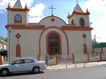
The Guayanilla Catholic Church is seen standing before its destruction by an earthquake in 2020
-
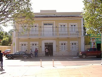
Guayanilla City Hall


See also
- List of communities in Puerto Rico
 In Spanish: Guayanilla (Guayanilla) para niños
