
Guayama, Puerto Rico facts for kids
Quick facts for kids
Guayama, Puerto Rico
Municipio Autónomo de Guayama
|
|||
|---|---|---|---|
| Autonomous Municipality of Guayama | |||
|
From top, left to right: Iglesia de San Antonio de Padua; Casa Cautiño; Colón Town Square; PR-54; Teatro Guayama; Hacienda Vives
|
|||
|
|||
| Nicknames:
"La ciudad del Guamaní"
Spanish for "The City of the Guamaní" "El pueblo de los brujos" Spanish for "The Witch City" |
|||

Map of Puerto Rico highlighting Guayama Municipality
|
|||
| Sovereign state | |||
| Commonwealth | |||
| Founded | January 29, 1736 | ||
| Founded by | Matías de Abadía | ||
| Barrios |
10 barrios
|
||
| Area | |||
| • Municipality | 106.8 sq mi (277 km2) | ||
| • Land | 65.0 sq mi (168 km2) | ||
| • Water | 41.8 sq mi (108 km2) | ||
| Elevation | 239 ft (73 m) | ||
| Population
(2020)
|
|||
| • Municipality | 36,614 | ||
| • Rank | 30th in Puerto Rico | ||
| • Density | 342.83/sq mi (132.37/km2) | ||
| • Metro | 68,442 (MSA) | ||
| Demonym(s) | Guayameses | ||
| Time zone | UTC−4 (Atlantic (AST)) | ||
| ZIP Codes |
00784, 00785
|
||
| Area code(s) | 787/939 | ||
| Major routes | |||
| GNIS feature ID | 1610860 | ||


.jpg)


Guayama is a city and municipality located on the Caribbean coast of Puerto Rico. It is also known as the Autonomous Municipality of Guayama. In 2020, the city had a population of 36,614 people. Guayama is the main city of the Guayama metropolitan area, which had a population of 68,442 in 2020.
Contents
- What's in a Name? Guayama's History and Nicknames
- Guayama's Past: A Look at Its History
- Exploring Guayama's Geography
- Fun Things to Do: Tourism in Guayama
- Guayama's Economy
- Guayama's Culture
- Guayama's Population
- Guayama's Official Symbols
- Learning in Guayama: Education
- Getting Around: Transportation in Guayama
- Famous People from Guayama
- Images for kids
- See also
What's in a Name? Guayama's History and Nicknames
The original name of the city was San Antonio de Padua de Guayama. It was named after Anthony of Padua, a saint. Like many places in Puerto Rico, the name was later shortened to Guayama.
The Taíno Connection to Guayama
The name Guayama comes from a Taíno cacique (chief). This chief led tribes on the southeastern coast of Puerto Rico. The Taíno word Guayama (wayama) means "great place" or "big open space". Another story says the town was named after a woman named Juana Guayama. She supposedly owned the land where Guayama was founded.
Nicknames: "City of the Guamaní" and "Witch Town"
Guayama's first nickname was Ciudad del Guamaní. This means "city of the Guamaní River". This river flows through the municipality and has been important since the city's early days. The river's name might even be connected to the name Guayama.
A more recent and popular nickname is Pueblo de los brujos. This means "town of witches" or "town of warlocks". People also call it Pueblo brujo, or "witch town". This nickname comes from a fun story. Residents would bring a special leaf called hoja bruja ("witch leaf") to baseball games. They would pretend to cast spells on the other team. The town's baseball team then used the hoja bruja as their symbol.
Another story says the nickname comes from a legendary baseball player. His name was Moncho El Brujo. People believed his pitching success was due to witchcraft. No matter how the nickname started, people from Guayama are often called brujos. Their basketball team is even named Brujos de Guayama ("Guayama Warlocks").
Guayama's Past: A Look at Its History
In the early days of Spanish colonization, Taíno native people lived in the Guayama region. Their population decreased due to slavery and moving to other islands. For centuries, the area faced attacks from Taíno rebellions, Caribs, and pirates.
Founding and Early Growth
The town was officially founded on January 29, 1736. It was named San Antonio de Padua de Guayama by the Spanish Governor Matías de Abadía. However, native people lived there as early as 1567. Governor Don Tomás de Abadía officially made Guayama a "pueblo" (town). The Catholic church, San Antonio de Padua, became a Parish that same year.
By 1776, Guayama had about 200 houses, a church, and a central plaza. Around 5,000 people lived there. The church of San Antonio de Padua was built starting in 1827 and finished 40 years later. In 1828, a fire destroyed many houses in Guayama.
Changes to Guayama's Territory
Over the years, Guayama's borders changed. Some populated areas became new towns. Patillas became its own municipality in 1811. In 1831, Guayama included several neighborhoods like Algarrobos, Arroyo, and Jobos. Later, Arroyo became a separate municipality in 1855. By 1878, Guayama was an important regional center. It included towns like Comerío, Cidra, and Cayey.
Development and Industry
Guayama continued to grow. A town cemetery was built in 1844, and a meat market in 1851. A wooden theater opened in 1878. At that time, Guayama had many sugar plantations. Some even used steam engines. Lead and galena mines also operated in the area. In 1881, Guayama was declared a "Villa" (a first-order municipality).
Guayama During the Spanish-American War
During the Spanish–American War in 1898, American forces landed in Puerto Rico. General John R. Brooke occupied Guayama on August 5, 1898, after a small fight. This was known as the Battle of Guayama. Another battle, the Battle of Guamaní, happened north of Guayama. The fighting stopped on August 13 when the United States and Spain agreed to an armistice.
Puerto Rico became a territory of the United States after the war. In 1899, a census showed Guayama's population was 12,749.
Modern Growth and Challenges
Guayama kept developing after the war. The Bernardini Theater opened in 1913, hosting famous artists. Guayama was seen as an important city for social events.

In the mid-1900s, Guayama saw a lot of industrial growth. Companies like Univis Optical Corp. and Phillips Petroleum Company set up factories. Phillips Petroleum started making products like gasoline and synthetic fibers in 1968. During this time, farming started to decline. This was due to land being used for factories and new homes. Even so, in 1974, Guayama still harvested a lot of sugar cane.
In 2002, AES Puerto Rico opened a coal power plant in Guayama. This company provides electricity to the island. In 2012, the National Puerto Rican Day Parade honored Guayama.
On September 20, 2017, Hurricane Maria hit Puerto Rico. Guayama suffered greatly. Many landslides occurred, and about 2,000 homes lost their roofs. The river flooded, and people lost power. After the hurricane, many residents had to collect spring water for drinking.
Exploring Guayama's Geography
Guayama is located on the Southern Coastal Valley region of Puerto Rico. It borders the Caribbean Sea to the south. To its north is Cayey, to its east are Patillas and Arroyo, and to its west is Salinas.
Mountains and Forests
Guayama's land stretches from the central mountain range in the north to the Caribbean Sea in the south. The Sierra de Jájome and Sierra de Cayey mountain systems are partly in Guayama. The highest points are Cerro de la Tabla (863 meters) and Cerro Tumbado (746 meters).
Parts of two important forests are in Guayama: the Guavate-Carite Forest and the Aguirre State Forest. The Guavate-Carite Forest is a large nature reserve. It is home to 50 species of birds. It also has a special dwarf forest caused by the area's high humidity. The Aguirre Forest has mangroves, tidal flats, and many manatees.
Natural Reserves and Water Features
The Jobos Bay National Estuarine Research Reserve was created in 1987. This reserve is between Salinas and Guayama. It has about 2,883 acres of mangrove forests and wetlands. It includes the Mar Negro mangrove forest and the Cayos Caribe Islets. These islets are surrounded by coral reefs and seagrass beds.
Guayama also has several islands, including Cayo Caribes. It has gorges like Barros and Culebra. There are also lakes, such as Melania Lake and Carite Lake. Important rivers include the Río Chiquito and the Río Guamaní.
Weather in Guayama
Guayama gets about 52 inches of rain each year. The average temperature is around 81 degrees Fahrenheit (27 degrees Celsius).
| Climate data for Guayama, Puerto Rico (1991–2020 normals, extremes 1914–present) | |||||||||||||
|---|---|---|---|---|---|---|---|---|---|---|---|---|---|
| Month | Jan | Feb | Mar | Apr | May | Jun | Jul | Aug | Sep | Oct | Nov | Dec | Year |
| Record high °F (°C) | 94 (34) |
94 (34) |
95 (35) |
96 (36) |
96 (36) |
95 (35) |
99 (37) |
99 (37) |
98 (37) |
97 (36) |
97 (36) |
95 (35) |
99 (37) |
| Mean daily maximum °F (°C) | 85.4 (29.7) |
85.5 (29.7) |
85.9 (29.9) |
86.9 (30.5) |
87.9 (31.1) |
88.8 (31.6) |
89.7 (32.1) |
90.0 (32.2) |
90.0 (32.2) |
89.3 (31.8) |
88.1 (31.2) |
86.5 (30.3) |
87.8 (31.0) |
| Daily mean °F (°C) | 78.7 (25.9) |
78.6 (25.9) |
78.9 (26.1) |
80.3 (26.8) |
81.8 (27.7) |
83.0 (28.3) |
83.6 (28.7) |
83.7 (28.7) |
83.4 (28.6) |
82.6 (28.1) |
81.3 (27.4) |
79.8 (26.6) |
81.3 (27.4) |
| Mean daily minimum °F (°C) | 71.9 (22.2) |
71.7 (22.1) |
71.9 (22.2) |
73.7 (23.2) |
75.7 (24.3) |
77.2 (25.1) |
77.5 (25.3) |
77.4 (25.2) |
76.8 (24.9) |
76.0 (24.4) |
74.6 (23.7) |
73.0 (22.8) |
74.8 (23.8) |
| Record low °F (°C) | 60 (16) |
60 (16) |
61 (16) |
60 (16) |
62 (17) |
64 (18) |
65 (18) |
67 (19) |
65 (18) |
63 (17) |
62 (17) |
62 (17) |
60 (16) |
| Average precipitation inches (mm) | 2.42 (61) |
1.70 (43) |
1.90 (48) |
2.84 (72) |
5.26 (134) |
4.58 (116) |
5.46 (139) |
7.08 (180) |
7.30 (185) |
7.22 (183) |
5.85 (149) |
2.79 (71) |
54.40 (1,382) |
| Average precipitation days (≥ 0.01 in) | 14.5 | 13.1 | 12.0 | 12.5 | 15.9 | 16.6 | 17.2 | 18.5 | 16.0 | 17.5 | 16.2 | 15.1 | 185.1 |
| Source: NOAA | |||||||||||||
Guayama's Barrios and Communities

Like all municipalities in Puerto Rico, Guayama is divided into areas called barrios. The main town area, with the municipal buildings, central square, and Catholic church, is called "el pueblo".
Here are Guayama's 10 barrios:
These barrios are further divided into smaller areas called sectores (sectors). These can be called urbanización, reparto, barriada, or residencial.
Some communities in Guayama are part of the Comunidades Especiales de Puerto Rico (Special Communities of Puerto Rico). These are areas where people might face challenges. In Guayama, these include Borinquén, Comunidad Mosquito, Comunidad Puerto de Jobos, Loma del Viento, and Pueblito Del Carmen.
Fun Things to Do: Tourism in Guayama
To encourage people to visit, the Puerto Rico Tourism Company created the Voy Turistiendo ("I'm Touring") campaign. It includes a passport book and a website. The Guayama page lists the Plaza de Recreo Cristobal Colón, Museo Casa Cuatiño, and Molino de Vives as interesting places to see.

In 2015, Guayama started its "gastronomic route". This means there are certified restaurants that are great for both tourists and locals. Guayama also has 19 beaches, including Playa el Bohío.
Top Landmarks and Places to Visit
Here are some other exciting places to visit in Guayama:
- San Antonio de Padua Church
- Guayama Town Plaza (Plaza pública Cristóbal Colón)
- Molino y Hacienda Azucarera Vives (Old Sugar Mill)
- Casa Cautiño Museum
- Centro de Bellas Artes (Fine Arts Center)
- Teatro Calimano (Theater)
- First Methodist Church (built in 1902)
- Guayama Convention Center
- Céntrico Mall
- El Legado Golf Resort
- Mariposario Las Limas Natural Reserve (Butterfly Sanctuary)
- Jobos Bay National Estuarine Research Reserve
- Guavate-Carite Forest
- Aguirre State Forest
- Carite Lake
- Pozuelo Beach
- Rodeo Beach
- Fishing Club Guayama
Guayama's Economy
Major Industries
Guayama is home to several important companies. Many pharmaceutical and manufacturing companies, like Pfizer, Baxter, and Eli Lilly, have facilities here. There is also a coal power plant run by AES.
Guayama's Culture
Guayama is known for its many artists and musicians. They have greatly influenced Puerto Rican culture.
Famous Artists and Writers
In the 20th century, poets like Luis Palés Matos and his father Vicente Palés Anés shaped the city's literary scene. Tite Curet Alonso, a music composer who wrote over 2,000 salsa songs, was born in Guayama. Actresses Gilda Galán and Karla Monroig are also from Guayama.
The Casa Cautiño Museum is a special place. It has art, wood carvings, sculptures, and furniture made by Puerto Rican artists. The museum is listed on the National Register of Historic Places.
Festivals and Events
Guayama celebrates its patron saint festival in June. The Fiestas Patronales de San Antonio de Padua is a religious and cultural event. It usually has parades, games, local crafts, rides, food, and live music.
The Feria Dulce Sueño is held every March. It is named after a famous Puerto Rican horse called Dulce Sueño, who was born in Guayama. This horse was very important for the modern Puerto Rican Paso Fino horse breed.
Other fun festivals and events in Guayama include:
- Witches Carnival – March
- Guayama Carnival – April
- Sweet Dreams Fair – March
- Jíbaro Festival – October
- Puerto Rican Week – December
Sports in Guayama
Guayama has a rich sports history. It had one of the first professional baseball teams, the Brujos de Guayama. They won championships in 1938–39 and 1939–40. The current baseball team, also called Brujos de Guayama, won the national championship in 1987.
Guayama also had a basketball team, the Brujos de Guayama, in the BSN league. They reached the finals twice in the 1990s. The team returned for the 2012 season.
The Guayama Convention Center hosted roller skating events for the 2010 Central American and Caribbean Games. El Legado Golf Resort is a large 18-hole golf course. It was founded in 2002 by Puerto Rican golf player Juan "Chi-Chi" Rodriguez. The Guayama Football Club, founded in 1949, plays in the Liga Puerto Rico.
Guayama's Population
| Historical population | |||
|---|---|---|---|
| Census | Pop. | %± | |
| 1900 | 12,749 | — | |
| 1910 | 17,379 | 36.3% | |
| 1920 | 19,192 | 10.4% | |
| 1930 | 23,624 | 23.1% | |
| 1940 | 30,511 | 29.2% | |
| 1950 | 32,807 | 7.5% | |
| 1960 | 33,678 | 2.7% | |
| 1970 | 36,249 | 7.6% | |
| 1980 | 40,183 | 10.9% | |
| 1990 | 41,588 | 3.5% | |
| 2000 | 44,301 | 6.5% | |
| 2010 | 45,362 | 2.4% | |
| 2020 | 36,614 | −19.3% | |
| U.S. Decennial Census 1899 (shown as 1900) 1910-1930 1930-1950 1960–2000 2010 2020 |
|||
In 2020, Guayama city had 36,614 people. The larger Guayama metropolitan area had 68,442 people.
According to the 2010 U.S. Census, the people of Guayama identified their race and ethnicity as:
- White: 72.8%
- Black: 22.9%
- American Indian/Indigenous: 1.7%
- Asian: 0.2%
- Native Hawaiian/Pacific Islander: 0.1%
- Some Other Race: 8.3%
Guayama's Official Symbols
The municipio of Guayama has an official flag and a coat of arms.
Guayama's Flag
The flag of Guayama has three stripes: black, yellow, and red.
- The black stripe stands for the enslaved Africans brought to Puerto Rico, many to Guayama.
- The yellow stripe represents the sugar cane industry and the importance of Guayama's sugar plantations.
- The red stripe symbolizes the blood shed by Taíno Indians fighting against Spanish colonizers.
On the left side of the top stripe, you can see the Old Mill, now known as Molino de Vives.
Guayama's Coat of Arms
The shield is divided into four parts. Two parts show a chessboard pattern, which represents the city center's chessboard-like layout. It also has two old mill towers. The laurel trees on the shield represent the beautiful Recreation Plaza, known for its well-trimmed trees. The three silver flowers symbolize San Antonio de Padua, Guayama's patron saint. The crown on top represents Cacique Guayama, after whom the town is named. This large crown has four towers.
Learning in Guayama: Education
Guayama has several schools for students.
High Schools and Colleges
There are three public high schools: Francisco Garcia Boyrie, Adela Brenes Texidor, and Dr. Rafael Lopez Landrón. There is also a vocational high school, Dra. Maria Socorro Lacot.
For higher education, Guayama has a campus of the Puerto Rico Institute of Technology. It also has the Inter American University of Puerto Rico, Guayama campus (Universidad Interamericana de Puerto Rico, Recinto de Guayama in Spanish) Universidad Interamericana de Puerto Rico – Recinto de Guayama.
Private and Elementary Schools
Guayama also has several private schools. These include Academia San Antonio, Guamaní Private School, Saint Patrick's Bilingual School, Colegio Catòlico San Antonio, Fountain Christian Bilingual School, and Academia Adventista Tres Angeles. There are also more than 12 other public schools for elementary and middle school students.
Getting Around: Transportation in Guayama
Guayama is connected by several state highways. The main ones are Puerto Rico Highway 54, Puerto Rico Highway 53, PR-3, PR-15, PR-179, PR-744, PR-748, and PR-7710.
Major Roads and Connections
PR-54 acts as a bypass around the main town area. It also connects Guayama to PR-53, which leads to Salinas and PR-52. PR-52 is an expressway that connects to Ponce, San Juan, and Caguas.
North of the main town, PR-748 and the Conector Dulce Sueño form a loop around Guayama's urban area. PR-748 connects to PR-15, which goes to Cayey. PR-179 starts from PR-15 and goes through barrios Guamaní and Carite.
South of Guayama's main urban area, PR-3 continues towards Salinas. PR-7710 is the only road to the coastal area of Pozuelo, where some of Guayama's best beaches are.
Travel Distances
Guayama is about 38 miles (61 km) from Ponce and 58 miles (93 km) from San Juan using the expressways. The closest international airport is the Mercedita Airport in Ponce.
In 1937, Guayama even had domestic commercial flights from San Juan on Puerto Rico's national airline. There are 28 bridges in Guayama.
Famous People from Guayama
Many notable people are from Guayama:
- Catalino (Tite) Curet Alonso – A composer who wrote over 2,000 salsa songs.
- Luis Palés Matos – A Puerto Rican poet known for creating the Afro-Antillano poetry style.
- Gilda Galán – A Puerto Rican actress, writer, comedian, and poet.
- Rafael Pérez Perry – A businessman who started Puerto Rico's television Channel 11 (now Univision Puerto Rico).
- Karla Monroig – A telenovela actress, model, and TV host.
- Juan Laporte – A former WBC featherweight boxing champion.
- Eddie Rosario – A Major League Baseball player who was the 2021 NLCS MVP.
- Plan B – A reggaetón music duo with many popular songs.
- Ricky Sánchez – A former basketball player drafted by the Portland Trail Blazers.
Images for kids
-
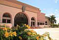
The Guayama Convention Center
-
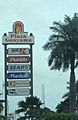
Plaza Guayama Mall
-
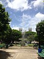
The central plaza and church of San Antonio de Padua in Guayama
-
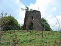
Sugar mill ruins in Guayama


See also
 In Spanish: Guayama para niños
