
Ciudad Guayana facts for kids
Quick facts for kids
Ciudad Guayana
|
||
|---|---|---|

Aerial view of Ciudad Guayana
|
||
|
||
.svg)
Ciudad Guayana
Location in Venezuela
|
||
| Country | ||
| State | Bolívar | |
| Founded | July 2, 1961 | |
| Area | ||
| • Total | 378.59 km2 (146.17 sq mi) | |
| Population
(2022)
|
||
| • Total | 950,000 | |
| • Demonym | guayanés | |
| Time zone | UTC−4 (VET) | |
| Area code(s) | 0286 | |
| Climate | Aw | |

Ciudad Guayana (which means Guayana City) is a large city in Bolívar State, Venezuela. It stretches for about 40 kilometers along the south bank of the Orinoco River. This is where the Caroní River, its main branch, joins it. The Caroní River flows through the city, dividing it into two main parts. The older part, called San Félix, is to the east. The newer area, Puerto Ordaz, is to the west.
Ciudad Guayana was officially created in 1961. It was formed by joining two older towns. However, the history of San Félix goes back to the 1700s. Inside the city, you can find beautiful places like Cachamay Falls and Llovizna Falls. There are three bridges over the Caroní River. Another big bridge, the Orinoquia Bridge, crosses the Orinoco River. It opened in 2006.
With almost one million people, Ciudad Guayana is one of Venezuela's fastest-growing cities. It is very important for industries like iron, steel, aluminum, and hydroelectric power. It is also a key shipping location. Ships can easily reach its port from the Atlantic Ocean using the Orinoco River. This makes it important for moving goods from Bolívar state.
Because Ciudad Guayana was carefully planned, it feels different from many other cities in South America. Some parts, like Alta Vista, look like modern cities. Many neighborhoods have homes and gardens that remind people of suburbs in the United States from the 1950s to 1980s. This is partly because US Steel, an American company, had iron operations here in the 1960s and 70s. They built homes for their workers in Puerto Ordaz.
Ciudad Guayana is in a very important spot in Venezuela. Many famous people have visited, from Pope John Paul II to former American presidents like G.W. Bush. Musicians, artists, and even filmmakers like Steven Spielberg have also come. They used the city's beautiful parks and scenery for movies. The city is served by Manuel Carlos Piar International Airport in Puerto Ordaz.
Contents
A Look at Ciudad Guayana's Past
The first explorations in this area happened in 1531. An expedition led by Juan González Sosa found new jungles and plains along the Orinoco River. Later, in 1591, Antonio de Berrio founded Santo Tome de Guayana. This first city was located where the Caroní and Orinoco rivers meet.
The city had to be founded again many times in different places. This was because of constant attacks from pirates and conquerors. They would destroy the city while searching for the legendary El Dorado. For example, in 1618, an English expedition led by Walter Raleigh completely destroyed the city. In 1764, people moved to Angostura (now Ciudad Bolivar) to escape these attacks. The city was finally founded in its current location on July 2, 1961. It was then named Ciudad Guayana.
For the city's design, the Corporacion Venezolana de Guayana asked for help from Harvard–MIT. They planned many highways, homes, schools, hospitals, and parks. This building effort has continued strongly since 1961. The goal is for the city to house 2.5 million people by 2020. Since 1961, Ciudad Guayana has been known as one of the fastest-growing cities in the world.
The Puerto Ordaz area was built and planned by companies like Orinoco Mining Company in the mid-1900s. On November 13, 2006, the Orinoquia Bridge opened. It is the second-largest bridge in Venezuela. This bridge makes it easier to travel between Ciudad Guayana and the other side of the Orinoco River.
Where is Ciudad Guayana?
The city is located where the Caroní and Orinoco River meet. It sits on a high plain about 200-300 feet above sea level.
Ciudad Guayana is hot and humid for most of the year. It has a tropical savanna climate (Köppen: Aw). There is a dry season from January to March.
| Climate data for Ciudad Guayana | |||||||||||||
|---|---|---|---|---|---|---|---|---|---|---|---|---|---|
| Month | Jan | Feb | Mar | Apr | May | Jun | Jul | Aug | Sep | Oct | Nov | Dec | Year |
| Record high °C (°F) | 35.5 (95.9) |
36.5 (97.7) |
39.3 (102.7) |
40.4 (104.7) |
38.7 (101.7) |
38.8 (101.8) |
37.6 (99.7) |
37.2 (99.0) |
39.5 (103.1) |
41.0 (105.8) |
39.5 (103.1) |
38.4 (101.1) |
41.0 (105.8) |
| Mean daily maximum °C (°F) | 31.8 (89.2) |
33.1 (91.6) |
34.3 (93.7) |
34.9 (94.8) |
33.6 (92.5) |
31.7 (89.1) |
31.0 (87.8) |
31.8 (89.2) |
32.9 (91.2) |
34.2 (93.6) |
35.4 (95.7) |
33.8 (92.8) |
33.2 (91.8) |
| Mean daily minimum °C (°F) | 22.2 (72.0) |
22.3 (72.1) |
22.9 (73.2) |
23.7 (74.7) |
25.2 (77.4) |
25.5 (77.9) |
26.1 (79.0) |
25.6 (78.1) |
25.9 (78.6) |
25.3 (77.5) |
23.8 (74.8) |
22.6 (72.7) |
24.3 (75.7) |
| Record low °C (°F) | 17.0 (62.6) |
15.2 (59.4) |
15.9 (60.6) |
15.4 (59.7) |
16.3 (61.3) |
17.1 (62.8) |
19.6 (67.3) |
18.1 (64.6) |
17.5 (63.5) |
16.7 (62.1) |
16.2 (61.2) |
15.7 (60.3) |
15.2 (59.4) |
| Average rainfall mm (inches) | 27.9 (1.10) |
17.8 (0.70) |
12.7 (0.50) |
83.8 (3.30) |
243.84 (9.60) |
305.8 (12.04) |
210.2 (8.28) |
162.6 (6.40) |
132.1 (5.20) |
73.6 (2.90) |
78.7 (3.10) |
53.3 (2.10) |
1,402.34 (55.22) |
| Average relative humidity (%) | 77.4 | 74.6 | 72.8 | 74.5 | 78.8 | 81.2 | 80.4 | 78.1 | 76.0 | 75.9 | 74.6 | 75.7 | 76.7 |
| Source: Instituto Nacional de Meteorología e Hidrología (INAMEH) | |||||||||||||
What Industries are in Ciudad Guayana?
Many of Venezuela's most important industries are located in Puerto Ordaz. These include companies that make aluminum, like Alcasa, Venalum, Bauxilum, and Carbonorca. There's also Ferrominera, which processes iron ore, and Sidor, a steelmaking company.
The country's main electricity producer, Corpoelec, is also here. The regional development office, CVG (Corporación Venezolana de Guayana), is located in Puerto Ordaz too.
Busy Ports
The port of Puerto Ordaz has many piers. Most of them are used by the CVG production companies, especially for aluminum. Two of the busiest piers are Ferrominera and Ternium Sidor.
Hydroelectric Power
Ciudad Guayana is home to the main office of CVG Electrificación del Caroní (CVG Edelca). This company is Venezuela's biggest producer of electricity. They manage several hydroelectric power plants along the Caroní River. Two of these, Macagua and Caruachi, are right within the city limits.
Macagua is easy to get to from the city center. It's a popular spot for tourists and for learning. There's even a public park and museum there. Edelca also built and manages two more dams upstream from the city: Tocoma and Guri. The Guri Dam is one of the largest hydroelectric power stations in the world. It created the Guri reservoir, which is the second-biggest lake in Venezuela.


Getting Around Ciudad Guayana
Puerto Ordaz has many large avenues that cross the city. Some of the main ones are:
- Guayana Avenue — This is the city's main road. It goes through Puerto Ordaz from beginning to end. It passes industrial areas, the airport, shopping centers, homes, and Parque Cachamay.
- Atlántico Avenue — This road runs from west to east on the south side of the city. It connects with other important avenues.
- Las Américas Avenue — This avenue links the Altavista area (north of the city) with the city center.
- Paseo Caroní Avenue — This road starts on the west side of the city and ends at Atlántico Avenue.
On December 3, 2006, the Orinoquia Bridge opened. This bridge crosses the Orinoco River, making travel easier. The city is also served by the Manuel Carlos Piar Guayana Airport.
Fun Things to Do in Ciudad Guayana
In Puerto Ordaz, there are many places for recreation:
- Natural Parks: Llovizna park, Cachamay park, and Loefling park are beautiful natural spots.
- Shopping Centers: You can visit Orinokia Mall, Altavista Mall, and Atlántico Mall for shopping.
- Family Fun: The Macagua Eco Museum, Christmas Park, and the Italian-Venezuelan Club offer family activities.
Ciudad Guayana is also home to two football (soccer) clubs: LALA FC and Mineros de Guayana. Both teams play their home games at the CTE Cachamay stadium. This stadium also hosts games for the national team and many concerts.
Famous People from Ciudad Guayana
- Kervin Andrade (born 2005), a Venezuelan footballer
- Eugenio Suárez (born 1991), a Major League Baseball player
- Freddy Fermin (born 1995), a Major League Baseball player
Learning in Ciudad Guayana
Puerto Ordaz is known for having one of the best engineering schools in Latin America. Here are some of the main universities:
Regional Universities:
- Andrés Bello UCAB (Catholic University)
- UDO (East University)
- Gran Mariscal de Ayacucho (UGMA) University
- Bicentenaria de Aragua (UBA) University
Puerto Ordaz also has these colleges:
- UNEXPO (National Experimental Polytechnic University)
- UNEG (National Experimental University of Guayana)
Technical Institutes:
- U.E.E.T.I. Fundación "La Salle" (San Félix)
- I.U.T. Antonio José de Sucre
- I.U.T. Pedro Emilio Coll
- I.U.P. Santiago Mariño
Exploring Ciudad Guayana

Inside the city, you can visit the Llovizna and Cachamay Parks to see their beautiful waterfalls. Another local attraction is the Caroní Ecomuseum at the Macagua Dam. Near the city, you can see where the Caroní and Orinoco rivers meet. The different colors of their waters create a clear line where they join.
From Puerto Ordaz, you can also visit the Orinoco Delta, Canaima National Park, and the Guri reservoirs. Other interesting places include the old colonial castles along the Orinoco River and the "Cerro del Elefante" (Elephant's hill), which you can reach with a 4x4 vehicle. The Castles of Guayana are located on the right side of the Orinoco River, about 35 kilometers from San Félix.
Images for kids
-
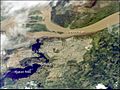
Guayana City from space
-
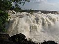
La Llovizna Falls
-
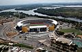
Football stadium Polideportivo Cachamay


See also
 In Spanish: Ciudad Guayana para niños
