
Machete, Guayama, Puerto Rico facts for kids
Quick facts for kids
Machete
|
|
|---|---|
|
Barrio
|
|

Near Highway 54 junction in Machete
|
|

Location of Machete within the municipality of Guayama shown in red
|
|

Machete, Guayama, Puerto Rico
Location in Caribbean
|
|
| Commonwealth | |
| Municipality | |
| Area | |
| • Total | 4.04 sq mi (10.5 km2) |
| • Land | 3.51 sq mi (9.1 km2) |
| • Water | 0.53 sq mi (1.4 km2) |
| Elevation | 52 ft (16 m) |
| Population
(2010)
|
|
| • Total | 3,846 |
| • Density | 1,095.7/sq mi (423.1/km2) |
| Source: 2010 Census | |
| Time zone | UTC−4 (AST) |
| ZIP Code |
00784
|
Machete is a small community, also known as a barrio, located in the town of Guayama, Puerto Rico. In 2010, about 3,846 people lived there.
A Look Back: Machete's History
Machete has a long history. Back in 1770, this area was part of the land ruled by caciques Güamaní and Guayama. A cacique was a leader or chief of the native Taíno people in the Caribbean.
Later, in the 1800s, Machete became very important for producing sugar. This was a major crop in Puerto Rico at the time.
After the Spanish–American War, Spain gave Puerto Rico to the United States. This happened in 1898 under the Treaty of Paris of 1898. Puerto Rico then became an unincorporated territory of the United States. This means it is a part of the U.S. but does not have all the same rights as a state.
In 1899, the United States government counted the people living in Puerto Rico. This count, called a census, showed that 368 people lived in Machete barrio. The population has grown quite a bit since then!
| Historical population | |||
|---|---|---|---|
| Census | Pop. | %± | |
| 1900 | 368 | — | |
| 1980 | 748 | — | |
| 1990 | 902 | 20.6% | |
| 2000 | 2,509 | 178.2% | |
| 2010 | 3,846 | 53.3% | |
| U.S. Decennial Census 1899 (shown as 1900) 1910-1930 1930-1950 1980-2000 2010 |
|||
Gallery
-
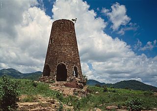
Hacienda Azucarera Vives in Machete
.jpg)
See also
 In Spanish: Machete (Guayama) para niños
- List of communities in Puerto Rico
