
Yabucoa, Puerto Rico facts for kids
Quick facts for kids
Yabucoa
Municipio Autónomo de Yabucoa
|
|||
|---|---|---|---|
|
Town and Municipality
|
|||

Statue representing Puerto Rican soldier who fought in Vietnam / Korea, in front of a government building
|
|||
|
|||
| Nicknames:
"Ciudad del Azúcar", "El Pueblo de Yuca", "Los Bebe Leche"
|
|||
| Anthem: "Yabucoa es mi Pueblo" | |||

Map of Puerto Rico highlighting Yabucoa Municipality
|
|||
| Sovereign state | |||
| Commonwealth | |||
| Founded | October 3, 1793 | ||
| Founded by | Carlos Morales | ||
| Barrios | |||
| Area | |||
| • Total | 83.26 sq mi (215.65 km2) | ||
| • Land | 55.26 sq mi (143.11 km2) | ||
| • Water | 28.01 sq mi (72.55 km2) | ||
| Population
(2020)
|
|||
| • Total | 30,426 | ||
| • Rank | 40th in Puerto Rico | ||
| • Density | 365.421/sq mi (141.090/km2) | ||
| Demonym(s) | Yabucoeños | ||
| Racial groups | |||
| • White | 68.5% | ||
| • Black | 8.6% | ||
| • American Indian/AN | 0.6% | ||
| • Asian | 0.3% | ||
| • Other Two or more races |
13.6% 8.2% |
||
| Time zone | UTC−4 (AST) | ||
| ZIP Code |
00767
|
||
| Area code(s) | 787/939 | ||
| Major routes | |||


Yabucoa (pronounced ya-boo-KO-ah) is a town and municipality in Puerto Rico. It is located in the eastern part of the island. Yabucoa is north of Maunabo and south of San Lorenzo, Las Piedras, and Humacao. It is also east of Patillas.
The town of Yabucoa is divided into 9 areas called barrios, plus the downtown area known as Yabucoa Pueblo. It is part of the larger San Juan-Caguas-Guaynabo Metropolitan Statistical Area.
Contents
What's in a Name?
The name Yabucoa might come from the Taíno language, which was spoken by the native people of Puerto Rico. Some believe it comes from Guaroca, meaning "where water is found."
However, many experts think it's more likely from the Taíno word yaucoa. This word means "cassava plantation." Cassava is a root vegetable, also known as yuca.
Fun Nicknames for Yabucoa
Yabucoa has a few cool nicknames:
- "Sugar City" is one nickname. This is because there used to be many sugarcane farms in the Yabucoa Valley.
- "Pueblo de Yuca" means "Yuca Town." This nickname also points to the Taíno origin of the town's name, linked to the cassava plant.
- Locals are sometimes called the "Bebe Leches" or "milk drinkers." This is because there are many dairy farms in the area.
Yabucoa's History
The area where Yabucoa is now was once part of the Taíno region called Guayaney. A Taíno leader named Cacique Guaraca ruled this land.
After the Spanish arrived, the Yabucoa region became part of Humacao. It was mostly used for raising cattle and farming. Yabucoa officially became a town on October 3, 1793. Don Manuel Colón de Bonilla and his wife, Doña Catalina Morales Pacheco, gave the land to the people.


Hurricane Maria's Impact
On September 20, 2017, Hurricane Maria hit Puerto Rico very hard. It was a strong Category 4 hurricane. The storm first made landfall in Camino Nuevo, Yabucoa.
The hurricane caused many problems:
- It knocked out electricity for the entire island.
- Access to clean water was also affected.
- There were many landslides, which are when large amounts of earth move down a slope.
- Widespread flooding occurred.
- Important buildings and roads were badly damaged.
Yabucoa's government buildings were heavily damaged. About 2,500 other buildings in Yabucoa were also affected. Many elderly people in Yabucoa were greatly affected. Sadly, some passed away due to the lack of electricity for medical equipment. A new section was added to the cemetery after the hurricane.
Even eight months after the hurricane, many homes in Yabucoa still did not have electricity. The mayor, Rafael Surillo, said that over 30% of homes were without power in June 2018. Some areas, like Jácanas, had no power for nine months.
Yabucoa's Geography
Yabucoa is located on the southeastern coast of Puerto Rico. The Valley of Yabucoa is special. It is surrounded by hills on three sides and the Caribbean Sea on the fourth.
The hills around Yabucoa are part of the San Lorenzo Batholith. This is a large rock formation. The highest point in the hills around Yabucoa is about 2,130 feet (649 meters) high. The valley itself gently slopes down to the sea.
Barrios of Yabucoa

Like all municipalities in Puerto Rico, Yabucoa is divided into smaller areas called barrios. The main town area, with government buildings and the church, is called "el pueblo".
Here are the barrios in Yabucoa:
- Aguacate
- Calabazas
- Camino Nuevo
- Guayabota
- Jácanas
- Juan Martín
- Limones
- Playa
- Tejas
- Yabucoa barrio-pueblo
Sectors
Barrios are further divided into even smaller areas called sectores (sectors). These can have different names like urbanización or residencial.
Special Communities
Some communities in Puerto Rico are called Comunidades Especiales (Special Communities). These are areas where people might face challenges and need extra support. In Yabucoa, some of these communities include Ingenio, Jacanas Granja, Playa Guayanés, Tejas Trinidad, and Urbanización Jaime C. Rodríguez.
Population of Yabucoa
| Historical population | |||
|---|---|---|---|
| Census | Pop. | %± | |
| 1900 | 13,905 | — | |
| 1910 | 17,338 | 24.7% | |
| 1920 | 19,623 | 13.2% | |
| 1930 | 21,914 | 11.7% | |
| 1940 | 27,438 | 25.2% | |
| 1950 | 28,810 | 5.0% | |
| 1960 | 29,782 | 3.4% | |
| 1970 | 30,165 | 1.3% | |
| 1980 | 31,425 | 4.2% | |
| 1990 | 36,483 | 16.1% | |
| 2000 | 39,246 | 7.6% | |
| 2010 | 37,941 | −3.3% | |
| 2020 | 30,426 | −19.8% | |
| U.S. Decennial Census 1899 (shown as 1900) 1910-1930 1930-1950 1960-2000 2010 2020 |
|||
Fun Things to Do in Yabucoa
Yabucoa has many interesting places to visit:
- Guayanés Beach and pier
- Kyle Rembis beach
- Hacienda Santa Lucía Ruins (old sugar plantation ruins)
- La Casa de la Cultura (House of Culture)
- Roig Refinery (an old sugar refinery)
- El Cocal Beach, also known as El Guano Beach
- Public skatepark
- Playa Lucia (Dead Dog Beach)
- Petroleum Refinery
- Punta Yeguas (a nature reserve)
Yabucoa's Economy
Farming and Industry

Yabucoa is known for its farming. The fertile valley grows most of the island's plantains and bananas. People from Yabucoa are sometimes called "sugar people." This is because much of the valley was used for growing sugar cane.
One of the most famous sights in Yabucoa is the old Hacienda Roig sugar mill. It was one of the last mills in Puerto Rico to produce sugar.
There is also a special company in Yabucoa called Olein Recovery Corp. It is the only oil recycling company in the Caribbean. During the COVID-19 pandemic, Olein started making hand sanitizer.
Culture and Celebrations

Festivals and Events
Yabucoa celebrates its patron saint festival in September or October. This festival is called the Fiestas Patronales de los Santos Angeles Custodios. It's a fun religious and cultural event with parades, games, local crafts, rides, food, and live music.
Other festivals and events in Yabucoa include:
- Sugar Cane Festival - May
- Beach Festival - May
- Festival del Carmen – July
- Campesino Festival – October
- Jíbaro de Martorell Festival – December
Community events and concerts are often held at the Concha Acústica Toño Márquez.
Sports

The Azucareros de Yabucoa are Yabucoa's Double-A baseball team. They have won 4 championships!
- In 1994, they won against the Toritos de Cayey.
- In 1995, they won against Cidra.
- In 1996, they won against Cabo Rojo.
In 2020, the Azucareros de Yabucoa became the eighth Puerto Rico Double-A baseball team to win 900 games.
Their home stadium, the Estadio Félix "Nacho" Millán, was badly damaged by Hurricane Maria in 2017. As of 2020, the stadium still needed repairs.
Symbols of Yabucoa
The municipality of Yabucoa has its own official flag and coat of arms.
The Flag
The flag of Yabucoa has an abstract design. Its colors, green, white, and violet, are inspired by the municipal shield.
The Coat of Arms
The shield shows two angels, the Santos Angeles Custodios. These are the patron saints of Yabucoa. The color purple (violet) on the shield represents the high importance of the angels.
The walking sticks on the shield represent travelers. They show the angels' role as guides and companions for people on their journey through life. The sticks are decorated with guajana flowers, which symbolize the rich sugar cane crops. The green land where the angels stand represents the fertile valley where Yabucoa is located.
Getting Around Yabucoa
One of the main roads to Yabucoa is PR-3. This road runs along the eastern side of the island. Yabucoa is about an hour's drive from the capital city.
In 2008, a tunnel was finished that connects Yabucoa with the town of Maunabo. This tunnel is currently the longest on the island.
Yabucoa also has 41 bridges.
Famous People from Yabucoa
Many notable people come from Yabucoa:
- Nydia Velasquez - A congresswoman in the United States.
- Carmen Delgado Votaw (1935–2017) - A civil rights activist.
- Christian Pagán - The winner of Idol Puerto Rico.
- Santiago Vidarte (1828–1848) - A poet.
- Antonio Ayuso Valdivieso (1899–1969) - A politician, lawyer, and educator.
- Jose Facundo Cintrón - He worked to end slavery in 1872 and 1873.
- Emilio Diaz Colon - A member of the military.
- Luis Diaz Colon - A politician and former mayor of Yabucoa.
- Jordan A. Caraballo-Vega - A Computer Engineer who works for NASA.
Many people from Yabucoa have also served in the U.S. military.
Images for kids
-
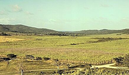
Sugarcane field in Yabucoa in 1941
-
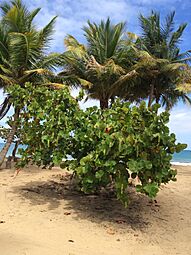
Seagrape shrub at Playa Lucia in 2015
-
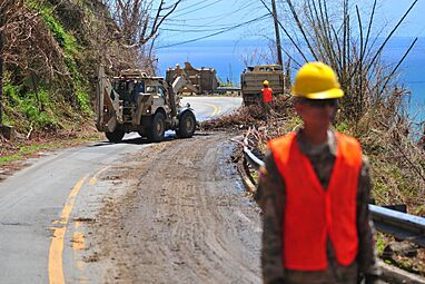
National Guard clearing debris in Yabucoa after Hurricane Maria in 2017
-
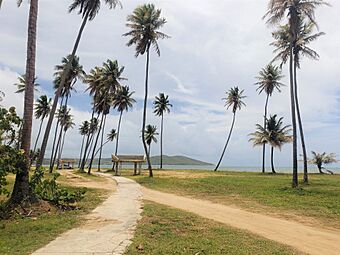
Playa Lucia in Yabucoa in 2020

_shrub_at_Playa_Lucia,_Yabucoa,_Puerto_Rico.jpg)
.jpg)

See also
 In Spanish: Yabucoa para niños
