
Maunabo, Puerto Rico facts for kids
Quick facts for kids
Maunabo
Municipio Autónomo de Maunabo
|
|||
|---|---|---|---|
|
Town and Municipality
|
|||

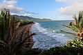
The coastline of Maunabo
|
|||
|
|||
| Nicknames:
"La Ciudad Tranquila", "Los Jueyeros", "Los Come Jueyes"
|
|||
| Anthem: "Maunabo pueblito del sureste de mi amada patria Borinquén" | |||

Map of Puerto Rico highlighting Maunabo Municipality
|
|||
| Sovereign state | |||
| Commonwealth | |||
| Founded | March 9, 1799 | ||
| Founded by | Don Luis de Santiago | ||
| Barrios | |||
| Area | |||
| • Total | 27.88 sq mi (72.21 km2) | ||
| • Land | 21 sq mi (55 km2) | ||
| • Water | 6.64 sq mi (17.21 km2) | ||
| Population
(2020)
|
|||
| • Total | 10,589 | ||
| • Rank | 74th in Puerto Rico | ||
| • Density | 379.80/sq mi (146.642/km2) | ||
| Demonym(s) | Maunabeños | ||
| Time zone | UTC−4 (AST) | ||
| ZIP Code |
00707
|
||
| Area code(s) | 787/939 | ||
| Major routes | |||


Maunabo (pronounced maw-NAH-boh) is a town and municipality in Puerto Rico. It is located on the southeastern coast, nestled in the Maunabo Valley. Maunabo is northeast of Patillas and south of Yabucoa.
The town is part of the San Juan-Caguas-Guaynabo Metropolitan Statistical Area. In 2020, its population was 10,589 people. The current mayor of Maunabo is Ángel Omar Lafuente Amaro.
Contents
History of Maunabo
How Maunabo Got Its Name
Maunabo was founded in 1799. Its name comes from a Taíno word, Manatuabón. This was the name for the Maunabo River. The Taíno were the native people of Puerto Rico.
Early Days and Challenges
Life was tough for the first settlers in Maunabo. In 1800, only 712 people lived there. About 180 of them were enslaved people.
People mostly farmed to feed themselves and their animals. They grew small fruits and crops. The town center was small, with only 30 houses and 15 huts in 1824.
A port was built in 1812 to trade with nearby towns and Saint Thomas. But tropical storms often destroyed the wooden port. Hurricanes in 1825 and 1827 ruined farms and homes. People also faced droughts and diseases like smallpox.
The first church, San Isidro Labrador y Santa Maria de la Cabeza, was built in 1799. The Casa del Rey was where the local government met.
The Sugar Industry's Influence
In the 1800s and early 1900s, sugar was very important to Maunabo. Three big sugar farms were called Garonne, Bordelaise, and Orleanaise. French families started these farms in the 1840s.
Many enslaved Afro-Puerto Ricans were forced to work on these farms. By 1869, over 250 enslaved people were recorded in Maunabo. After slavery ended in 1873, sugar farming became less profitable.
After the United States took over Puerto Rico in 1898, sugar production grew. This lasted even through the Great Depression.
The Central Columbia Sugar Factory
After a big hurricane in 1899, the owners of the three largest sugar farms teamed up. They built a modern sugar factory called The Central Columbia Sugar Company. It opened in 1901.
The factory was located by the Maunabo River. In its first harvest, it produced 20,000 sacks of sugar. This was the fifth highest amount on the island.
The Central Columbia was important for Maunabo's economy. But another hurricane in 1928 destroyed it. After that, Maunabo's sugar was processed at a factory in Arroyo.
The old factory site was then used for trucking sugar. Today, the ruins of the Central Columbia are a famous landmark in Maunabo.
.png)
Puerto Rico Becomes a U.S. Territory
After the Spanish–American War in 1898, Spain gave Puerto Rico to the United States. In 1899, a census showed Maunabo had 6,221 people.
Maunabo's Local Newspaper
Maunabo is known for its local media. Because high mountains separated the town, people started their own newspaper. It was called La Esquina (meaning "The Corner").
It began on August 30, 1975, by Ramón "Chito" Arroyo and José Orlando Rivera. It was a free, one-page paper for the community. It became so popular that it turned into a monthly tabloid.
Today, La Esquina is still free. It delivers 40,000 copies to Maunabo and nearby towns. More than 190,000 people read it.
Hurricane Maria's Impact
On September 20, 2017, Hurricane Maria hit Puerto Rico. The hurricane brought strong winds and heavy rain to Maunabo. This caused many landslides.
The electric company said it could take up to nine months to get power back. The mayor reported that all small businesses were affected. Also, all the small fruit crops were lost.
Geography and Nature
Maunabo's Mountains
Maunabo is surrounded by tall mountains on two sides. The three main peaks are:
- Pico Hutton on Sierra de Guardarraya, which is 1,799 feet (548 m) high.
- Cerro Santa Elena, also called El Sombrerito (the "little hat"), on Sierra Pandura. It is 1,722 feet (525 m) high.
- Cerro de la Pandura, which is 1,692 feet (516 m) high.
The wind on these high mountains is very strong. At Sierra Guardarraya, the strong winds make the tall grass grow flat to the ground.
The Coquí Guajón Frog
In the green, tropical mountains of Cerro de la Pandura, you can find a special frog. It is one of Puerto Rico's most endangered species of coquí. This frog is called the coquí Guajón (Eleutherodactylus cooki).
It lives in the mountains shared by Yabucoa, Patillas, and San Lorenzo. The U.S. Fish and Wildlife Service declared it an endangered species in 1997.
Maunabo's Barrios and Sectors

Like all municipalities in Puerto Rico, Maunabo is divided into areas called barrios. The main town area, with municipal buildings and the church, is called "el pueblo".
Here are Maunabo's barrios:
- Calzada
- Emajagua
- Lizas
- Matuyas Alto
- Matuyas Bajo
- Maunabo barrio-pueblo
- Palo Seco
- Quebrada Arenas
- Talante
- Tumbao
Barrios are further divided into smaller areas called sectores (sectors). These can be called urbanización, reparto, or barriada.
Special Communities
Some communities in Puerto Rico are called Comunidades Especiales (Special Communities). These are areas where citizens face challenges. In Maunabo, these include Matuyas, Sector García in Talante, and Batey Columbia in Calzada.
Demographics
| Historical population | |||
|---|---|---|---|
| Census | Pop. | %± | |
| 1900 | 6,221 | — | |
| 1910 | 7,106 | 14.2% | |
| 1920 | 7,973 | 12.2% | |
| 1930 | 9,084 | 13.9% | |
| 1940 | 10,792 | 18.8% | |
| 1950 | 11,758 | 9.0% | |
| 1960 | 10,785 | −8.3% | |
| 1970 | 10,792 | 0.1% | |
| 1980 | 11,813 | 9.5% | |
| 1990 | 12,347 | 4.5% | |
| 2000 | 12,741 | 3.2% | |
| 2010 | 12,225 | −4.0% | |
| 2020 | 10,589 | −13.4% | |
| U.S. Decennial Census 1899 (shown as 1900) 1910-1930 1930-1950 1960-2000 2010 2020 |
|||
Tourism and Attractions

Maunabo has a special charm because it's separated by mountains. It doesn't have many big chain stores, which gives it a unique feel.
Beautiful Beaches
Maunabo's warm, clear blue and green beaches are a big draw. The three main beaches are Los Bohios, Los Pinos, and Playa Punta Tuna. Locals visit them all year.
Tourists who want to explore beyond San Juan also come here. Surfers enjoy the wild waters.
Playa Punta Tuna is also known as Playa Escondida, or "hidden beach." It has the Punta Tuna Lighthouse on one side. Lush sea grape trees hide it from the main road. You can only reach it by walking a short, dusty path.
Los Pinos Beach has sand that shines with black minerals. Legend says these come from sea volcanoes. These minerals stick to wet things, so fewer people visit this beach. Los Bohios Beach is also very popular.
Punta Tuna Lighthouse

The Punta Tuna Lighthouse was built by the Spanish in 1892. This was before Puerto Rico became a U.S. territory. It has always been working, managed by the U.S. Coast Guard.
For almost 30 years, people couldn't visit the lighthouse. But in February 2006, its doors opened to the public again. The lighthouse is also a symbol on Maunabo's coat of arms.
Annual Crab Carnival
Maunabo is famous for its yearly crab carnival, "Festi-Carnaval Jueyero." Thousands of visitors come for this three-day event. It features live music, street fairs, contests, and lots of crab dishes. The carnival happens in the first week of September, during the hottest part of summer.
Other Landmarks to Explore
- Cantera Caverns
- Sierra Pandura
- The ruins of the Central Columbia sugar factory
Culture and Celebrations
Festivals and Events in Maunabo
Maunabo celebrates its patron saint festival in May. The Fiestas Patronales San Pedro y San Isidro Labrador is a religious and cultural event. It usually includes parades, games, local crafts, rides, food, and live shows.
Other fun festivals and events in Maunabo include:
- Gifts on the eve of Three Kings Day (Entrega de Regalos en la Víspera de Reyes) – January
- Isidore, the Farmer Community Festival (Festival Comunitario San Isidro Labrador) – May
- Town Festival (Fiestas de Pueblo) – June/July
- Festival of Our Lady of Mount Carmel (Fiesta del Carmen) – July
- Night Out (Noche de Afuera) – August
- Land Crab Festival and Carnival (Festi- carnaval Jueyero) – September
- Christmas Party at Calle 3 (Palo Seco) (Fiestón Navideño en la Calle 3 (Palo Seco)) – December
- Aníbal Arroyo Cup (basketball event) (Copa Aníbal Arroyo (evento de baloncesto)) – December
- End of Year Marathon (Maratón Año Viejo) – December 31
Economy and Industry
The Comité Pro Desarrollo de Maunabo (Committee for the Development of Maunabo) works to improve the town. In 2018, they helped upgrade Casa Verde, a place for hurricane relief.
What Maunabo Produces
- Agriculture: Fruits, vegetables, and cattle.
- Industry: Fishing, guitar strings, and plantains.
Symbols of Maunabo
Maunabo has an official flag and a coat of arms.
Maunabo's Flag
The flag of Maunabo is green with a white stripe going across it diagonally. In the corners of the green triangles, there are two yellow ox yokes.
Maunabo's Coat of Arms
The main colors of the shield are silver and green. These colors represent sugarcane fields. The upside-down V shape stands for Maunabo's mountains: Sierra de Guarderraya and Sierra de la Pandura.
A lighthouse on the shield represents the Punta Tuna Lighthouse. This is Maunabo's oldest building. The yokes are symbols of farming and Maunabo's patron saint, San Isidro Labrador.
Transportation and Tunnels

Maunabo built a special tunnel that goes under a mountain. This tunnel connects Maunabo with the nearby town of Yabucoa.
The tunnels are named Vicente Morales Lebrón. He was an environmental activist. In 1956, a tropical storm damaged the only road connecting Maunabo to the north. Morales Lebrón suggested building the tunnels.
In September 2018, the tunnel was briefly closed. This was for filming a music video. Maunabo also has 22 bridges.
Notable Residents
- Zahimara Fantauzzi (born 1993), a footballer for the Puerto Rico women's national team.
- Heliot Ramos (born 1999), a baseball player for the San Francisco Giants.
- Rudolph W. Riefkohl (born 1895), a Colonel in the United States Army.
- Frederick L. Riefkohl (born 1889), a Rear Admiral in the United States Navy.
Images for kids
-
Punta Tuna Beach from Punta Tuna Lighthouse
-
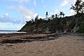
Punta Tuna Lighthouse at Punta Tuna Beach
-
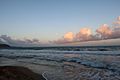
Punta Tuna Beach sky


See also
 In Spanish: Maunabo para niños
