
Mameyes Arriba facts for kids
Quick facts for kids
Mameyes Arriba
|
|
|---|---|
|
Barrio
|
|

Unpaved road in the mountains of Mameyes Arriba
|
|

Location of Mameyes Arriba within the municipality of Jayuya shown in red
|
|

Mameyes Arriba
Location in Caribbean
|
|
| Commonwealth | |
| Municipality | |
| Area | |
| • Total | 9.515 sq mi (24.64 km2) |
| • Land | 9.514 sq mi (24.64 km2) |
| • Water | 0.001 sq mi (0.003 km2) |
| Elevation | 1,696 ft (517 m) |
| Population
(2010)
|
|
| • Total | 2,240 |
| • Density | 235.3/sq mi (90.8/km2) |
| Source: 2010 Census | |
| Time zone | UTC−4 (AST) |
Mameyes Arriba (which means "Upper Mameyes" in Spanish) is a special kind of neighborhood, called a barrio. It is located in the beautiful mountains of Jayuya, Puerto Rico. In 2010, about 2,240 people lived there.
Where is Mameyes Arriba?
Mameyes Arriba is found in the central part of Puerto Rico. It is part of the Jayuya municipality, which is known for its green mountains and coffee farms. The area is quite high up, with an elevation of about 1,696 feet (517 meters) above sea level. This makes it a cool and scenic place.
How Many People Live Here?
The number of people living in Mameyes Arriba has changed over the years. For example, in 1930, there were 2,205 residents. By 2010, the population was 2,240. This shows that the number of people living in this mountain community has stayed fairly steady over time.
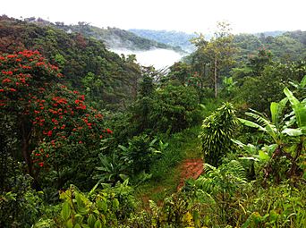
What Does it Look Like?
Mameyes Arriba is a very scenic place. It has winding roads and beautiful views of the mountains. You can often see clouds resting on the peaks, making the landscape look very dramatic and peaceful.
-
Mountains and clouds in Mameyes Arriba

Learn More!
If you want to learn even more about Mameyes Arriba, you can check out this page in Spanish:  Mameyes Arriba (Jayuya) para niños
