
Cerro de Punta facts for kids
Quick facts for kids Cerro de Punta |
|
|---|---|
.jpg)
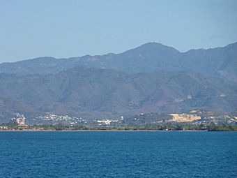
Cerro de Punta as seen from Museo de Arte de Ponce, Ponce, Puerto Rico
|
|
| Highest point | |
| Elevation | 4,390 ft (1,340 m) |
| Prominence | 4,390 ft (1,340 m) |
| Listing |
|
| Geography | |

Cerro de Punta
Location in Puerto Rico
|
|
| Location | Ponce and Jayuya, Puerto Rico |
| Parent range | Cordillera Central |
| Climbing | |
| Easiest route | PR-143 |
Cerro de Punta, also known as Cerro Punta, is the tallest mountain in Puerto Rico. It reaches a height of about 4,390 feet (1,338 meters) above sea level. This impressive peak is part of the Cordillera Central, which is the main mountain range running through Puerto Rico. It is located where the towns of Ponce and Jayuya meet.
Contents
Where is Cerro de Punta Located?
Cerro de Punta is found in the Cordillera Central mountain range. It sits right on the border between the municipalities of Jayuya and Ponce. The easiest way to get close to the very top is from the Jayuya side.
This mountain is also part of the Toro Negro Forest Reserve. It's sometimes called an "alpine runt" because it's not as tall as some other famous mountains. You can find it on the western edge of the Toro Negro State Park. The mountain is just north of Route 143, a road that runs from east to west. Its exact location is at coordinates 18.172458N and -66.591839W. The closest town to Cerro de Punta is Urbanization Vega Linda, which is about 3.3 miles away.
How Was Cerro de Punta Formed?
Unlike many mountains in the Caribbean, Cerro de Punta is not a volcano. Instead, it is simply the highest point in the Cordillera Central. This central mountain range stretches across the island from east to west, dividing it.
Amazing Views from the Top

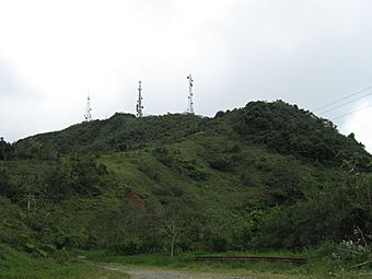
Many people say that the view from the top of Cerro de Punta is "the best view in all of Puerto Rico." On a clear day, you can see almost the entire island! You might even be able to spot San Juan, which is more than 75 miles away. There are also several radio and television towers near the summit. These towers help send signals across the island. There is a special platform at the very top where visitors can enjoy the incredible scenery.
Plants and Animals on the Mountain
Cerro de Punta is home to lots of different plants and animals. You'll find lush green plants, colorful flowering bushes and trees, and many beautiful waterfalls. The mountain is covered with palm trees.
Many types of plants grow here, including some that are rare. For example, a special kind of fern called Elaphoglossum serpens grows only on this mountain and nowhere else in the world!
| Weather chart for Cerro Puntas (Climate - Sub-Tropical Highland (Cfb)) | |||||||||||||||||||||||||||||||||||||||||||||||
|---|---|---|---|---|---|---|---|---|---|---|---|---|---|---|---|---|---|---|---|---|---|---|---|---|---|---|---|---|---|---|---|---|---|---|---|---|---|---|---|---|---|---|---|---|---|---|---|
| J | F | M | A | M | J | J | A | S | O | N | D | ||||||||||||||||||||||||||||||||||||
|
3.4
66
41
|
2.7
68
41
|
2.8
68
47
|
6.1
69
56
|
12
73
61
|
7.8
75
62
|
11
76
62
|
13
78
62
|
10
75
62
|
9.9
76
61
|
13
70
56
|
7.7
65
46
|
||||||||||||||||||||||||||||||||||||
| temperatures in °F precipitation totals in inches |
|||||||||||||||||||||||||||||||||||||||||||||||
|
Metric conversion
|
|||||||||||||||||||||||||||||||||||||||||||||||
Driving to Cerro de Punta

The area around Cerro de Punta has many steep mountains. The closest main road is PR-143. This is a winding, two-lane mountain road. You need to drive very slowly because it's hard to see cars coming from the other direction.
Off Route 143, there's a smaller road that goes directly to the mountain's summit. You can get to Route 143 from the larger Route 10. Route 143 is also part of the famous Ruta Panorámica, a scenic route across Puerto Rico.
Hiking and Trails

There's an inn nearby called Hacienda Gripiñas. This used to be a coffee plantation, but now it's a country inn. It still grows some coffee! The inn has a trail that leads to the top of Cerro de Punta. However, these trails are not always clearly marked and can get damaged by storms.
Even though you can hike to the top, there is also a paved road that goes all the way to the summit. The Toro Negro State Forest has 12 miles of hiking trails. Some of these trails also lead up to the top of Cerro de Punta.
Gallery
-
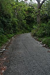
Paved road for climbing up to Cerro de Punta
-
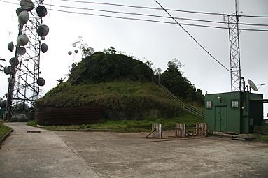
Antennas at Cerro de Punta
-
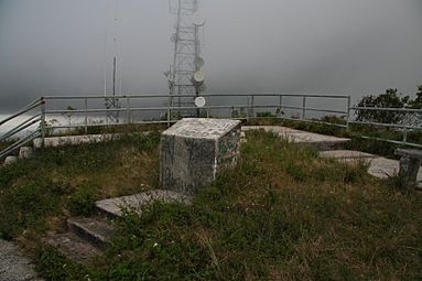
Lookout area at Cerro de Punta's summit
-
Cerro de Punta as seen from Mercedita Airport, Ponce, Puerto Rico
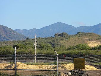
-
Cerro de Punta as seen from Caja de Muertos, Ponce, Puerto Rico
-
Cerro de Punta as viewed from Ruta Panorámica


.jpg)
.jpg)

See also
 In Spanish: Cerro de Punta para niños
