Coto Laurel facts for kids
Quick facts for kids
Coto Laurel
|
|
|---|---|

Puerto Rico Highway 506 in Coto Laurel
|
|

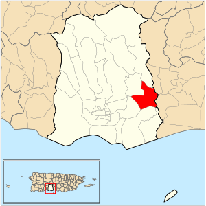
Location of barrio Coto Laurel within the municipality of Ponce shown in red
|
|
| Commonwealth | |
| Municipality | |
| Area | |
| • Total | 3.59 sq mi (9.3 km2) |
| • Land | 3.54 sq mi (9.2 km2) |
| • Water | 0.05 sq mi (0.1 km2) |
| Elevation | 335 ft (102 m) |
| Population
(2010)
|
|
| • Total | 7,123 |
| • Density | 2,023.6/sq mi (781.3/km2) |
| Source: 2010 Census | |
| Time zone | UTC−4 (AST) |
Coto Laurel is a special area, or barrio, in the city of Ponce, Puerto Rico. It's one of 31 barrios in Ponce. Coto Laurel is one of nine barrios that share a border with another town. It touches the nearby town of Juana Díaz. This barrio was first established way back in 1831.
Contents
Where is Coto Laurel Located?
Coto Laurel is a suburban barrio. It is found in the southeastern part of the city of Ponce. It sits east of the main city center, known as Plaza Las Delicias.
What Does the Name Coto Laurel Mean?
The name Coto Laurel has an interesting history. Coto in Spanish means a piece of land given to people. This land was often given for services they provided to the king. Laurel refers to laurel trees. So, the name likely means "land with laurel trees."
What are Coto Laurel's Borders?
Coto Laurel has natural and man-made borders. To the north, it is bordered by the Río Inabón river and Lake Number 5. To the south, Esperanza Street forms a boundary. On the west, PR-10 highway generally marks the edge. The Río Inabón river also forms the eastern border.
Neighboring Areas
Coto Laurel shares its borders with several other barrios. To the north, it touches Cerrillos and Real. To the south, it borders Vayas. On the west, it is next to Sabanetas and Cerrillos. Finally, to the east, it borders the municipality of Juana Díaz.
What is Coto Laurel Like?
Coto Laurel covers about 3.60 square miles (9.3 km2) of land. It also has a small water area of about 0.06 square miles (0.16 km2).
How Many People Live Here?
In the year 2000, about 5,285 people lived in Coto Laurel. This meant there were about 1,468 people for every square mile. By 2010, the population grew to 7,123 people. The population density also increased to about 2,023 people per square mile.
Communities and Roads
Several communities are part of Coto Laurel. These include Palmarejo, Llanos del Sur, and El Monte. Lake Giles is also located within Coto Laurel. Two important highways cross through the barrio. These are Puerto Rico's superhighway PR-52 and PR-14.
| Historical population | |||
|---|---|---|---|
| Census | Pop. | %± | |
| 1900 | 1,884 | — | |
| 1910 | 1,899 | 0.8% | |
| 1920 | 1,953 | 2.8% | |
| 1930 | 2,164 | 10.8% | |
| 1940 | 2,004 | −7.4% | |
| 1950 | 3,026 | 51.0% | |
| 1960 | 3,907 | 29.1% | |
| 1970 | 3,940 | 0.8% | |
| 1980 | 5,192 | 31.8% | |
| 1990 | 5,915 | 13.9% | |
| 2000 | 5,285 | −10.7% | |
| 2010 | 7,123 | 34.8% | |
| U.S. Decennial Census 1899 (shown as 1900) 1910-1930 1930-1950 1960 1980-2000 2010 |
|||
Important Places in Coto Laurel
Coto Laurel is home to some key landmarks. One is Industrias Vassallo, a large company. Another important place is Hospital San Cristobal. This is one of the biggest hospitals in Ponce. The village square in Coto Laurel was built in 1980. This happened when José G. Tormos Vega was the mayor.
See also
 In Spanish: Coto Laurel para niños
 | Madam C. J. Walker |
 | Janet Emerson Bashen |
 | Annie Turnbo Malone |
 | Maggie L. Walker |


