Jacaguas River facts for kids
Quick facts for kids Río Jacaguas |
|
|---|---|

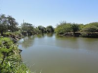
Río Jacaguas, as seen from Barrio Capitanejo, Juana Díaz, some 100 feet before it empties into the Caribbean Sea
|
|
| Lua error in Module:Location_map at line 420: attempt to index field 'wikibase' (a nil value).
Location of mouth
|
|
| Commonwealth | Puerto Rico |
| Physical characteristics | |
| Main source | Villalba 2,099 feet (640 m) 17°58′26″N 66°32′22″W / 17.9738553°N 66.5393380°W |
| River mouth | Caribbean Sea 0 feet (0 m) |
| Length | 24.68 miles (39.72 km) |
| Basin features | |
| Progression | Juana Diaz, Ponce |
| River system | Jacaguas River |
| Basin size | 59.85 sq mi (155.0 km2) |
| Tributaries |
|
The Río Jacaguas is an important river in Puerto Rico. It flows through two different areas: Ponce and Juana Díaz. This river starts in the mountains and flows south, eventually emptying into the warm Caribbean Sea.
The Río Jacaguas is special because it is the longest river in the Ponce area. It stretches for about 39.72 kilometers (or 24.68 miles). It also carries a lot of water, about 37,000 cubic feet every second! This makes it the most powerful river in Ponce.
Where the River Starts and Flows
The Jacaguas River begins its journey high up in the mountains of Villalba, Puerto Rico. It starts at a place where two areas, called Vacas and Hato Puerco Arriba, meet. This spot is about 2,099 feet (or 640 meters) above sea level.
As the river flows, it passes through Villalba and then Juana Díaz. Along its way, it helps form a lake called Guayabal Lake. After that, the river reaches the area of Ponce. For much of its path, the Río Jacaguas forms the natural border between Ponce and Juana Díaz. Finally, it completes its long journey by flowing into the Caribbean Sea.
See also
 In Spanish: Río Jacaguas para niños
 | Jessica Watkins |
 | Robert Henry Lawrence Jr. |
 | Mae Jemison |
 | Sian Proctor |
 | Guion Bluford |


