Cerrillos River facts for kids
Quick facts for kids Cerrillos River |
|
|---|---|

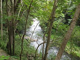
Cerrillos River near the Lake Cerrillos Dam
|
|
| Lua error in Module:Location_map at line 420: attempt to index field 'wikibase' (a nil value).
Location of mouth
|
|
| Other name(s) | Río Maragüez |
| Commonwealth | Puerto Rico |
| Municipality | Ponce |
| Physical characteristics | |
| Main source | Barrio Anón 1,200 feet (370 m) 18°07′55″N 66°34′48″W / 18.1319046°N 66.5798949°W |
| River mouth | Río Bucaná 69 feet (21 m) |
| Length | 18.5 miles (29.8 km) |
| Basin features | |
| Progression | Anón Maragüez Cerrillos |
| River system | Río Bucaná |
| Basin size | 17.80 sq mi (46.1 km2) |
| Tributaries |
|
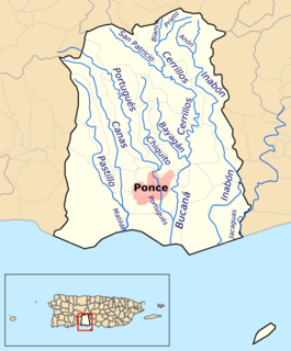
The Cerrillos River (in Spanish: Río Cerrillos) is a river found in the city of Ponce, Puerto Rico. It starts in an area called Barrio Anón. The river then flows south until it joins the Bucaná River. Many local people call it the Maragüez River. This is because a large part of its journey goes through Barrio Maragüez. The Cerrillos River is one of 14 rivers in the Ponce area. It carries a lot of water, about 24,000 cubic feet per second. This makes it the second biggest river in Ponce, after the Río Jacaguas.
Where Does It Flow?
The Cerrillos River begins in the mountains of Barrio Anón. It starts about 1 kilometer south of where two main roads, PR-139 and PR-143, meet. From there, it flows south for about 1.8 kilometers. Along the way, another river called Río Prieto joins it.
The Cerrillos River then flows next to PR-139 for 2 kilometers. This part of the river is still in Barrio Anón. After this, it enters Barrio Maragüez. It continues flowing south for about 1.2 kilometers. Here, the Río San Patricio adds its water to the Cerrillos River.
Forming Lake Cerrillos
About five kilometers further downstream, the Cerrillos River creates Lake Cerrillos. This lake is formed because of a large dam built across the river. After flowing out of the dam, the river continues south for 1 kilometer. It then becomes the natural border between two areas: Barrio Machuelo Arriba and Barrio Cerrillos.
The river keeps flowing south, parallel to PR-139, for another 5 kilometers. It passes near PR-5139. One kilometer downstream, a stream called Quebrada Ausubo joins it. Another kilometer further south, the Río Bayagán flows into the Cerrillos River. At this point, the Cerrillos River ends its journey by joining the Río Bucaná.
Lake Cerrillos and the Dam
The Cerrillos River is the main source of water for Lake Cerrillos. This lake is located in Barrio Maragüez, within the municipality of Ponce. Lake Cerrillos is an artificial lake, which means it was made by people. It can hold a huge amount of water: 47,900 acre-feet (that's about 59,100,000 cubic meters!).
The dam that created this lake was finished in 1992. The area around the lake is very beautiful. North of the dam, you'll find the Cerrillos State Forest. This is a protected forest area. Just south of the dam, there's a park called the Luis A. Wito Morales Park. It's a great place for people to visit and enjoy nature.
See also
 In Spanish: Río Cerrillos para niños
 | Aurelia Browder |
 | Nannie Helen Burroughs |
 | Michelle Alexander |


