
Cerrillos State Forest facts for kids
Quick facts for kids Cerrillos State ForestSpanish: Bosque Estatal de Cerrillos |
|
|---|---|

Picnic area at Cerrillos State Forest, PR-139, km 3.4
|
|
| Map | |

Location in Puerto Rico
|
|
| Geography | |
| Location | PR-139, km. 3.4 Ponce, Puerto Rico |
| Coordinates | 18°05′18″N 66°34′50″W / 18.08842°N 66.58058°W |
| Elevation | 1,000 feet (300 m) |
| Area | > 200 cuerdas (≈ 194 acres) |
| Administration | |
| Status | Public, State (Commonwealth) forest |
| Established | 25 September 1996 |
| Visitation | (2012) |
| Events | 1993 Central American and Caribbean Games 2010 Central American and Caribbean Games |
| Governing body | Puerto Rico Department of Natural and Environmental Resources |
| Ecology | |
| Ecosystem(s) | Subtropical Moist Zone (Zona Húmeda Subtropical): -Tabonuco forest (Bosque de Tabonuco). |
| WWF Classification | Puerto Rican moist forests |
| Disturbance | Hurricanes |
| Forest cover | 60% (approx.) |
Cerrillos State Forest is a beautiful natural area in Puerto Rico. It's one of 21 special state forests. You can find it in a place called Maragüez, near the city of Ponce. This forest covers a huge area of valleys and mountains, about 194 acres!
The forest has many fun things to explore. There are walking paths and places to observe nature. You'll also find picnic spots with gazebos. A big man-made lake, Lake Cerrillos, and its dam are also part of the forest.
Where is Cerrillos State Forest?
This forest is located in the northeast part of Ponce, Puerto Rico. You can reach it by taking Highway PR-139 at kilometer 3.4. The forest sits on land that is between 400 and 1,000 feet above sea level. That's like being on top of a really tall building!
Fun Things to Do
Cerrillos State Forest is a great place for outdoor activities. You can go fishing in the lake. There are also trails for hiking and paths for kayaking. If you love taking pictures, it's a perfect spot for photography.
You can also enjoy a picnic with your family and friends. For those who like to learn, it's a place for scientific research. And if you enjoy watching birds, you'll find many different kinds here!
Images for kids
-
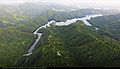
A view of Cerrillos State Forest around Lake Cerrillos.
-
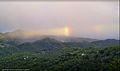
Cerrillos State Forest seen from a mountain to the west.
-
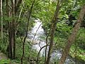
The Cerrillos River flowing through the forest.


