
Yuna River facts for kids
Quick facts for kids Yuna River |
|
|---|---|
 |
|

Map showing the Yuna drainage basin
|
|
| Other name(s) | Río Yuna |
| Country | |
| Provinces | Monseñor Nouel, Sánchez Ramírez, Duarte, Samaná |
| Cities | Bonao, Cotuí |
| Physical characteristics | |
| Main source | Cerro Montoso Hill La Cuesta de la Vaca, Bonao, Monseñor Nouel, Dominican Republic 1,075 m (3,527 ft) 18°47′16″N 70°25′05″W / 18.78778°N 70.41806°W |
| River mouth | Samaná Bay Los Haitises National Park, Sánchez, Samaná, Dominican Republic 0 m (0 ft) 19°11′47″N 69°37′24″W / 19.19639°N 69.62333°W |
| Length | 185.17 km (115.06 mi) |
| Basin features | |
| Basin size | 5,498 km2 (2,123 sq mi) |
| Tributaries |
|
The Yuna River (which is called Río Yuna in Spanish) is the second longest river in the Dominican Republic. It is about 185.17 km (115.06 mi) long. The river starts in the Cordillera Central mountains. This is southwest of the city of Bonao in Monseñor Nouel Province. The Yuna River then flows through the very rich Cibao Valley.
From there, the river turns towards the north-northeast. It passes by the city of Bonao. Southwest of Cotuí, the river reaches the Hatillo Dam (Presa de Hatillo). After the dam, it turns northeast and then east. Finally, it reaches its end at the Samaná Bay in the northeast of the Dominican Republic. Like many rivers in this country, the name Yuna comes from the old Taíno language.
Contents
Where the Yuna River Starts and Flows
The Yuna River begins on Cerro Montoso Hill. This hill is near the village of La Cuesta de la Vaca in Monseñor Nouel Province. The river starts high up, at about 1,075 m (3,527 ft) above sea level. Cerro Montoso Hill is part of the Cordillera Central. This is the highest mountain range in the West Indies.
The Cordillera Central is very important for the Dominican Republic's rivers. It acts like a giant natural divider for water. The Yuna River starts on the northern side of these mountains. As it flows, many smaller streams join it. The river first runs south, then west, near the border of San José de Ocoa Province.
The Yuna then turns north near the village of El Torito. It flows through mountains like Torito Hill and Middle Hill. After this, the river moves north-northwest. It passes through villages such as Pino de Yuna and El Capa.
The River's Journey Through Provinces
The Yuna River then flows into Los Finitos village. Here, it takes a more northerly path. Two rivers, the Blanco River and the Tireo River, join the Yuna from its left side. The Yuna then heads northeast. It moves into lower areas as it leaves the Cordillera Central mountains.
The river passes Los Quemados village. Here, more streams from the Cordillera Central join it. The Yuna then flows northwest of the city of Bonao. It enters the town of Los Arroces. A large river called the Masopedro River joins it here from the left. The Yuna then goes east, passing under the Autopista Duarte highway. It enters another hilly area of Monseñor Nouel.
The Yuna also passes north of Falconbridge Ltd.. This company is a big part of the economy for the Bonao area. The Yuna continues east, cutting through hills like Flat Hill. Here, the Yujo River flows into the Yuna. The river then follows the border of Sánchez Ramírez Province. It enters this province when it reaches Lake Hatillo (Presa de Hatillo) near Cotuí. Here, it meets the Maimón River.
Lake Hatillo and Its Importance
Lake Hatillo is a large artificial lake. It runs north-northeast for about 15.46 km (9.61 mi). The lake covers an area of about 27.94 km2 (10.79 sq mi). It is surrounded by rolling hills. This lake is the largest artificial lake in the Caribbean. It also has the biggest dam in the Caribbean.
The Hatillo Dam on the Yuna River helps control floods. This means it can hold back water during heavy rains. This helps protect towns and farms downstream.
Flowing Towards the Sea
After the dam, the Yuna River keeps flowing northeast. It gets lower in elevation. The Maguaca River and later the Chacuey River join it from the right side. The Yuna passes north of Cotuí city. It then enters an area of Sánchez Ramírez Province that has many cocoa farms.
The most important river that joins the Yuna is the Camú River. This happens about 11.60 km (7.21 mi) northeast of Cotuí. It joins at the border of Duarte Province. The Camú River also starts in the Cordillera Central mountains. It collects water from seven different provinces.
After the Camú River joins, the Yuna turns east. It becomes the border between Sánchez Ramírez and Duarte Provinces. It flows into wetlands where people grow rice and cocoa. The Yuna River has many curves in this eastern part. It continues to get lower in elevation. It reaches 24 m (79 ft) above sea level when it enters Duarte Province. Here, two smaller rivers, the Nigua and Yaiba Rivers, join it.
Reaching the Samaná Bay
The Yuna River then flows into the municipality of Villa Riva. It moves east-northeast and gets even lower, to about 20 m (66 ft) above sea level. The Yuna passes north of Los Haitises National Park. Here, the Cevicos River joins it from the right.
The Yuna then goes through an area with many lagoons and wetlands. It heads north to Villa Riva town. Then it turns southeast. The Payabo River joins it from the right. The Yuna passes under the Autopista Juan Pablo II highway. It briefly enters the municipality of Arenoso. It continues east, passing small villages like Los Coles.
The Yuna River then reaches Los Cacaos village. Here, it forms the border between Duarte and Samaná Province. This area has many marshlands. A branch of the Yuna, the Barracote River, separates from the main river. The Barracote River is about 15.07 km (9.36 mi) long. It flows southeast-east and reaches Samaná Bay in Sánchez.
The main Yuna River continues northeast. The Guayabo River joins it from the left. Then it flows east into Samaná Province. The Yuna finally forms its delta inside Los Haitises National Park. This is about 3.84 km (2.39 mi) south of Sánchez. The delta is in an area called the Lower Yuna Mangroves. It empties into the Samaná Bay. Samaná Bay is one of the largest estuaries in the Caribbean. An estuary is where a river meets the sea.
The Yuna River provides Samaná Bay with a steady flow of fresh water for most of the year. But twice a year, the Yuna River rises. During these times, it brings a lot more fresh water into the Bay. In total, the Yuna River is about 208 km long.
How the Yuna River Helps Farming
The Yuna River is very important for farming, especially for growing rice. Where the river flows near the city of Bonao, its water is used to irrigate rice fields. This means the river water helps the rice plants grow.
Geology of the Riverbed
Most of the Yuna River's bottom is covered with plants. However, south of Bonao, there is a lot of gravel. Gravel is small stones and pebbles.
Images for kids
-
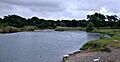
The Yuna River
See also
 In Spanish: Río Yuna para niños
