
Navassa Island facts for kids
Quick facts for kids Navassa Island |
|||
| Island | |||
 Aerial view of the east coast
|
|||
|
|||
| Country | United States | ||
|---|---|---|---|
| Parts | Lulu Town | ||
| Location | Caribbean Sea | ||
| Area | 5.2 km² (2 sq mi) | ||
| Population | Uninhabited. Hundreds of laborers lived here while it was being mined | ||
| Animal | Wildlife preserve | ||
| Material | Coral, limestone | ||
| Easiest access | Offshore anchorage only; steep cliffs make boat landing impossible | ||
| Discovered by | Christopher Columbus | ||
| - date | 1504 | ||
| FIPS | bq | ||
| Claimed by Haiti | |||
.svg)
Navassa Island, also called La Navase in Haitian Creole, is a small island in the Caribbean Sea. No one lives on it today. It is about 90 miles (145 km) south of Guantánamo Bay, Cuba.
The United States claims this small island as its territory. It is managed by the United States Fish and Wildlife Service, which protects its nature. The island is also claimed by Haiti.
Sailors with Christopher Columbus named the island Navassa in 1504. They couldn't find any fresh water there.
A captain named Peter Duncan claimed it for the U.S. in the late 1850s. This was for mining guano, which is bird droppings used as fertilizer. After a rebellion in 1889 and the Spanish–American War of 1898, the mining stopped.
When the Panama Canal opened in 1914, Navassa became important again. A lighthouse was built there to help ships navigate. After World War II, no one lived on the island again.
In 1996, the lighthouse was turned off. The island was then given to the United States Department of the Interior. Three years later, in 1999, the United States Fish and Wildlife Service took over managing the island.
Island History
Navassa became a U.S. territory in October 1857. A company representative took control of the island for the United States. This was done to mine guano, which was valuable at the time.
By 1889, the Navassa Phosphate Company was running the mining operations. However, all mining stopped in 1898. The island was left empty after that.
Island Geography
Navassa Island is about 2 square miles (5.2 square kilometers) in size. It lies about 100 miles (160 km) south of Guantanamo Bay, Cuba. It is also about 30 miles (48 km) west of Cape Tiburon, Haiti.
The island has a tropical marine climate, meaning it's warm and humid.
Navassa's land is a raised plateau made of coral and limestone. It is mostly flat but has some gentle hills. The island is surrounded by tall, white cliffs that are about 9 to 15 yards (8 to 14 meters) high.
Most of the island is exposed rock. However, it has enough grassland to support wild goats. There are also thick groups of fig-like trees and scattered cactus plants. Only about one-tenth of the island's land is meadows or pastures. Navassa has no ports, so boats can only anchor offshore.

In 1976, the U.S. Coast Guard decided that the lighthouse on Navassa was no longer needed. They stopped managing the island. However, this did not change the fact that the United States still owned the island.
Because of this, the United States Department of the Interior became responsible for managing Navassa. They looked into the island's environment. They decided not to allow visitors to the island or its surrounding waters for a long time. This was to protect the island's nature. The "surrounding waters" include the ocean up to 12 nautical miles (22 km) from the coast.
On September 2, 1999, the United States Fish and Wildlife Service created the Navassa Island Wildlife Refuge. This means the island is now a protected area for wildlife. Since December 3, 1999, the Fish and Wildlife Service has been fully in charge of Navassa Island.
Images for kids
-
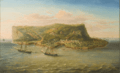
An unsigned painting of Navassa Island c. 1870 showing the brig Romance, company buildings at Lulu Town near the shore, and guano mining activity up the hillside.
-
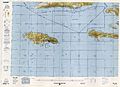
Map including Navassa Island (NIMA, 1996)
-
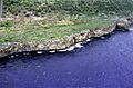
Navassa Island has a steep and rocky coastline that rings the island.
-
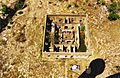
The ruins of Navassa Light keeper's quarters


See also
 In Spanish: Isla de Navaza para niños
