
Cap-Haïtien facts for kids
Quick facts for kids
Cap-Haïtien
Kap Ayisyen
|
|
|---|---|
|
Commune
|
|

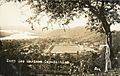
Skyline of Cap-Haïtien
|
|
| Nicknames:
Le Paris des Antilles
The Paris of the Antilles |
|

Cap-Haïtien
Location in Haiti
|
|
| Country | Haiti |
| Department | Nord |
| Arrondissement | Cap-Haïtien |
| Founded | 1670 |
| Area | |
| • Total | 53.5 km2 (20.7 sq mi) |
| Elevation | 0 m (0 ft) |
| Population
(March, 2015)
|
|
| • Total | 274,404 |
| • Density | 5,129/km2 (13,280/sq mi) |
| Demonym(s) | Capois(e) |
| Time zone | UTC-5 (Eastern) |
| • Summer (DST) | UTC-4 (Eastern) |
| Website | https://visithaiti.com/destinations/cap-haitien-city-guide/ |
Cap-Haïtien (pronounced Kap Ayisyen), often called Le Cap or Okap, is a lively city on the north coast of Haiti. It's home to about 274,000 people and is the capital of the Nord department. In the past, it was known as Cap-Français and Cap-Henri. People used to call it the Paris of the Antilles because it was a rich and fancy city with beautiful buildings and a strong art scene.
Cap-Haïtien was a very important city during the time of French rule. It was the capital of the French colony of Saint-Domingue from its founding in 1711 until 1770. After Haiti won its freedom, it became the capital of the Kingdom of Haiti under King Henri I until 1820.
The city's location, far from the capital Port-au-Prince and separated by mountains, helped its people think independently. This led to many movements for freedom, even during the time of slavery. For example, in 2004, people in the city protested against the president, which led to him leaving office.
Cap-Haïtien is close to the historic town of Milot, about 12 kilometers (7.5 miles) away. Milot was Haiti's first capital under King Henri Christophe. His famous Sans-Souci Palace was there, but it was damaged by an earthquake in 1842. The huge Citadelle Laferrière, a strong stone fortress with many cannons, is also nearby, about 5 kilometers (3 miles) away. On clear days, you can see its shape from Cap-Haïtien.
The small Cap-Haïtien International Airport is on the city's edge. It's an important airport, especially after the main airport in Port-au-Prince faced issues in 2024. Many people moved to Cap-Haïtien from the capital during a recent crisis, which put a strain on the city's services.
Contents
History of Cap-Haïtien

For thousands of years, the island was home to indigenous peoples who came from Central and South America. In the 1500s, Spanish explorers arrived and began to settle the island, which they called Hispaniola. They used the native name Guárico for the area that is now Cap-Haïtien. Sadly, many indigenous people died because of new diseases and harsh treatment.
Near Cap-Haïtien, Christopher Columbus started his first community in the New World, called La Navidad, but it didn't last long. In 1975, researchers found the ruins of another early Spanish town, Puerto Real, which was founded in 1503 and abandoned in 1578.

In the early 1700s, the French took control of about a third of Hispaniola from the Spanish. They built large sugar cane farms and brought thousands of enslaved Africans to work on them. Cap-Français became a major port and business center for the French colony of Saint-Domingue. It was the capital from 1711 until 1770, when the capital moved to Port-au-Prince. After the Haitian Revolution, when the country was divided, Cap-Français became the first capital of the Kingdom of Haiti under King Henri I.
The main part of Cap-Haïtien is located between the Bay of Cap-Haïtien and the nearby mountains. The streets are usually narrow and set up in a grid pattern. During the time the United States occupied Haiti (1915-1934), the north-south streets in Cap-Haïtien were renamed with single letters (like Rue A), and the east-west streets were given numbers. Many old buildings in the city have balconies on their upper floors, creating a friendly atmosphere.
Economy and Architecture

Cap-Haïtien is famous for its many historic buildings and is a popular place for tourists. Its beautiful bay, beaches, and historical sites make it a favorite vacation spot, especially for people from Haiti's upper classes. It has also attracted international tourists because it has often been more stable than the southern part of the island.
The city has many well-preserved French colonial buildings. After the Haitian Revolution, many skilled builders from Cap-Haïtien, who were free people of color, moved to New Orleans. Because of this, the two cities share similar building styles, including the unique "gingerbread houses" found on Cap-Haïtien's older streets.
Since 2021, Cap-Haïtien has had problems with electricity, mostly due to a lack of fuel. Some people who can afford it have started using solar power.
Tourism and Historic Sites
Labadie Beach Resort

The private beach resort of Labadee is about 6 kilometers (3.7 miles) northwest of Cap-Haïtien. It's a popular stop for Royal Caribbean International cruise ships. These large ships dock weekly at Labadie. The resort is leased by Royal Caribbean and has brought a lot of tourist money to Haiti since 1986. It provides jobs for many local people and allows others to sell their crafts there.
Labadie is connected to Cap-Haïtien by a paved road. Royal Caribbean built a pier there in 2009, so even the biggest cruise ships can dock easily. Visitors can enjoy a Haitian market, many beaches, water sports, a water playground, and a zip-line.


Other beaches like Cormier Plage are also nearby. You can take water taxis from Labadie to other beautiful spots like Paradis beach. Belli Beach is another small sandy area with boats and hotels.
Vertières: A Battle for Freedom
Vertières is the place where the Battle of Vertières happened. This was the last and most important battle of the Haitian Revolution. On November 18, 1803, the Haitian army, led by Jean-Jacques Dessalines, defeated the French army. The French left Haiti, and in 1804, Haiti declared its independence.
In this battle, a brave leader named Capois La Mort kept moving forward even when French bullets hit his horse and hat. He yelled, "En avant!" (Go forward!) to his soldiers. He became a hero of the revolution. November 18 is now celebrated as a Day of Army and Victory in Haiti.
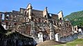
Citadelle Henry and Sans-Souci Palace


The Citadelle Laferrière, also called Citadelle Henry, is a huge fortress built on a mountaintop. It's about 17 kilometers (10.5 miles) south of Cap-Haïtien, near Milot. It's the largest fortress in the Americas! In 1982, UNESCO recognized it as a World Heritage Site, along with the nearby Sans-Souci Palace.
The Citadel was built by Henry Christophe, who was a leader during the Haitian slave rebellion and later became King of Northern Haiti. He built it after Haiti gained independence from France in 1804. The Sans-Souci Palace was damaged in an earthquake in 1842, but its ruins are still an important historical site.
Bois Caïman: A Secret Meeting Place
Bois Caïman (pronounced Bwa Kayiman), about 3 kilometers (1.8 miles) south of the main road, is a very important historical spot. It's where a special ceremony took place under a tree at the start of the slave revolution. For many years, runaway slaves, called maroons, had been fighting against slaveholders.
At Bois Caïman, a maroon leader named Dutty Boukman held a secret meeting on August 14, 1791. During this meeting, a Vodou ceremony was performed, and everyone present promised to fight for freedom, even if it meant dying. After this powerful ritual, the rebellion began on the night of August 22–23, 1791. The enslaved people burned plantations and sugar cane fields and attacked French colonists. This uprising eventually led to Haiti's independence from France and freedom for all enslaved people. The spot where Dutty Boukman's ceremony happened is marked by a ficus tree.
Morne Rouge
Morne Rouge is about 8 kilometers (5 miles) south of Cap-Haïtien. It was once a sugar plantation called "Habitation Le Normand de Mezy," known for several enslaved people who led the fight against the French.
Disasters and Resilience
1842 Cap-Haïtien Earthquake
On May 7, 1842, a powerful earthquake destroyed most of Cap-Haïtien and other towns in northern Haiti. About ten thousand people lost their lives. The earthquake was very strong, estimated at magnitude 8.1. The Sans-Souci Palace was also badly damaged.
2010 Haiti Earthquake
When a major earthquake hit Haiti in 2010, it badly damaged the port in Port-au-Prince. Because Cap-Haïtien's port was not as damaged, it was used to bring in important relief supplies by ship. Many business people and residents moved to Cap-Haïtien from Port-au-Prince after the earthquake.
Cap-Haïtien Fuel Tanker Explosion
On December 14, 2021, a fuel tank truck overturned and exploded in Cap-Haïtien. Sadly, over 75 people were killed in this accident.
Getting Around Cap-Haïtien
Airports
Cap-Haïtien is served by the Cap-Haïtien International Airport (CAP), which is Haiti's second busiest airport. It connects the city to other parts of Haiti and sometimes to other countries.
Seaport
The Port international du Cap-Haïtien is the city's main seaport. It's an important place for trade and shipping.
Roads
Two main roads, Route Nationale#1 and Route Nationale#3, connect Cap-Haïtien to the capital city, Port-au-Prince. Cap-Haïtien has a well-organized street system, with north-south streets named with letters (like Rue A) and east-west streets named with numbers. The Boulevard du Cap-Haitian runs along the Atlantic Ocean.
Public Transportation
In Cap-Haïtien, people get around using tap taps (colorful shared taxis), local taxis, or motorcycles.
Education in Cap-Haïtien
Cap-Haïtien has several good schools, including four Catholic Church private schools that have been around for two decades. These schools are known for their high academic standards. The Lycée Philippe Guerrier, built in 1844, has also been an important center of learning for over a century.
- Collège Notre-Dame du Perpetuel Secours des Pères de Sainte-Croix
- Collège Regina Assumpta des Sœurs de Sainte-Croix
- École des Frères de l'instruction Chrétienne
- École Saint Joseph de Cluny des Sœurs Anne-Marie Javoue
- Lyceé Philippe Guerrier
Universities
The city is home to the Cap-Haitien Faculty of Law, Economics and Management, and the Public University of the North in Cap Haitien (UPNCH). The new Université Roi Henry Christophe is also nearby in Limonade.
Sports
Cap-Haïtien has the Parc Saint-Victor, which is home to three major league football (soccer) teams: Football Inter Club Association, AS Capoise, and Real du Cap.
Notable People from Cap-Haïtien
Many important people were born in Cap-Haïtien, including:
- Pierre Nord Alexis (1820 – 1910), a former President of Haiti.
- Tancrède Auguste (1856 – 1913), another former President of Haiti.
- Étienne Chavannes (born 1939), a Haitian painter.
- Tyrone Edmond, a Haitian-born model.
- Arly Larivière, a Haitian musician and composer.
- Yolette Lévy (1938–2018), a Haitian-born Canadian politician.
- Alfred Auguste Nemours (1883–1955), a military historian and diplomat.
- Philomé Obin (1892–1986), a famous artist and painter.
- Leonel Saint-Preux (born 1985), a footballer who played for the Haiti national team.
- Bruny Surin (born 1967), an Olympic medalist in track and field.
Images for kids
-
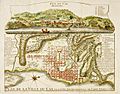
Engraving of Cap-Français in 1728
-
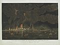
Fire of Cap Français, 21 June 1793
-
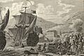
The French army led by Le Clerc lands in Cap Français (1802)
-
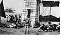
American Marines in 1915 defending the entrance gate in Cap-Haïten
-
Marine's base at Cap-Haïtien
-
Front view of Sans-Souci Palace
-
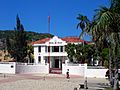
Hotel de Ville (City Hall), site of the City Council, Cap-Haïtien.
-
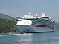
A cruise ship at Labadie.


_-_d%C3%A9tail.jpg)


See also
 In Spanish: Cabo Haitiano para niños
