
Chiefdoms of Hispaniola facts for kids
Quick facts for kids
Chiefdoms of Hispaniola
|
|||||||||
|---|---|---|---|---|---|---|---|---|---|
 |
|||||||||
| Cacique | |||||||||
|
|||||||||
| Today part of | Dominican Republic Haiti |
||||||||
The chiefdoms of Hispaniola were important political areas used by the Taíno people. They lived on the island of Hispaniola (which they called Ayiti, Quisqueya, or Bohio). When Europeans first arrived in 1492, the island was split into five main chiefdoms.
Each chiefdom was led by a powerful leader called a cacique. Below the cacique were smaller caciques who looked after villages or districts. There were also nitaínos, who were part of the Taíno elite, like a noble class.
The Taíno people of Hispaniola were related to other Arawak groups living on nearby islands. At the time Europeans arrived, the Taíno were sometimes at war with another group called the Island Caribs. Sadly, after Europeans arrived, the Taíno population quickly decreased. This was due to new diseases and harsh conditions.
The borders of each chiefdom were very clear. The Taíno used natural features like big rivers, tall mountains, and wide valleys to mark their territories. Each chiefdom was also divided into smaller areas called nitaínos. These smaller areas were led by the cacique's helpers. Below, you can see how these old chiefdoms connect to today's areas in Haiti and the Dominican Republic.
Contents
Marién Chiefdom: Land of the First Welcome

The Marién chiefdom covered the whole northwestern part of Hispaniola. The Atlantic Ocean was to its north. To the south was the Jaragua chiefdom. To the east were the Maguá and Maguana chiefdoms. The Windward Passage was to its west.
This chiefdom was ruled by the cacique Guacanagaríx. Its main city was El Guarico, close to where Cap-Haïtien is today. Marién was divided into 14 smaller areas called nitaínos. This chiefdom was the first to welcome Christopher Columbus and his crew.
The Marién chiefdom also fought against the Mairena chiefdom. The Mairena chiefdom was helped by Caonabo from the Maguana chiefdom. They fought over a mythical goddess called Iermao. Iermao was the "Mother" goddess of Marién, and her name means "body stone."
Where Was Marién?
Dominican Republic
Haiti
Maguá Chiefdom: The Rich Stone Land

The Maguá chiefdom was in the northeastern part of Hispaniola. The Atlantic Ocean was to its north and east. To the south were the Maguana and Higüey chiefdoms. To the west were the Marién and Maguana chiefdoms. All of Maguá's land is now in the Dominican Republic.
This chiefdom was ruled by the cacique Guarionex. Its center was near where Santo Cerro in La Vega is today. Maguá was divided into 21 nitaínos. It was known as one of the richest chiefdoms on the island.
Another group of people, called the Ciguayos, also lived in this area. They were mostly on the Samaná Peninsula and spoke the Ciguayo language. Over time, they became part of the Maguá chiefdom. A historian named Bartolomé de las Casas noted that their language was disappearing by 1502 and was gone by 1527.
The word Maguá means "the Stone." The chiefdom's main goddess was Guacara, or the 'Stone Mother'.
Where Was Maguá?
Dominican Republic
- Duarte
- Espaillat
- La Vega
- María Trinidad Sánchez
- Monseñor Nouel
- Puerto Plata
- Hermanas Mirabal
- Samaná
- Sánchez Ramírez
- Santiago
Maguana Chiefdom: The Strong First Stone

The Maguana chiefdom was in the center of the island. To the north were the Marién and Maguá chiefdoms. The Caribbean Sea was to its south. To the east were the Maguá and Higüey chiefdoms. To the west were the Marién and Jaragua chiefdoms. All of Maguana's land is now in the Dominican Republic.
This chiefdom was ruled by the cacique Caonabo. He was married to Anacaona. Its main place was Corral de los Indios, near today's Juan de Herrera in San Juan province. It was divided into 21 nitaínos.
Maguana was considered the most important chiefdom on the island. It was known as "The Rock." The name Maguana means "the first stone" or "the only stone." The chiefdom's main goddess was Apito, which means "Mother of Stone."
Cacique Caonabo was the first to fight against the Spanish. He destroyed La Navidad, a fort that Christopher Columbus had built. Caonabo also tried to attack Fortaleza de Santo Tomás. But he was captured by Spanish soldiers led by Alonso de Ojeda. Caonabo was sent to Spain to be shown to the Royal Court, but he died during the trip.
Where Was Maguana?
Dominican Republic
Jaragua Chiefdom: The Largest Territory

The Jaragua chiefdom covered the entire southwest of Hispaniola. To the north was the Marién chiefdom. The Caribbean Sea was to its south. To the east was the Maguana chiefdom. The Strait of Jamaica was to its west.
It was ruled by the cacique Bohechio (Beehechio) and was the biggest chiefdom. Its main area was in a place called Guava, which is now Léogâne in Haiti. Jaragua was divided into 26 nitaínos.
Bohechío was the brother of Anacaona, who was married to Caonabo, the cacique of Maguana. Because of this, Jaragua and Maguana had a strong friendship. They would work together to defend against and attack other chiefdoms.
The main goddess of the Jaragua chiefdom was Zuimaco.
Where Was Jaragua?
Dominican Republic
Haiti
Higüey Chiefdom: The Eastern Border

The Higüey chiefdom covered the entire southeast of Hispaniola. To the north were the Maguá chiefdom and the Bay Samana. The Caribbean Sea was to its south. To the east was the Canal de la Mona. To the west was the Maguana chiefdom.
It was ruled by the cacique Cayacoa and was divided into 21 nitaínos. The capital of this chiefdom was located in today's Higüey.
Some records state that Cotubanama was the cacique of Higüey. He was captured by Juan de Esquivel and later executed in Santo Domingo.
The main goddess of Higüey was Atabeira, which means "Mother of the original stone."
Where Was Higüey?
Dominican Republic
- Distrito Nacional
- El Seibo
- Hato Mayor
- La Altagracia
- La Romana
- Monte Plata
- San Pedro de Macorís
- Santo Domingo
Images for kids
-
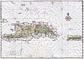
Old Map of Hispañola
-
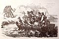
Christopher Columbus travelling to Higuey.

.jpg)
See also
 In Spanish: Taínos de La Española para niños
