
El Seibo Province facts for kids
El Seibo is a province located in the eastern part of the Dominican Republic. Its main city and capital is Santa Cruz del Seibo. This province is one of the oldest in the country. When the Dominican Republic became independent in 1844, El Seibo was one of the five original provinces mentioned in the first Dominican constitution. Its name has always been El Seibo, though sometimes it was spelled El Seybo.
Contents
What's in a Name?
The El Seibo province gets its name from its most important city, El Seibo.
Where is El Seibo Located?
The El Seibo province is surrounded by other provinces and the ocean. To its east is the La Altagracia province. To the south, you'll find the San Pedro de Macorís province. To the west, it borders the Hato Mayor province. Looking north from El Seibo, you'll see the Samaná Bay, which is part of the huge Atlantic Ocean.
 |
Samaná Bay | Atlantic Ocean | |
|
| Hato Mayor province | La Altagracia province | |||
| San Pedro de Macorís province |
A Look Back at El Seibo's History
After the Dominican Republic gained its independence on July 24, 1844, the new government created five main areas called "departments." One of these was the El Seibo Department. It included the areas of El Seibo, Hato Mayor, Higüey, and Samaná. The first Dominican constitution later changed these departments into what we now call provinces.
At first, the El Seibo province covered a very large area, including the entire eastern part of the island of Hispaniola and the Samaná peninsula. However, over time, parts of El Seibo were used to create new provinces. The first two provinces to be formed from El Seibo's land were Samaná in 1865 and San Pedro de Macorís in 1882.
Later, in 1961, the old La Altagracia province was created from El Seibo. This province was later divided into the current La Altagracia and La Romana provinces. The most recent province to be formed from a part of El Seibo was Hato Mayor in 1984.
People from El Seibo played a big role in the war for independence against Haiti. Their leader was Pedro Santana, who owned a farm near the city of El Seibo. He later became the first president of the Dominican Republic.
Even before the independence war, people from El Seibo fought against the French army. A very important battle called the Palo Hincado Battle took place on November 7, 1808. Dominicans won this battle in a savanna (a grassy plain) called Palo Hincado Savanna, just east of Santa Cruz del Seibo. Soon after, the French had to leave the entire island, as they had also lost control of Haiti.
The province is divided into smaller areas called municipal districts. These districts were created over time:
- 1997: Pedro Sánchez
- 2001: El Cedro
- 2005: La Gina
- 2006: San Francisco-Vicentillo and Santa Lucía
How Many People Live in El Seibo?
In 2014, which was the last national census, there were about 110,212 people living in the El Seibo province. Out of these, 45,103 people lived in towns and cities. The population density was about 61.6 people per square kilometer. This is one of the lowest population densities in the country.
The population of El Seibo province makes up about 1.17% of the total population of the Dominican Republic. Among all the provinces, El Seibo is ranked as the 25th most populated.
As of As of 2016[update], it is estimated that the total population of the province is around 91,256 people.
The largest city in the province is Santa Cruz del Seibo. This city is the capital and had an urban population of 26,477 people in 2010.
The Geography of El Seibo
El Seibo province covers a total area of about 1,788.4 km2 (690.5 sq mi). This means it takes up about 3.7% of the total area of the Dominican Republic. It is ranked as the 11th largest province in the country.
The province has at least three different geographic areas, moving from north to south:
- Coastal plains: These are small flat areas found along the Atlantic coast.
- Cordillera Oriental: This is a mountain range in the east, with mountains that are not very high.
- Llano Costero del Caribe: This means "Caribbean Coastal Plain" in English. It's a large prairie with important savannas (grassy plains).
The Soco River is the most important river in the province. It starts in the Cordillera Oriental mountains and flows down to the Caribbean Sea.
The main road in the province is called the Carretera Mella (Mella National Road). This road runs through the middle of the province. It comes from Santo Domingo and passes through the cities of Hato Mayor and Santa Cruz del Seibo, ending in Higüey.
Cities and Districts
El Seibo province has 2 main municipalities and 5 municipal districts (M.D.). Here are the municipalities and their municipal districts:
| Municipality (code) | Municipal Districts (code) | Population (2010) |
Area (km2) |
Density | Altitude (m) |
|---|---|---|---|---|---|
| Santa Cruz del Seibo (080101) | 46,285 | 886.3 | 52.2 | 110 | |
| Pedro Sánchez (080102) | 4,245 | 117.1 | 36.3 | 156 | |
| San Francisco-Vicentillo (080103) | 4,524 | 200.3 | 22.6 | 198 | |
| Santa Lucía (080104) | 11,742 | 141.0 | 83.3 | 194 | |
| Santa Cruz del Seibo (080100) | 66,867 | 1,344.6 | 49.7 | ||
| Miches (080201) | 10,152 | 93.6 | 108.5 | 16 | |
| El Cedro (080202) | 7,539 | 285.8 | 26.4 | 15 | |
| La Gina (080203) | 3,122 | 64.4 | 48.5 | 73 | |
| Miches (080200) | 20,813 | 443.8 | 46.9 | ||
| El Seibo province (080000) | 87,680 | 1,788.4 | 49.0 | ||
What is the Economy Like in El Seibo?
The most important economic activity in El Seibo province is Cattle raising. This means farming animals like cows. The main crops grown here are sugar cane and cacao.
Related pages
Images for kids
-
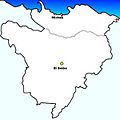
Municipalities of El Seibo Province, Dominican Republic.
-
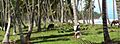
Miches, El Seibo, Dominican Republic beach.

See also
 In Spanish: Provincia de El Seibo para niños
