
La Altagracia Province facts for kids
Quick facts for kids La Altagracia |
||
| Province | ||
 |
||
|
||
| Country | ||
|---|---|---|
| Development region | Yuma (VIII) | |
| Capital | Higüey | |
| - elevation | 106 m (348 ft) | |
| - coordinates | 18°37′12″N 68°42′36″W / 18.62000°N 68.71000°W | |
| Area | 2,998.4 km² (1,158 sq mi) | |
| Population | 372,289 (2014) | |
| Density | 124 /km² (321 /sq mi) | |
| Province since | 1961 | |
| Subdivisions | 2 municipalities 5 municipal districts |
|
| Congresspersons | 1 Senator 4 Deputies |
|
| Timezone | EST (UTC-4) | |
| Area code | 1-809 1-829 1-849 | |
| ISO 3166-2 | DO-11 | |

La Altagracia is a beautiful province located in the easternmost part of the Dominican Republic. It was created in 1961. Its main city and capital is Higüey. This province is famous for its stunning beaches and important historical sites.
Contents
Where is La Altagracia?
La Altagracia province has a special location. To its north and east, you'll find the vast Atlantic Ocean. To the south, it borders the warm Caribbean Sea. The Mona Passage, a narrow strait connecting these two oceans, is to the southeast. On its western side, La Altagracia shares borders with the La Romana and El Seibo provinces.
 |
Atlantic Ocean | |
||
| El Seibo province | Atlantic Ocean | |||
| La Romana province | Caribbean Sea | Mona Passage |
A Look at History
Before 1961, the area that is now La Altagracia was part of other provinces. First, it was part of El Seibo. Then, in 1944, it became part of the new La Romana.
On February 27, 1961, La Romana province was divided into two separate provinces. This is how La Altagracia province was officially created. It started with two main areas called municipalities: Higüey and San Rafael del Yuma. The city of Salvaleón de Higüey became the capital. Over the years, more smaller areas, called municipal districts, were added. These include Las Lagunas de Nisibón (1982), La Otra Banda (1987), Boca del Yuma (2001), Bayahibe (2002), and Verón Punta-Cana (2006).
Why the Name La Altagracia?
The province gets its name, La Altagracia, which means "High Grace," from a very important place. This is the Basílica de Nuestra Señora de la Altagracia (Our Lady of High Grace Basilica). This famous church is located in the capital city of Higüey.
People of La Altagracia
According to the last national census in 2014, about 372,289 people lived in La Altagracia province. A large number of these people, 222,802, lived in towns and cities. This means the province has a population density of about 124.2 people per square kilometer.
La Altagracia holds the 9th spot among the 31 provinces (plus the National District) in terms of population. Its population makes up about 3.94% of the Dominican Republic's total population.
As of As of 2016[update], it's estimated that the province has grown to about 322,653 residents. The biggest city in the province is Higüey. In 2014, Higüey had a population of 168,501 people.
Geography and Nature
La Altagracia province covers a total area of 2,998.4 km2 (1,157.7 sq mi). This makes it the second largest province in the Dominican Republic. It covers about 6.2% of the country's total land area.
The capital city, Salvaleón de Higüey, is located at an altitude of about 87 m (285 ft) above sea level. One of the most important natural areas in the province is the Parque Nacional del Este (Eastern National park). This park helps protect the local wildlife and plants.
Mountains and Landscapes
In the northern part of the province, you can find some low mountains. These mountains are part of a larger chain called the Cordillera Oriental (Eastern mountain range). Throughout the province, you will also see many Savannas, which are wide, flat grasslands.
Rivers in the Province
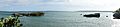
La Altagracia does not have many large rivers. The most important river is the Yuma River. It flows from the north down to the south, eventually emptying into the Caribbean Sea.
Climate of La Altagracia
The province experiences a tropical climate. This means it is generally hot for most of the year.
Municipalities and Districts
La Altagracia province is divided into 2 main municipalities and 5 smaller areas called municipal districts (M.D.). Here's a look at them:
| Municipality (code) |
Municipal Districts (code) | Population (2010) |
Area (km2) |
Density | Altitude (m) |
|---|---|---|---|---|---|
| Higüey (110101) | 168,501 | 907.7 | 185.6 | 87 | |
| Las Lagunas de Nisibón (110102) | 9,831 | 315.2 | 31.2 | 41 | |
| La Otra Banda (110103) | 28,929 | 318.9 | 90.7 | 108 | |
| Verón Punta Cana (110104) | 43,982 | 475.3 | 92.5 | 17 | |
| Higüey (110100) | 251,243 | 2,017.3 | 124.5 | ||
| San Rafael del Yuma (110201) | 17,886 | 530.8 | 33.7 | 55 | |
| Boca de Yuma (110202) | 1,821 | 232.0 | 7.8 | 16 | |
| Bayahibe (110203) | 2,260 | 218.4 | 10.3 | 9 | |
| San Rafael del Yuma (110200)) | 21,967 | 981.2 | 22.4 | ||
| La Altagracia province (110000) | 273,210 | 2,998.4 | 91.1 | ||
Economy and Tourism
The economy of La Altagracia province relies on two main activities: farming and tourism. In farming, people raise cattle and grow sugar cane.
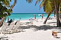
However, tourism is the biggest part of the economy. The eastern coast of the province, especially the areas of Punta Cana and Bávaro, is a huge tourist hotspot. Many hotels are built along the beautiful beaches with their soft, white sand. Bayahibe, on the southern coast, is also a popular place for tourists to visit.
Related Pages
Images for kids
-
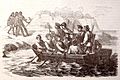
Christopher Columbus travelling to Higuey.
-
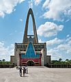
Cathedral of Higuey.
-
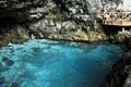
Hoyo Azul in Punta Cana, Dominican Republic.
-
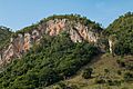
Hills in Higuey, Dominican Republic.
-

Zipline in Bavaro Park.
-
Boca de Yuma (Mouth of the Yuma) river.
-
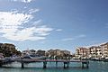
Punta Cana Marina.
-
Saona Island in the Province of La Altagracia.
.jpg)


See also
 In Spanish: Provincia de La Altagracia para niños
