La Romana Province facts for kids
Quick facts for kids La Romana |
||
| Province | ||
|
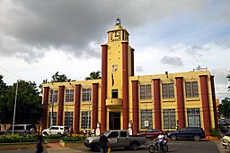
La Romana town hall
|
||
|
||
| Country | ||
|---|---|---|
| Development region | Yuma (VIII) | |
| Capital | La Romana | |
| - elevation | 10 m (33 ft) | |
| - coordinates | 18°25′48″N 68°58′12″W / 18.43000°N 68.97000°W | |
| Lowest point | Caribbean Sea | |
| - location | 0 | |
| Area | 652.1 km² (252 sq mi) | |
| Population | 344,580 (2014) | |
| Density | 528 /km² (1,368 /sq mi) | |
| Province since | 1944 | |
| Subdivisions | 3 municipalities 2 municipal districts |
|
| Congresspersons | 1 Senator 4 Deputies |
|
| Timezone | EST (UTC-4) | |
| Area code | 1-809 1-829 1-849 | |
| ISO 3166-2 | DO-12 | |
La Romana is a province in the southeastern part of the Dominican Republic. Its capital city is also called La Romana. This area became a province in 1959. Before that, it was a smaller part of the El Seibo province.
Contents
Where is La Romana Province?
La Romana province is located in the southeast of the Dominican Republic. It shares borders with other provinces:
- To the northwest, it borders the El Seibo province.
- To the northeast and east, it borders the La Altagracia province.
- To the west, it borders the San Pedro de Macorís province.
- To the south, it meets the beautiful Caribbean Sea.
 |
El Seibo province.! | La Altagracia province |  |
|
| San Pedro de Macorís province | La Altagracia province | |||
| Caribbean Sea |
History of La Romana Province
The province was first created in 1944 and named La Romana. At that time, it included two main areas: La Romana (the capital) and Higüey. Before 1944, this region was part of the El Seibo province.
Later in 1944, the province's name was changed to La Altagracia. However, in 1961, its original name, La Romana, was given back when a new La Altagracia province was formed.
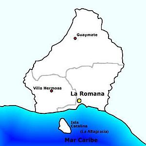
Over the years, more areas were added to La Romana province. Guaymate became a municipality in 1971. Villa Hermosa joined as a municipality in 2004. Two smaller areas, Cumayasa and Caleta, became municipal districts in 2004 and 2006, respectively.
Population and People
In 2014, the last time a national count was done, there were about 344,580 people living in La Romana province. A large number of these people, 231,312, live in towns and cities. This makes La Romana one of the few provinces where most people live in urban areas.
The province has a high population density, meaning many people live in a small space. It is one of the most populated provinces in the country, ranking 10th out of 31 provinces.
As of As of 2016[update], the total estimated population for the province is around 262,551 people.
The largest city in the province is La Romana, which is the capital. In 2014, it had a population of 130,426 people.
Most of the people in La Romana province are of African descent.
Geography and Natural Features
La Romana province covers an area of about 652.1 km2 (251.8 sq mi). It is one of the smallest provinces in the Dominican Republic, ranking 30th in size.
The capital city, La Romana, is about 36 m (118 ft) above sea level.
The land in La Romana province is mostly flat, with only a few low hills. Important rivers in the province include:
- The Chavón River, which forms part of the province's eastern border.
- The Dulce or La Romana River, which flows through the capital city.
- The Cumayasa River, located on the province's western border.
Two small but beautiful islands, Saona and Catalina, are also part of La Romana province.
A significant natural area here is the Parque Nacional del Este, also known as the "Eastern National park". It's a protected area with diverse wildlife.
Climate
The climate in La Romana province is tropical. This means it is hot for most of the year.
Local Government: Municipalities
La Romana province is divided into 3 main areas called municipalities and 2 smaller areas called municipal districts (M.D.). These are like local towns and their surrounding areas.
| Municipality (code) |
Municipal Districts (code) | Population (2010) |
Area (km2) |
Density | Altitude (m) |
|---|---|---|---|---|---|
| La Romana (120101) | 130,426 | 267.8 | 487.0 | 36 | |
| Caleta (120102) | 9,245 | 4.5 | 2,054.4 | 3 | |
| La Romana (120100) | 139,671 | 272.2 | 513.1 | ||
| Guaymate (120201) | 16,558 | 262.3 | 63.1 | 88 | |
| Guaymate (120200)) | 16,558 | 262.3 | 63.1 | ||
| Villa Hermosa (120301) | 77,241 | 19.9 | 3,881.5 | 74 | |
| Cumayasa (120302) | 11,963 | 97.7 | 122.4 | 41 | |
| Villa Hermosa (120300) | 89,204 | 117.6 | 758.5 | ||
| La Romana province (120000) | 245,433 | 652.1 | 376.4 | ||
Economy and Industries
La Romana province has a strong economy with several important industries. One of the oldest and most significant is the production of sugar.
Another key part of the economy is the zona franca, or "free zone". In this special area, industries do not have to pay certain taxes, and most of the products they make are sent to other countries.
Tourism is also very important for the province. Many people visit the capital city and enjoy the beautiful beaches on Saona and Catalina islands.
Related pages
See also
 In Spanish: Provincia de La Romana para niños
 | John T. Biggers |
 | Thomas Blackshear |
 | Mark Bradford |
 | Beverly Buchanan |


