
Hato Mayor Province facts for kids
Quick facts for kids Hato Mayor |
||
| Province | ||
|
||
| Country | ||
|---|---|---|
| Development region | Higuamo (IX) | |
| Capital | Hato Mayor del Rey | |
| - elevation | 106 m (348 ft) | |
| - coordinates | 18°46′12″N 69°15′36″W / 18.77000°N 69.26000°W | |
| Lowest point | Atlantic Ocean | |
| - elevation | 0 m (0 ft) | |
| Area | 1,319.3 km² (509 sq mi) | |
| Population | 103,032 (2014) | |
| Density | 78 /km² (202 /sq mi) | |
| Province since | 1984 | |
| Subdivisions | 3 municipalities 4 municipal districts |
|
| Congresspersons | 1 Senator 2 Deputies |
|
| Timezone | EST (UTC-4) | |
| Area code | 1-809 1-829 1-849 | |
| ISO 3166-2 | DO-30 | |

Hato Mayor is a Dominican province. It is located in the eastern part of the country. Its name comes from its capital city, Hato Mayor del Rey. In English, this name means 'the King's largest cattle farm'.
Hato Mayor is one of the newer provinces in the Dominican Republic. It officially became a province on December 3, 1984. Before this, its land was part of the El Seibo province.
Contents
Where is Hato Mayor Located?
Hato Mayor province is surrounded by other provinces. To the northwest, it borders Samaná. To the east, you'll find the El Seibo province. On its western side is the Monte Plata province. To the south, it borders the San Pedro de Macorís province. The Samaná Bay is located to the north of the province.
 |
Samaná | Samaná Bay | |
|
| Monte Plata | El Seibo | |||
| San Pedro de Macorís |
A Look at Hato Mayor's History
Long ago, some native groups lived near the coast of Hato Mayor. They used caves in the Los Haitises region. Other groups, mostly Taínos, lived more inland. However, the total population in this area was not very large.
When the Spanish people arrived, they found many open grasslands called savannas. These savannas had excellent grasses for feeding cattle, horses, and sheep. The Spanish then created nine large farms called hatos. A "hato" is a Spanish word for a big farm used for raising cattle, similar to a ranch. It's a common word in the Dominican Republic.
One of these farms was Hato Mayor del Rey. It was named after King Charles I of Spain. This farm was given to Francisco Dávila as a family property (a Mayorazgo). Sometimes, it was called "Hato Mayor de Dávila."
Later, in 1760, the colonial government founded the city of Sabana de la Mar. This was because many French people and others were trying to settle in the nearby Samaná region. People from the Canary Islands were brought to live in Sabana de la Mar.
The Hato Mayor area was part of the El Seibo province for a long time. It became its own province in 1984. It started with three main towns, called municipalities: Hato Mayor del Rey (the capital), Sabana de la Mar, and El Valle.
Over the years, new smaller areas called municipal districts were added:
- In 1997: Yerba Buena and Elupina Cordero de las Cañitas.
- In 2000: Mata Palacio.
- In 2001: Guayabo Dulce.
Population and People of Hato Mayor
According to the last national census in 2014, there were about 103,032 people living in Hato Mayor province. About 63,012 of these people lived in towns and cities. This means the population density was about 78.1 people per square kilometer.
The province's population makes up about 1.09% of the country's total population. Hato Mayor is the 26th most populated province out of 31 provinces and the National District.
As of As of 2016[update], the estimated total population for the province is 85,610 people.
The largest city in the province is Hato Mayor del Rey. It is the capital and had an urban population of 37,798 people in 2010.
Exploring Hato Mayor's Geography
The Hato Mayor province covers a total area of about 1,319.3 km2 (509.4 sq mi). This is about 2.7% of the total area of the Dominican Republic. It ranks as the 15th largest province in the country. The capital city, Hato Mayor del Rey, is about 106 m (348 ft) above sea level.
The province's land can be divided into four main geographical areas, moving from north to south:
- Coastal Plains of Sabana de la Mar and Miches: These are small flat areas located near the Samaná Bay coast. The towns of Sabana de la Mar and El Valle are found here.
- Eastern Mountain Range: This is a short mountain range with low mountains. It is also known as Sierra del Seibo. South of these mountains, there are low hills where Hato Mayor del Rey, the capital, is located.
- Caribbean Coastal Plain: This is a large flat area in the southeastern part of the Dominican Republic. Most of the Hato Mayor province is within this region.
- Los Haitises: This area is in the northwest and is part of a national park. It has many low hills made of limestone. Strong winds from the northeast bring a lot of rain to this region.
Rivers and Roads
Rivers that start on the northern side of the Eastern Mountain Range are short. They flow into the Samaná Bay. The longest of these is the Yabón River, which is about 44 km (27 mi) long. Its mouth is west of Sabana de la Mar.
Rivers that flow south from the Eastern Mountain Range into the Caribbean Sea are longer. The most important rivers include:
- Higuamo River: This is a significant river in the province.
- Maguá River: This river flows into the Higuamo River. The city of Hato Mayor del Rey is located near the Maguá River.
- Casuí River: This is the main river that feeds into the Higuamo River.
There are two main roads in the province. One is the Carretera Mella ("Mella National Road"). This road starts in Santo Domingo and passes through Hato Mayor del Seibo and the El Seibo province, ending in Higüey. It is a very important road for the country.
The second main road connects Hato Mayor del Rey to Sabana de la Mar.
Climate of Hato Mayor
Hato Mayor province has a tropical climate. This means it is hot for most of the year.
Towns and Districts
The province has 3 main towns, called municipalities, and 4 smaller areas, called municipal districts (M.D.). Here are the municipalities and their municipal districts:
| Municipality (code) | Municipal Districts (code) | Population (2010) |
Area (km2) |
Density | Altitude (m) |
|---|---|---|---|---|---|
| Hato Mayor del Rey (300101) | 44,900 | 269.6 | 166.5 | 106 | |
| Yerba Buena (300102) | 3,244 | 134.7 | 24.1 | 205 | |
| Mata Palacio (300103) | 5,393 | 149.8 | 36.0 | 33 | |
| Guayabo Dulce (300104) | 7,980 | 89.7 | 89.0 | 69 | |
| Hato Mayor del Rey (300100) | 61,517 | 643.9 | 95.5 | ||
| Sabana de la Mar (300201) | 13,723 | 362.4 | 37.9 | 1 | |
| Elupina Cordero de las Cañitas (300202) | 2,549 | 150.2 | 17.0 | 375 | |
| Sabana de la Mar (300200)) | 16,272 | 512.6 | 31.7 | ||
| El Valle (300301) | 7,228 | 162.8 | 44.4 | 30 | |
| El Valle (300300) | 7,228 | 162.8 | 44.4 | ||
| Hato Mayor province (300000) | 85,017 | 1,319.3 | 64.4 | ||
What Drives Hato Mayor's Economy?
The main way people make a living in Hato Mayor province is through farming. Important crops include cacao (grown in the Eastern Mountain Range). You'll also find flowers and African oil palm around El Valle. Sugar cane is grown in the area south of Hato Mayor.
Since there are many savannas with grasses around Hato Mayor del Rey, raising cattle is a very important activity. The dairy industry is big here. A large amount of cheese is produced in the province.
Fishing is also important, especially in Sabana de la Mar and other towns along the Samaná Bay.
Related Topics
Images for kids
-
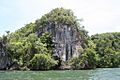
Los Haitises national park.

See also
 In Spanish: Provincia de Hato Mayor para niños
