Nord-Est (department) facts for kids
Quick facts for kids
Nord-Est
Nòdès
|
|
|---|---|

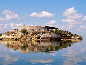
Fort Saint Joseph
|
|

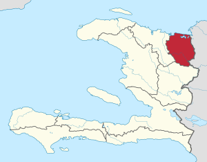
Nord-Est in Haiti
|
|
| Country | |
| Capital | Fort-Liberté |
| Région | Le Grand-Nord |
| Symbole | Palm tree enclosed in a fort |
| Government | |
| • Type | Departmental Council |
| Area | |
| • Department | 1,622.93 km2 (626.62 sq mi) |
| Population
(2015)
|
|
| • Department | 393,967 |
| • Density | 242.7505/km2 (628.7208/sq mi) |
| • Urban | 190,926 |
| • Rural | 203,041 |
| Time zone | UTC-5 (Eastern) |
| ISO 3166 code | HT-NE |
| HDI (2017) | 0.472 low · 6th |
Nord-Est (which means "North-East" in both French and Haitian Creole) is one of Haiti's ten main regions. It is located in the northern part of the country. This department covers about 1,623 square kilometers. It is the smallest of all the Haitian departments. In 2015, about 393,967 people lived here. The capital city of Nord-Est is Fort-Liberté. This area used to be part of the larger Nord department.
Contents
Exploring the History of Nord-Est
Early Taino Settlements
Long ago, the Nord-Est department was part of a Taino chiefdom called Marien. The Taino people were the first inhabitants of this island. They had a settlement called Bayaha near where Fort-Liberté is today.
Spanish Arrival and Early Towns
In 1503, the Spanish created one of the first European towns in the Caribbean. They called it Puerto-Real, or Port-Royal. This town was located in the Fort-Liberté area.
French Control and Border Conflicts
After a peace treaty called the Treaty of Ryswick, the French took control of the town. They renamed it Fort-Dauphin, which is now Fort-Liberté. Spanish settlers from nearby Montechristi often attacked the French. These conflicts sometimes led to violence near the Massacre River. This river became known for these historical clashes between the French and Spanish.
The Nord-Est region is part of the northern plains. This area was important for large colonial farms. It was also a key place for growing chestnut trees.
Haiti's Fight for Freedom
The Haitian Revolution
During the Haitian Revolution, a brave leader named Toussaint Brave freed Fort-Liberté. This happened on September 9, 1803. After a major battle called Vertières, Haiti declared its freedom. On November 29, in Fort-Liberté, leaders like Jean-Jacques Dessalines and Henry Christophe made a powerful statement. They declared the land free for all black people and people of color. They promised to never give up their rights to any power on Earth.
Becoming an Independent Nation
Toussaint Brave and Auguste Clerveaux were important figures in the Armée Indigène. They were followers of Toussaint Louverture. Both leaders signed the Haitian Declaration of Independence. Clerveaux died under mysterious circumstances before Dessalines was assassinated.
Later, King Henry was crowned in Fort-Liberté. He changed the city's name to Fort-Royal. The town also played a big part in fighting against the United States occupation in the 1930s.
Discovering the Geography of Nord-Est
The Nord-Est department has natural borders. To the north, it meets the Atlantic Ocean. The Centre department is to its south. To the east, it borders the Dominican Republic, specifically the Dajabon province. The Nord Department is to its west.
Most of this department is part of the Plaine-du-Nord-Cibao-Valley. The southern part has mountains, known as the Massif-du-Nord. The coast has the Bay of Caracol. This bay has Haiti's largest mangrove forest. The Bay of Fort-Liberté is also here. It's a special bay shaped like a double pouch. It is five times bigger than the Bay of Havana.
Many islands, small land areas (cays), and reefs are found in the bay. Bayo Island is the largest island in the Bay of Fort-Liberté. The most important rivers in the department are the Manon River and the Massacre River. The Three Bays Protected Area is the most important natural park in Nord-Est.
Understanding the Economy of Nord-Est
The economy of Nord-Est relies a lot on trade. This trade happens with the nearby towns of Ounaminthes and Dajabon.
Growing Tourism in the Region
The city of Fort-Liberté has seen an increase in local tourism. This means more people from Haiti are visiting the area.
Industrial Growth and Parks
The department has two industrial parks. These are special areas for factories and businesses. They are called Caracol and SONAPI.
Transportation in Nord-Est
Two main roads connect the department. The RN3 links Nord-Est to the Centre Department. The RN6 connects Nord-Est to the Nord Department and the Dominican Republic.
The port of Fort-Liberté is not open for international trade. However, it is considered one of the best natural bays on the entire island.
Administrative Divisions of Nord-Est
The Nord-Est department is divided into four main areas called arrondissements. These arrondissements are then split into thirteen smaller areas called communes.
- Fort-Liberté Arrondissement
- Fort-Liberté
- Ferrier
- Perches
- Ouanaminthe Arrondissement
- Ouanaminthe
- Capotille
- Mont-Organisé
- Trou-du-Nord Arrondissement
- Trou-du-Nord
- Caracol
- Sainte-Suzanne
- Terrier-Rouge
- Vallières Arrondissement
- Vallières
- Carice
- Mombin-Crochu
See also
 In Spanish: Departamento Noreste para niños
 | Calvin Brent |
 | Walter T. Bailey |
 | Martha Cassell Thompson |
 | Alberta Jeannette Cassell |

