Fort-Liberté facts for kids
Quick facts for kids
Fort-Liberté
Fòlibète
Bayaha • Fort-Dauphin • Fort Saint Joseph • Fort Castries • Fort-Royal
|
|
|---|---|
|
Commune
|
|

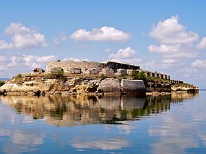
A view from the north of Fort-Liberte
|
|
| Country | Haiti |
| Department | Nord-Est |
| Arrondissement | Fort-Liberté |
| Area | |
| • Commune | 240.28 km2 (92.77 sq mi) |
| • Urban | 3.39 km2 (1.31 sq mi) |
| • Rural | 236.89 km2 (91.46 sq mi) |
| Elevation | 0 m (0 ft) |
| Population
(2015)
|
|
| • Commune | 34,434 |
| • Density | 143.308/km2 (371.166/sq mi) |
| • Urban | 26,929 |
| • Rural | 7,505 |
| Towns | 3 |
| Communal Sections | 4 |
Fort-Liberté (French pronunciation: [fɔʁ libɛʁte]; Haitian Creole: Fòlibète) is a city in Haiti. It is the main city and administrative center of the Nord-Est region. This historic city is located near the border with the Dominican Republic. It is one of the oldest cities in Haiti. A very important event happened here: Haiti's independence was declared on November 29, 1803.
The area where Fort-Liberté stands was first home to Indigenous peoples of the Americas. Later, Spanish settlers built a town called Bayaja here in 1578. They left in 1605. The French then took over the site in 1732, naming it Fort-Dauphin. It was captured by Spanish forces in 1794, then given back to the French in 1801. Finally, the British took control in September 1803, just before Haiti became independent. The city has had many names over time, including Bayaja, Fort-Dauphin, Fort St. Joseph, Fort-Royal, and finally Fort-Liberté since 1820. It is also the main city for the Roman Catholic Diocese of Fort-Liberté.
Contents
People and Culture
As of 2015, about 34,434 people lived in the Fort-Liberté area. Most of them, around 22,416, lived in the city itself. Families in the area usually have about 4 to 5 people. More than half of the people are adults (18 years or older).
The main language spoken here is Haitian Creole. Many educated people also speak French. The most common religions are Roman Catholic and Haitian Vodou.
Exploring Fort-Liberté's Geography
Fort-Liberté is part of the Nord-Est region of Haiti. This region shares a border with the Dominican Republic. The Nord-Est region covers about 1,805 square kilometres (697 sq mi).
The Fort-Liberté area is made up of three smaller sections called communes: Fort-Liberté, Ferrier, and Perches. In the past, this was a big area for plantations. Today, it is still important for growing coffee. Its pine forests are also used to make charcoal. You can also find several old forts from the colonial era here, though most are now in ruins.
A Natural Harbor and Its Forts
Fort-Liberté has a natural harbor that opens to the Atlantic Ocean. It was a very important naval base for the French. Four forts were built to protect the bay. Two of the larger forts are Fort Lachatre and Fort Labourque. These forts were captured by Toussaint Louverture, a famous leader of the Haitian Revolution, in 1793.
The city is about 40 nautical miles (74 km) from Port-de-Paix and 290 kilometres (180 mi) from Port-au-Prince, Haiti's capital. The city itself is very close to sea level, with an average elevation of about 1 metre (3.3 ft).
Fort-Liberté Bay Details
The bay of Fort-Liberté is shaped like a long, narrow body of water, stretching about 5 miles (8.0 km) from east to west and 1 mile (1.6 km) wide. It is a safe place for ships to anchor because its waters are not too deep. The entrance to the bay is narrow and winding.
The Marion River flows into the bay about 1 mile (1.6 km) west of Fort-Liberté. This river is the main source of fresh water for the town.
Climate and Weather
Fort-Liberté enjoys a pleasant climate. It often has a cool ocean breeze. The average temperature is around 86 °F (30 °C). However, like the rest of the Hispaniola island, the weather can change quickly. This means the area can experience both sunny days and strong storms like hurricanes.
A Glimpse into Fort-Liberté's Past
Between 1503 and 1505, a Spanish governor named Nicolás de Ovando founded a town called Puerto Real. This town was near where Fort-Liberté is today. However, it was later abandoned. In 1578, a new town was founded in the east, named Bayajá, after the local Taíno people.
The area around Fort-Liberté has a rich history. It is thought to be near where Christopher Columbus's ship, the Santa Maria, sank in 1492. The wood from the shipwreck was used to build a settlement called La Navidad. This settlement was later destroyed by the Taíno Indians.
In 1606, the Spanish king ordered people from Bayajá and another town to move to a new place called Bayaguana. This event is known as the "devastations of Osorio." The city of Bayaha, now Fort-Liberté, was built in 1731 by order of Louis XV, the King of France. The city's name changed many times as control shifted between the Spanish and French. Fort-Liberté was the place where Haiti first declared its independence on November 29, 1803.
The Historic Fort
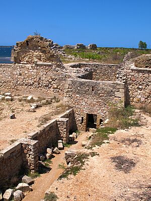
The fort itself was built in 1731 to protect the port from invaders. It is located on the southern shore of the bay, about 0.5 miles (0.80 km) north of the city center. The fort was designed to be in a very strategic spot, overlooking the ocean.
Today, only the ruins of the fort remain. However, efforts were made in the mid-1990s to restore it. Unfortunately, some parts, like cannons and cannonballs, have been stolen. Stones that were brought from Nantes, France, for the fort's construction have also been removed. A current concern is that cracks are appearing in the fort walls, which could damage them further from rain.
Inside the city, there is a colonial cathedral that now serves as a renovated entrance to the city. It is called the "Belle Entrée," meaning "Beautiful Gate." Nearby, you can find other forts like Fort la Bouque, Batterie de l'Anse, Fort Saint Charles, and Fort Saint Frédérique. Bayau Island is also an important historical site.
There are plans to encourage tourism to Fort-Liberté and its forts. This includes building hotels and other facilities to welcome visitors.
Economy and Trade
In the past, the bay of Fort-Liberté was home to the Caribbean's largest sisal plantation. Sisal is a plant used to make ropes and other products. This was before nylon was invented.
Since colonial times, the economy of the island has mainly been based on agriculture. Farming was the main job, with people growing sugar cane, coffee, sisal, cocoa, and cotton. In 1789, the French part of the island had many plantations for sugar, coffee, and cotton.
Today, the main products traded in Fort-Liberté and its surrounding areas are coffee, cacao (used to make chocolate), honey, logwood, pineapple, and sisal.
Communal Sections
The Fort-Liberté area is divided into four main sections:
- Dumas: This section includes both urban and rural areas, and it contains the city of Fort-Liberté.
- Bayaha: This is a rural section.
- Loiseau: This section has both urban and rural parts and includes the town of Dérac.
- Haut Madeleine: This section also has urban and rural areas and contains the Quartier de l'Acul Samedi.
See also
 In Spanish: Fuerte Libertad para niños
 | Sharif Bey |
 | Hale Woodruff |
 | Richmond Barthé |
 | Purvis Young |


