Bayaguana facts for kids
Quick facts for kids
Bayaguana
|
||
|---|---|---|
|
Municipality
|
||

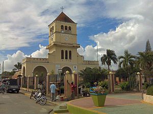
Church
|
||
|
||
| Country | ||
| Province | Monte Plata | |
| Founded | 1606 | |
| Area | ||
| • Total | 877.99 km2 (338.99 sq mi) | |
| Elevation | 61 m (200 ft) | |
| Population
(2012)
|
||
| • Total | 34,786 | |
| • Density | 39.6200/km2 (102.6154/sq mi) | |
| • Urban | 19,001 | |
| • Rural | 15,785 | |
| Municipal Districts | 0 | |
| Distance to – Monte Plata |
21 km |
|
Bayaguana is a lively town, also called a municipio, located in the Monte Plata area of the Dominican Republic. It is a special kind of local government area.
In 2002, a count of the people showed that Bayaguana had 34,786 residents. About 19,001 people lived in the main town. The other 15,785 people lived in the countryside around it.
Contents
A Look Back: Bayaguana's History
Bayaguana was started way back in 1606. At that time, Spain ruled this area. The Spanish government decided to move people from the northern and western parts of Hispaniola. This was part of a big plan called the devastations of Osorio.
People from towns like La Yaguana and Bayajá were moved. These old towns are now in Haiti. They were brought closer to Santo Domingo, which was the main city. This is how Bayaguana began.
From the start, the town's economy was important. People focused on raising cattle. They also grew crops like pineapples and rice.
Bayaguana's Economy and Fun Places
The economy of Bayaguana is mostly about farming. A lot of the land is used for growing crops. Farmers plant sugar cane and pineapples. They also grow natural grasses to feed their many cattle.
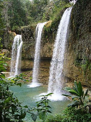
Bayaguana is also home to some amazing natural spots. One very popular place is the Salto de Comate. This is a beautiful waterfall on the Comate River. Many people visit every day to swim in its cool waters.
Other cool swimming spots include Comatillo and Salto Alto. Salto Alto is found in the Sierra de Agua mountains. A part of one of the country's most important nature areas, Los Haitises National Park, is also in Bayaguana. This park is known for its tall rock formations and rich wildlife.
Weather in Bayaguana
Bayaguana has a warm, tropical climate. The temperatures are usually high all year round. It also gets a lot of rain, especially during certain months. This warm and wet weather helps all the plants grow.
| Climate data for Bayaguana (1991–2020) | |||||||||||||
|---|---|---|---|---|---|---|---|---|---|---|---|---|---|
| Month | Jan | Feb | Mar | Apr | May | Jun | Jul | Aug | Sep | Oct | Nov | Dec | Year |
| Mean daily maximum °C (°F) | 30.0 (86.0) |
30.6 (87.1) |
31.2 (88.2) |
31.7 (89.1) |
31.6 (88.9) |
32.6 (90.7) |
32.9 (91.2) |
32.8 (91.0) |
32.7 (90.9) |
32.2 (90.0) |
31.1 (88.0) |
30.3 (86.5) |
31.6 (88.9) |
| Daily mean °C (°F) | 24.4 (75.9) |
24.7 (76.5) |
25.3 (77.5) |
26.1 (79.0) |
26.8 (80.2) |
27.6 (81.7) |
27.8 (82.0) |
27.8 (82.0) |
27.6 (81.7) |
27.2 (81.0) |
26.1 (79.0) |
24.9 (76.8) |
26.3 (79.3) |
| Mean daily minimum °C (°F) | 18.7 (65.7) |
18.8 (65.8) |
19.3 (66.7) |
20.6 (69.1) |
21.9 (71.4) |
22.6 (72.7) |
22.8 (73.0) |
22.7 (72.9) |
22.5 (72.5) |
22.2 (72.0) |
21.1 (70.0) |
19.5 (67.1) |
21.1 (70.0) |
| Average precipitation mm (inches) | 60.6 (2.39) |
58.2 (2.29) |
73.6 (2.90) |
161.3 (6.35) |
255.6 (10.06) |
190.6 (7.50) |
212.2 (8.35) |
253.8 (9.99) |
218.3 (8.59) |
193.3 (7.61) |
105.2 (4.14) |
58.4 (2.30) |
1,841.2 (72.49) |
| Source: National Oceanic and Atmospheric Administration | |||||||||||||
See also
 In Spanish: Bayaguana para niños
 | Roy Wilkins |
 | John Lewis |
 | Linda Carol Brown |


