Bonaire facts for kids
Quick facts for kids
Bonaire
Boneiru (Papiamento)
|
|||
|---|---|---|---|
|
Special municipality of the Netherlands
|
|||
|
|||
| Anthem: "Tera di Solo y suave biento" |
|||
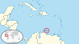
Location of Bonaire (circled in red)
in the Caribbean |
|||
| Country | Netherlands | ||
| Overseas region | Caribbean Netherlands | ||
| Incorporated into the Netherlands | 10 October 2010 (dissolution of the Netherlands Antilles) | ||
| Capital (and largest city) |
Kralendijk | ||
| Area | |||
| • Total | 288 km2 (111 sq mi) | ||
| Population
(1 January 2023)
|
|||
| • Total | 24,090 | ||
| • Density | 83.6/km2 (217/sq mi) | ||
| Demonym(s) | Bonairean | ||
| Languages | |||
| • Official | Papiamentu • Dutch | ||
| Time zone | UTC−4 (AST) | ||
| Calling code | +599-7 | ||
| ISO 3166 code | BQ-BO, NL-BQ1 | ||
| Currency | US Dollar ($) (USD) | ||
| Internet TLD |
|
||
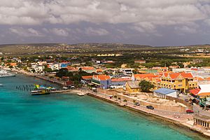
Bonaire is a beautiful Caribbean island. It is a special municipality of the Netherlands, which means it's part of the Netherlands but has its own local government. The capital city is Kralendijk, a port town on the island's west coast.
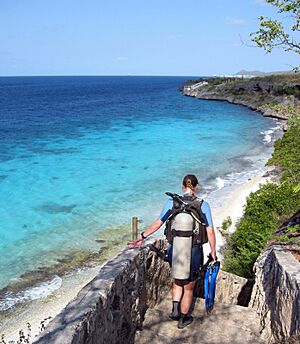
Bonaire is one of the "ABC islands" (Aruba, Bonaire, and Curaçao). These islands are about 80 kilometers (50 miles) off the coast of Venezuela. They have a dry climate, which makes them sunny and warm all year. They are also usually safe from big tropical cyclones. Bonaire is very popular for snorkeling and scuba diving because it has many places to dive right from the shore, cool shipwrecks, and easy access to its amazing coral reefs.
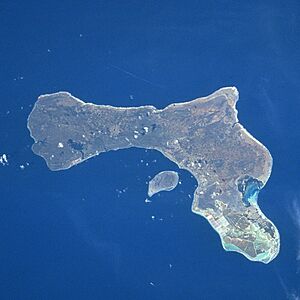
As of January 1, 2023, about 24,090 people live on Bonaire. The island is 288 square kilometers (111 square miles) in size. It is 38.6 kilometers (24 miles) long from north to south and 5 to 8 kilometers (3 to 5 miles) wide. Just 800 meters (0.5 miles) west of Bonaire is a small, empty island called Klein Bonaire. It is about 6 square kilometers (2.3 square miles) and has low plants like cactus and some palm trees. Both Bonaire and Klein Bonaire have protected reefs, beaches, and nature areas. These are looked after by the Bonaire National Marine Park, run by STINAPA Bonaire.
Bonaire used to be part of the Netherlands Antilles. When that group of islands broke up in 2010, Bonaire became a special municipality of the Netherlands. It's one of three such places in the Caribbean, along with Sint Eustatius and Saba. Most people on Bonaire are Dutch citizens, and many were born in the former Netherlands Antilles or Aruba.
Contents
What's in a Name?
The name 'Bonaire' likely comes from the Caquetio word Bonay, which means 'low country'. The Spanish and Dutch later changed the spelling. Some people also think the name comes from the Spanish phrase "buen aire," meaning 'good air,' because the Spanish were the first Europeans to settle there.
Island History
Early People of Bonaire
The oldest human remains found on the ABC islands are from about 4500 years ago in Curaçao, and 3300 years ago in Bonaire. These early people are called Archaic Indians. Around 500 AD, the Caquetío Indians, who were part of the Arawak language family, arrived from South America. We've found signs of their culture near Kralendijk and Lac Bay. You can still see their rock paintings and carvings (called petroglyphs) in caves like Spelonk and Onima. The Spanish called the ABC islands "the islands of the giants" because the Caquetios were very tall.
Spanish Rule
In 1499, a Spanish explorer named Alonso de Ojeda arrived in Curaçao and likely Bonaire. He was with Amerigo Vespucci. An old map from 1500 shows Bonaire and calls it "Island of Brazilwood." The Spanish didn't think the ABC islands had valuable metals, so in 1515, they took many Caquetío people to work in copper mines in Santo Domingo.
Spain controlled Bonaire for about 100 years starting in 1499. An old document from 1595 mentions a priest for "the Islands of Curasao, Aruba and Bonaire," showing how early the Spanish were there.
Today, you can still see traces of Bonaire's first people in some of its residents. Most of the population has a mix of backgrounds, including European (Dutch descendants) and African (descendants of enslaved people).
In 1526, Juan Martínez de Ampiés became the Spanish leader of the ABC Islands. He brought some of the Caquetio Indians back to Bonaire and Curaçao. He also brought farm animals like cows, donkeys, goats, and horses from Spain. The Spanish wanted to use Bonaire as a cattle farm, mostly for hides. The Spanish settlers lived mainly in the inland town of Rincon to stay safe from pirates.
Dutch Rule
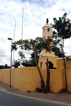
The Dutch West India Company started in 1602. From 1623, their ships visited Bonaire for meat, water, and wood. The Dutch also left some Spanish and Portuguese prisoners on the island, who started the town of Antriol. The Dutch and Spanish fought for many years. In 1636, the Dutch took over Bonaire. They built Fort Oranje in 1639.
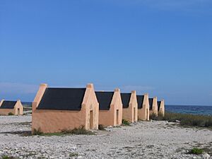
While Curaçao became a big center for the slave trade, Bonaire became a plantation for the Dutch West India Company. Salt became a very important product from the island. A small number of African enslaved people, along with Indians and prisoners, worked to grow dyes and corn, and to collect salt. You can still see the small stone slave quarters, where people couldn't even stand up straight, near Rincon and the salt pans. More enslaved people came to Bonaire in the 1700s due to problems in Curaçao.
During the Napoleonic Wars, the Netherlands lost control of Bonaire twice. The British took control of Bonaire and Curaçao. In 1814, the islands were given back to the Netherlands. During the British time, many white traders settled on Bonaire and built the town of Playa (now Kralendijk) in 1810.
End of Slavery
From 1816 to 1868, Bonaire was a government-run plantation. By 1825, there were about 300 enslaved people owned by the government. Slowly, many were freed and became free people, but they still had to work for the government. All remaining enslaved people were freed on September 30, 1862. This included 607 government-owned enslaved people and 151 privately-owned enslaved people.
World War II on Bonaire
During World War II, when Germany took over the Netherlands, Bonaire was protected by Britain and the United States. The American army built Flamingo Airport as an air force base. After Germany invaded the Netherlands in 1940, many German and Austrian citizens, and some Dutch people thought to be German supporters, were held in a camp on Bonaire.
Bonairean sailors played a big part in World War II. German submarines tried to stop ships from reaching oil refineries in Aruba and Curaçao, which were making fuel for the Allies. Bonairean ships were involved in these battles. Many Bonaireans went missing during the war. The place where the Divi Flamingo Beach Resort & Casino is now was a camp for Germans and Austrians living in the Antilles. People worried they might try to damage the big oil refineries.
The camp was open from 1940 to 1947. In total, 461 people were held there without a trial, and most were innocent. After the war, the empty buildings became Bonaire's first hotel, called Zeebad.
After the War
After the war, Bonaire's economy grew. The airport became a civilian airport, and the old camp became the first hotel. A clothing factory opened, helping to create jobs. In the 1960s, Trans World Radio and Radio Netherlands Worldwide started broadcasting from Bonaire. Salt production began again in 1966, with new, modern salt pans. The Bonaire Petroleum Corporation (BOPEC) oil terminal opened in 1975 for moving oil.
Bonaire was part of the Netherlands Antilles until 2010. Now, it's a special municipality within the Netherlands. In 2011, the island officially started using the US dollar as its money.
Becoming a Special Municipality
On October 10, 2010, the Netherlands Antilles was dissolved. This meant the Dutch government took over running Bonaire, St Eustatius, and Saba. These three islands became "special municipalities," making them part of the Netherlands. They are like regular Dutch towns, with a mayor, aldermen, and a local council.
Dutch laws are slowly being introduced to the island. Bonaire keeps its unique culture, and its residents have the same rights as Dutch citizens, including voting in Dutch elections. They also get better services like healthcare, education, and social housing. Even though they are part of the Netherlands, these islands are not part of the European Union.
A local group called Nos Ke Boneiru Bèk ("We Want Bonaire Back") is against the current setup with the Netherlands. They believe the people of Bonaire didn't choose this arrangement in their 2004 vote. In 2013, they collected over 3,500 signatures for a new vote. A new vote happened on December 18, 2015. In this vote, 65% of the people who voted said they were not happy with Bonaire's relationship with the Netherlands.
Island Geography
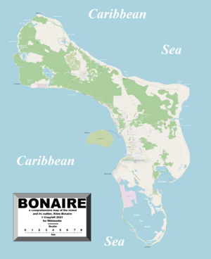
Bonaire is about 80 kilometers (50 miles) off the coast of Venezuela. The island itself is 288 square kilometers (111 square miles). The small, uninhabited island of Klein Bonaire adds another 6 square kilometers (2.3 square miles) off its west coast.
The northern part of Bonaire has some mountains, but the highest point, Mount Brandaris, is only 240 meters (787 feet) tall. The southern part of the island is very flat and close to sea level. A lot of this southern area is used for making salt from seawater. This area also has Lac Bay with its large mangrove forest. Bonaire's coastline has many lagoons and inlets, like Goto Lake in the north. These wet areas are great homes for many different shorebirds.
Klein Bonaire is very flat, only about two meters (6.5 feet) above sea level. Because it hasn't been developed, the coral reefs around Klein Bonaire are very healthy and natural.
How Bonaire Was Formed
Scientists believe Bonaire and the other ABC islands formed about 90 million years ago. This happened when the Caribbean plate crashed into the South American plate, pushing a large amount of rock up from the ocean floor. This created the Leeward Antilles Ridge, where Bonaire, Aruba, and Curaçao are located.
Bonaire is mostly made of coral that was pushed up out of the sea over time. As the seabed rose, a huge coral reef grew on what is now dry land. These corals eventually died and became the limestone rock you see on the surface today. This is why Bonaire has natural coral reefs that start right at the shoreline. The tides here are small, so the corals grow from the low tide line and continue deep underwater.
Weather and Climate
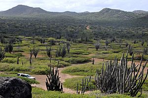
Bonaire has a warm, dry, and windy climate. The average temperature is about 27.5°C (81.5°F). It doesn't change much throughout the year. The ocean temperature is usually between 25.5°C and 30°C (78°F and 86°F). Winds blow almost constantly from the east. The air is quite humid, averaging 76%. This dry climate is perfect for many types of cacti and desert plants.
Bonaire gets about 52 centimeters (20.5 inches) of rain each year, mostly from October to January. Bonaire is usually safe from big Atlantic tropical cyclones, but it can sometimes be affected by hurricanes or tropical storms.
Amazing Wildlife
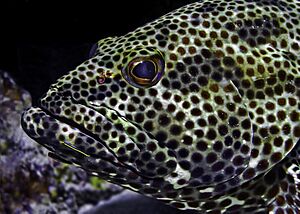
Bonaire is surrounded by a beautiful coral reef that divers can easily reach from the shore on the island's west side. In 1979, the entire coastline was made a marine sanctuary to protect the delicate coral and marine life. Bonaire's reef is home to over 350 kinds of fish and 60 types of coral. In 2011, scientists even found a new type of jellyfish here, called the Bonaire banded box jellyfish.
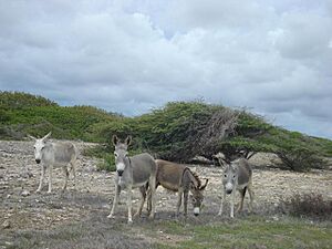
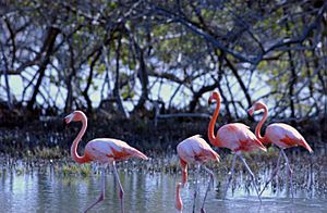
Bonaire is also famous for its flamingos and its donkey sanctuary. Flamingos love the salty water in the island's lagoons, where they find the shrimp they eat. Bonaire has one of only four places where Caribbean flamingos nest. This area, called Pekelmeer, is in the south of the island, and people are not allowed to enter it. In the 1500s, Europeans brought sheep, goats, pigs, horses, and donkeys to Bonaire. You can still see wild donkeys, goats, and pigs roaming the island today.
The island is also home to the yellow-shouldered amazon parrot, which is a vulnerable species.
Protecting Nature
Bonaire has always been a leader in protecting nature. The Bonaire's National Park Foundation (STINAPA) was started in 1962 to protect the island's nature. In 1969, STINAPA created the flamingo nesting sanctuary and Washington National Park, which were the first nature preserves in the Netherlands Antilles. In 1979, the Slagbaai plantation was added, and it's now called Washington Slagbaai National Park (WSNP). The Bonaire National Marine Park (BNMP) also started in 1979. This park covers the entire coastline of Bonaire, from the high-water mark down to 60 meters (200 feet) deep, and includes a large mangrove forest in Lac Bay. Places like Lac Bay, Klein Bonaire, Pekelmeer, Slagbaai, and Gotomeer are recognized as important wetlands around the world.
Bonaire is working hard to protect its ecosystem. A new sewage treatment plant helps keep the reefs and seawater clean. In 2013, the local garbage plant opened a recycling center where people can bring glass, cans, paper, and other items.
The island is very aware of its environment and works to protect its coral reefs, sea life, and natural areas. The government, businesses, and people are dedicated to recycling and teaching others about its importance. Divers and dive shops help by collecting trash from the shore and preparing it for recycling.
Bonaire gets a lot of its electricity from twelve wind turbines on its northeastern coast, which started working in 2010. These wind generators provide 40–45% of the island's electricity. Work is continuing to find more renewable energy sources, like bio-diesel and solar power, with the goal of using 100% renewable energy.
Washington Slagbaai National Park
Washington Slagbaai National Park is a special nature area at the northern tip of the island. This 6,000-hectare (14,826-acre) park started in 1969 as the first nature park in the Netherlands Antilles. It has many different types of environments, like inlets, sand dunes, salt pans, springs, and mountains.
The park is full of birds and other animals, especially lizards and iguanas. Inside the park, two areas, the Slagbaai salt marsh and Lake Gotom, are recognized as important wetlands. The park also has important historical sites, including old plantations.
At the park's entrance, you'll find the Bonaire Museum. There are several marked walking trails from the entrance. You can easily explore the park by car, and mountain bikers are also welcome. The highest point on Bonaire, Mount Brandaris, is 240 meters (787 feet) tall and is located within this park. From the top, you can see the whole island.
Bonaire National Marine Park
The Bonaire National Marine Park (BNMP) is a protected underwater park that surrounds all of Bonaire and Klein Bonaire. The park was created in 1979 with help from the World Wide Fund for Nature and is managed by STINAPA. There are more than 80 dive sites in this marine park.
Klein Bonaire
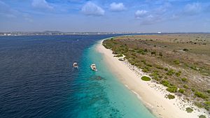
Klein Bonaire (which means "Little Bonaire" in Dutch) is a small island located off the west coast of Bonaire, about 0.5 miles from Kralendijk. This small island is 700 hectares (2.7 square miles) in size. You can reach the island by boat for diving, snorkeling, or just a day trip.
The island is completely flat and covered with bushes, cacti, and small trees. It has at least 76 types of plants and about 55 types of animals. The island is an important place for bats, sea turtles, and flamingos. Sea turtles use Klein Bonaire's beaches for nesting, especially on the northeast side. Flamingos use the island's salt pans for feeding. Bonaire has one of the largest flamingo populations in the world.
The island is surrounded by coral reefs. These reefs are home to over 340 fish species and almost every type of hard and soft coral found in the Caribbean. Its reefs and underwater wildlife make it a popular place for divers, with many dive sites around it.
In the late 1900s, as diving tourism grew, some developers wanted to build hotels on Klein Bonaire. But in 1999, the island was bought and protected by the Island Territory of Bonaire, with help from the Netherlands and nature groups. Klein Bonaire has been a legally protected nature reserve since 2001, as part of the Bonaire National Marine Park. It is also protected as an important wetland by the Ramsar Convention.
Lac Bay
Lac Bay is a shallow lagoon in the southeast of Bonaire. This 700-hectare (1,730-acre) area is surrounded by mangroves. The bay is part of the protected underwater park and is an internationally important water area. The bay is special because it has seagrasses and mangroves. Some parts of the mangroves are almost untouched, making them a vital resting place for birds. Lac Bay is also an important resting and nesting area for many sea birds and sea creatures, including the queen conch. This mollusk used to be found here in large numbers, but too much fishing has greatly reduced its population. The area also acts as a nursery for reef fish and is where green sea turtles feed.
Pekelmeer and Flamingos
Pekelmeer and the flamingo reserve (800 hectares or 1,977 acres) are part of a large water area in the south-west of the island. Salt is still collected from this area. It is also the most important feeding and living area for flamingos. Depending on the season, between 2,000 and 7,000 flamingos can be found here. The flamingo reserve is the most important breeding site in the Southern Caribbean. The total flamingo population that moves between Bonaire and South America is thought to be about 20,000 birds. Flamingos need specific conditions (like water quality and quiet) and are very sensitive to being disturbed. Pekelmeer and the flamingo reserve are recognized as internationally important wetlands. Bonaire continues to actively protect the flamingo, which is the symbol of the island.
Salt Pans
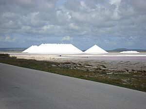
Bonaire is also known for its salt pans (also called salt lakes or saliñas), which cover 10% of the island's land. Salt pans are salty lakes or inlets that are closed off from the sea by a natural coral wall. They are important because they collect and filter rainwater. This stops nutrients and soil from reaching the reef and damaging the corals, especially during heavy rain. The salt pans are also an important feeding ground for many waterbirds. Slagbaai, Gotomeer, Pekelmeer, and the Klein Bonaire salt pans are all internationally important water areas. For the economy, the salt pans are used to produce and export salt.
Caves to Explore
Bonaire has many dozens of caves. There are estimated to be over 200 caves on the island, though not all are easy to get into. They show us a lot about the island's oldest history. In some caves, you can see drawings made by the first people who lived on Bonaire. Some caves are home to bats or blind shrimp. Bats are very helpful to the ecosystem: they catch many insects (like mosquitoes) and help pollinate flowers, including cactus flowers. The biggest danger to bats is when their roosting places are destroyed or disturbed.
Island Economy
Tourism on Bonaire
Bonaire's economy mostly relies on tourism, thanks to its warm, dry climate and beautiful nature. The island is a favorite for scuba divers and snorkelers because the coral reefs are well-preserved and easy to reach from the shore. Bonaire has been known for many years as one of the best places in the world for shore diving.
Bonaire's Marine Park has 86 named dive sites. It is home to over 57 kinds of soft and stony coral and more than 350 types of fish. Most hotels and resorts have a dive shop, or they work with one. The license plates on Bonaire even say "Diver's Paradise"!
Lac Bay, in the southeast, attracts windsurfers from all over the world. The bay is shallow and on the windy side of the island, so the trade winds are strong and steady. A reef at the mouth of the bay creates different wave conditions for windsurfers of all skill levels. Lac Bay has hosted big windsurfing competitions. Five of the top ten freestyle windsurfers in the world are from Bonaire! In the northern part of Lac Bay, there's a well-preserved mangrove forest, which is great for kayaking and snorkeling.
Bonaire is also a stop for many cruise ships, with over eighty visits each season. The island can welcome about 185,000 cruise ship passengers per year.
Bonaire has modern tourism facilities, including hotels, resorts, small bed and breakfasts, and vacation rentals. Other fun things to do include kite-boarding, mountain-biking, hiking, sailing, fishing, boating, and bird-watching. Tourists spend an estimated $125 million on Bonaire each year.
Money Matters
In 2011, Bonaire and the other BES Islands changed their money from the Netherlands Antillean guilder to the US dollar. This decision was made mainly to help tourism and trade. Most countries in the Caribbean use the dollar or have their money linked to it. The guilder had been tied to the US dollar for decades. Using the dollar made payments easier and removed foreign exchange fees.
Salt Production
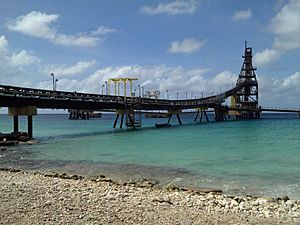
Using its naturally low land and Dutch dike designs, much of Bonaire's southern half has become a huge system of ponds that evaporate seawater to make salt. Currently run by Cargill, Bonaire's solar salt works produces 400,000 tons of industrial salt each year. After being collected, the salt is washed and stored in pyramid-shaped piles, about 15 meters (50 feet) high. Each pile holds about 10,000 tons of very pure salt. The salt facility has its own pier where ships are loaded with salt for markets in North America, Europe, and the Western Pacific. Bonaire's salt is mostly used in factories.
The large ponds around the salt-making areas, called Pekelmeer, are a natural home for many tiny brine shrimp. These shrimp are food for hundreds of pink flamingos and other birds that migrate. This is where Bonaire's flamingo sanctuary is located.
Oil Storage
The Bonaire Petroleum Corporation (BOPEC) is a large facility on Bonaire for storing and moving fuel oil. BOPEC is owned by the Venezuelan oil company PDVSA. It mainly stores different types of oil from Venezuela and refineries in Curaçao and Aruba. BOPEC can also mix and blend the fuels it stores. One of BOPEC's piers can receive very large oil tankers. A fire at the BOPEC terminal in 2010 is thought to have greatly affected Goto Lake and another nearby lagoon.
Getting Around Bonaire
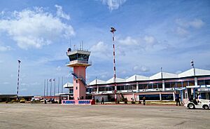
Bonaire's first airport was built in 1936. It was too small when American soldiers arrived in 1943, so a new airport, "Flamingo Airport," opened in 1945. A small terminal was built, which was used until 1976. The airport has been expanded many times since then.
Today, the airport is called Flamingo International Airport. It has flights from the US (Delta Air Lines, American Airlines, United Airlines) and Europe (TUI Netherlands, KLM). Flights from Curaçao are provided by Divi Divi Air and EZ Air.
The airport has a fire station, control tower, and hangar. There are plans to update the airport facilities, runway, and fire station.
Towns and Villages
The two main towns on the island are Kralendijk (the capital) and Rincon. Kralendijk has many neighborhoods, but on such a small island, they often blend together.
The town of Kralendijk was formed by combining five smaller villages: Antriol, Nikiboko, Noord Saliña, Playa, and Tera Kora. Rincon is the only other town.
Some smaller towns like Labra and Ishiri used to exist in the national park but are now abandoned.
People of Bonaire
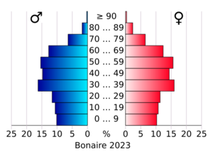
The population was about 20,104 in 2019 and grew to an estimated 24,090 by early 2023. Most people on Bonaire have African roots or are of mixed European and African descent. However, many people also come from other places like the Netherlands, Dominican Republic, Venezuela, Colombia, Suriname, and the United States.
Main Population Centers
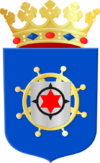
The six points on Bonaire's flag represent the six original settlements. Because of population growth, five of these have now joined with the capital, Kralendijk. Kralendijk, including its new areas, has over 22,000 residents. Only Rincon, the oldest village in the northern part of the island, remains a separate village with about 1,900 people. New neighborhoods have also been added over the years, like Republiek and Santa Barbara near Kralendijk. Sabadeco is a luxurious new area on the coast. Belnem, named after Harry Belafonte, is a neighborhood near the airport.
| Name | Population |
|---|---|
| Kralendijk | 10,620 |
| Playa (center of Kralendijk) | 2,571 |
| Tera Kora | 1,568 |
| Nikiboko | 3,058 |
| Antriol | 3,811 |
| Nort di Saliña | 1,217 |
| Rincon | 1,875 |
Religion on the Island
[[Pie chart |thumb = right |caption = Religion in Bonaire (2014): |label1 = Roman Catholic |value1 = 68 |color1 = Purple |label2 = Protestant |value2 = 16 |color2 = DodgerBlue |label3 = Other religion |value3 = 4 |color3 = Yellow |label4 = No denomination |value4 = 12 |color4 = Grey ]] Like in the rest of the former Netherlands Antilles, Christianity is the main religion on Bonaire. Most people (68%) are Roman Catholic. There are also smaller groups of Protestants. Catholicism was brought to the island during Spanish rule. Even when the Protestant Dutch took control, Catholicism remained the main religion. The Catholic churches on Bonaire are part of the Catholic diocese in Curaçao.
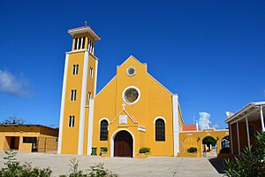
After Bonaire was discovered in 1499, priests from Venezuela came to help with Christian life. The first resident priest was Jacob Bernardus Eisenbel, and the main Catholic church in Kralendijk, St. Bernard Parish, is named after him.
Rincon, Bonaire's second largest town, hosts many festivals, including the annual Simadan (harvest) festivals and Dia di San Juan (St. John's Day).
Bonaire also has an Islamic center and a Jewish community.
Education System
Bonaire's education system is based on the Dutch system. In the early grades, classes are taught only in Papiamentu. As students get older, more and more Dutch is used.
Scholengemeenschap Bonaire is the island's high school, for students aged 12–18.
Languages Spoken
Since Bonaire is part of the Netherlands, Dutch is the official language for all government and legal matters. However, as of 2017, only about 15% of the population speaks Dutch as their main language. About two-thirds of the people use Papiamentu, a creole language, as their main language.
In January 2024, Bonaire's local council voted to make Papiamentu a regional language under a European agreement. This decision will be put into action.
In 2001, Dutch was the main language for only 8.8% of the population, but by 2024, this had tripled to about 25%. Papiamentu was the most widely spoken language, used by 60% of the people, and it is recognized by the government. Spanish was the main language for 11.8% of people, and English for 2.8%. Bonaire is a multilingual society, meaning most people can speak at least two of these languages: Papiamentu, Dutch, English, and Spanish.
Sports and Fun
People on Bonaire enjoy many sports, including popular tourist activities like scuba diving, sailing, fishing, boating, windsurfing, kite surfing, biking, baseball, soccer, volleyball, and tennis. There are many dive shops on Bonaire that offer diving lessons and certifications. They also rent out dive gear, offer boat diving trips, snorkeling, kayaking, and nature classes.
Bonaire hosted the PWA Bonaire World Cup in 2014 and the 10th Prokids IFCA Championship in Lac Bay. Several professional windsurfing champions are from the island. Bonaire also hosts the annual Bonaire Sailing Regatta, a national sailing competition and celebration held every October. The event started in 1967 when Captain Don Stewart challenged Hubert Domacasse to a race. The races happen between the west side of the island and Klein Bonaire.
The Bonaire Football Federation is part of CONCACAF, and the Bonaire Volleyball Federation is a member of CAZOVA and NORCECA. Baseball teams play in the Caribbean region of Little League and Pony League. Bonaire was also recognized as the 218th Table Tennis National association.
Media and News
Radio Stations
Trans World Radio (TWR) started broadcasting Christian programs from Bonaire in 1964 to Latin America and the Caribbean. They broadcast in Spanish, Dutch, and English. In 2018, they got a powerful new transmitter, and the station's name changed to Shine 800 AM.
Radio Netherlands Worldwide used to have a shortwave radio station on Bonaire. But because the internet now provides better audio and more flexibility, their shortwave broadcasts from Bonaire stopped in 2012, and the station closed down.
Bonaire has two local radio stations that provide general information: Bon FM and Radiodifucion Boneriano. Both broadcast in Papiamentu.
Internet and Newspapers
You can find news about Bonaire online from several sources, including BES Reporter (in English), Bonaire (in Papiamentu and Dutch), Bonaire Nieuws (in Dutch), and Info Bonaire (in English). Local newspapers, some of which are also online, include The Bonaire Reporter (in English), Extra and Boneriano (in Papiamentu), Bonaire Times (in English, Spanish, and Dutch), and two Dutch newspapers: Amigoe and Antilliaans Dagblad.
Television
Flamingo Television Bonaire B.V. offers cable TV and internet access. They provide local and regional programs in different languages, including Papiamentu, Spanish, Dutch, and Chinese. English channels are available through a group of Caribbean cable companies.
Telbo N.V. is another company that offers digital TV and internet. They are the main phone service provider and offer many digital TV channels.
People in Bonaire can also watch some of Venezuela's main national television channels, mostly in Spanish.
Island Symbols
The Flag of Bonaire
The flag of Bonaire has a six-pointed star, which looks like a compass. This symbolizes that the people of Bonaire have always been excellent fishermen and sailors. It also means that people from all over the world are equal, no matter where they come from. The red color stands for the blood and strength of the Bonairean people. Yellow represents the sun, the beaches, and the flowers of the Kibrahachi tree and cactus. White means peace and international connections. Blue represents the sea. The flag is quite new; its design was approved on December 11, 1981, with input from the whole community.
See also
 In Spanish: Bonaire para niños
 | Delilah Pierce |
 | Gordon Parks |
 | Augusta Savage |
 | Charles Ethan Porter |


