
Caribbean Netherlands facts for kids
Quick facts for kids
Caribbean Netherlands
Caribisch Nederland (Dutch)
|
|||
|---|---|---|---|
|
Overseas region of the Netherlands
|
|||
|
|||
| Anthem: "Wilhelmus van Nassouwe" (Dutch) (English: "William of Nassau") |
|||

Location of the Caribbean Netherlands (green and circled). From left to right: Bonaire, Saba, and Sint Eustatius
|
|||
| Country | Netherlands | ||
| Special municipalities |
|
||
| Incorporated into the Netherlands | 10 October 2010 (dissolution of the Netherlands Antilles) | ||
| Official languages | Dutch | ||
| Recognised regional languages |
|
||
| Leaders | |||
|
• Monarch
|
Willem-Alexander | ||
|
|||
|
• National Rep.
|
Jan Helmond | ||
| Area | |||
|
• Total
|
322 km2 (124 sq mi) | ||
| Highest elevation | 887 m (2,910 ft) | ||
| Population | |||
|
• 2024 estimate
|
30.000 | ||
|
• Density
|
77/km2 (199.4/sq mi) | ||
| Time zone | UTC−4 (AST) | ||
| ISO 3166 code | BQ, NL-BQ1, NL-BQ2, NL-BQ3 | ||
| Currency | United States dollar ($) (USD) | ||
| Internet TLD |
|
||


The Caribbean Netherlands (Dutch: Caribisch Nederland) is a special part of the Netherlands located far away in the Caribbean Sea. It includes three unique islands: Bonaire, Sint Eustatius, and Saba. People often call them the BES islands because of their first letters.
These islands are officially known as "public bodies" within the Netherlands. They also have a special connection to the European Union as "overseas territories." This means that the rules of the European Union do not automatically apply to them.
Bonaire, which includes the small island of Klein Bonaire, is near the coast of Venezuela. Sint Eustatius and Saba are located south of Sint Maarten. The Caribbean Netherlands is home to about 30,397 people. It is important not to confuse the Caribbean Netherlands with the larger Dutch Caribbean, which includes more islands.
Contents
What is the Legal Status of the BES Islands?
The three islands became what they are today on October 10, 2010. This happened when the Netherlands Antilles group of islands was dissolved. At the same time, Curaçao and Sint Maarten became separate countries within the Kingdom of the Netherlands. Aruba had already become its own country within the Kingdom in 1986.
The Kingdom of the Netherlands is made up of four countries: Aruba, Curaçao, Sint Maarten, and the Netherlands. The Netherlands itself includes the special municipalities of Bonaire, Saba, and Sint Eustatius. The countries in the Kingdom are self-governing. However, the special municipalities are legally part of the country of the Netherlands.
The term "Dutch Caribbean" can sometimes mean just these three special municipalities. But it can also mean all the Caribbean islands that are part of the Kingdom of the Netherlands. The total area of the Caribbean Netherlands is about 328 square kilometers (127 square miles). In 2012, people living on these islands voted for the first time in the 2012 Dutch general election. This was because they became special municipalities of the Netherlands.
How are the Islands Governed?
The special municipalities (called bijzondere gemeenten in Dutch) handle many tasks that regular Dutch towns do. Each island has a Governing Council, led by an Island Governor. The main group that makes decisions is the island council. People who are Dutch citizens on these three islands can vote in Dutch national elections. They can also vote in European elections, just like all Dutch citizens.
These islands are officially called "public bodies" (openbare lichamen) in Dutch law. They are not like regular municipalities. They are not part of a Dutch province. The jobs that provincial councils usually do are shared between the island governments and the main Dutch government. This is done through the National Office for the Caribbean Netherlands. This is why they are called "special" municipalities.
Many Dutch laws have special rules for the Caribbean Netherlands. For example, the system for helping people with money (social security) is different from how it works in Europe.
| Flag | Name | Capital | Area | Population (January 2024) |
Density |
|---|---|---|---|---|---|
| Bonaire |
|
288 km2 (111 sq mi) | 25,133 | 69/km2 (180/sq mi) | |
| Sint Eustatius |
|
21 km2 (8.1 sq mi) | 3,204 | 150/km2 (390/sq mi) | |
| Saba |
|
13 km2 (5.0 sq mi) | 2,060 | 148/km2 (380/sq mi) | |
| Total | 322 km2 (124 sq mi) | 30,397 | 77/km2 (200/sq mi) | ||

National Office for the Caribbean Netherlands
The National Office for the Caribbean Netherlands (Rijksdienst Caribisch Nederland) handles many important services for the islands. These include taxes, policing, immigration, and roads. They also manage health, education, and social support. This office works for the Dutch government. It started in 2008 and became the National Office in 2010. The current director is Jan Helmond. There is also a "Representative" who acts for the Dutch government on the islands.
How are the Islands Connected to the European Union?
The islands are not part of the European Union itself. Instead, they are "overseas countries and territories" (OCT status) of the Union. This means they have special rules that apply to them. The Lisbon Treaty allows for changes in how these territories are connected to the EU.
In 2008, the Dutch government looked into what would happen if the islands changed their status. They could become an "outermost region" (OMR), which would make them a direct part of the European Union. This was reviewed after five years, starting in 2010. In 2015, the review found that the current setup was not working perfectly. However, it did not say whether changing to OMR status would make things better.
What About Foreign Policy and Defense?
The Kingdom of the Netherlands is in charge of foreign relations and defense for all its Caribbean parts. This also includes Dutch citizenship laws. The Netherlands Armed Forces have units stationed in the Caribbean.
These units include:
- A company of Royal Netherlands Marine Corps on Aruba.
- A Marine Corps group on Sint Maarten.
- Fast boats (FRISC troop) on Curaçao and Aruba.
- A company of the Royal Netherlands Army on Curaçao (they rotate).
- A guard ship, usually a patrol vessel, from the Royal Netherlands Navy.
- The Navy support ship HNLMS Pelikaan.
- Local military groups from Aruba (Arumil) and Curaçao (Curmil).
- A special police brigade called the Royal Marechaussee.
Also, the Dutch Caribbean Coast Guard is funded by all four countries of the Kingdom. The Ministry of Defense manages the Coast Guard. It is led by the commander of the Royal Netherlands Navy in the Caribbean.
Geography of the Caribbean Netherlands
The Caribbean Netherlands islands are part of the Lesser Antilles. Here's how they fit in:
- Bonaire is one of the ABC islands. These are part of the Leeward Antilles island chain. They are located off the coast of Venezuela. The Leeward Antilles islands were formed by a mix of volcanoes and coral.
- Saba and Sint Eustatius are part of the SSS islands. These are within the Leeward Islands. They are east of Puerto Rico. Locals sometimes call them part of the Windward Islands, but in English, the Windward Islands are usually further south. These two islands were formed by volcanoes and are very hilly. This means there isn't much land for farming. The highest point is Mount Scenery on Saba, which is 887 meters (2,910 feet) tall. This is the highest point in the entire Kingdom of the Netherlands.
-
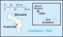
Map showing Bonaire, Sint Eustatius, and Saba
-
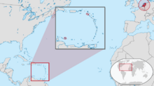
This map shows how far the Caribbean Netherlands is from the main part of the Netherlands in Europe.
-
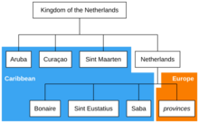
This chart shows that the Caribbean BES islands are parts of the country of the Netherlands.
-
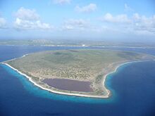
Klein Bonaire is a small island near Bonaire.
-
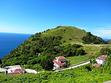
The island of Saba has many hills.

_in_the_Kingdom_of_the_Netherlands.svg)

.jpg)
.jpg)
Climate and Nature
The islands of the Caribbean Netherlands have a tropical climate. This means the weather is warm all year round. The Leeward Antilles (like Bonaire) are usually warmer and drier than the Windward islands (like Saba and Sint Eustatius). During the summer, the Windward Islands can sometimes experience hurricanes.
About 6% of the land in the Caribbean Netherlands is covered by forest. This is about 1,910 hectares (4,720 acres) of forest. This amount has not changed since 1990. In 2020, all of this forest was naturally growing. None of it was planted. About 17% of the forest area is found inside protected areas.
What Currency Do They Use?
Before January 1, 2011, the three islands used the Netherlands Antillean guilder. After that, they all started using the U.S. dollar. This is different from the euro, which is used in the European Netherlands. It is also different from the Caribbean guilder, which Curaçao and Sint Maarten are now using.
Communications and Internet
The telephone country code for these islands is 599. This code was used by the former Netherlands Antilles and is still shared with Curaçao. The International Organization for Standardization has given these islands the code ISO 3166-2:BQ. The IANA has not yet set up the .bq Internet ccTLD (country code top-level domain). It is not known if this internet address will be used in the future.
See also
 In Spanish: Caribe Neerlandés para niños
