Anegada Passage facts for kids
Quick facts for kids Anegada Passage |
|
|---|---|

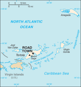
Map of the British Virgin Islands, with the Anegada Passage labeled at right side.
|
|
| Coordinates | 18°22′41″N 63°50′15″W / 18.37806°N 63.83750°W |
| Basin countries | British Virgin Islands Anguilla |
| Max. length | 200 kilometres (120 mi) |
| Max. width | 65 kilometres (40 mi) |
| Average depth | 2,300 metres (7,500 ft) |
The Anegada Passage is a special waterway in the Caribbean Sea. It acts like a big watery highway, separating the British Virgin Islands from Anguilla (specifically, Sombrero Island). This passage is super important because it connects the Caribbean Sea with the huge Atlantic Ocean. It's also very deep, going down about 2,300 meters (that's over 7,500 feet!).
Contents
What is the Anegada Passage?
The Anegada Passage is a type of strait. A strait is a narrow channel of water that connects two larger bodies of water. Think of it like a natural bridge made of water.
Where is it Located?
This passage is found in the eastern part of the Caribbean. It sits between the British Virgin Islands to the west and Sombrero Island (part of Anguilla) to the east. It's a key spot on maps of the Caribbean.
How Deep is the Passage?
The Anegada Passage is incredibly deep. At its deepest point, it plunges about 2,300 meters (or 7,546 feet) below the surface. This depth allows deep ocean water from the Atlantic to flow into parts of the Caribbean Sea.
Why is the Anegada Passage Important?
This waterway plays a big role in global shipping. It's like a busy road for ships.
A Key Shipping Lane
The Anegada Passage is a very important route for ships heading to or from the Panama Canal. The Panama Canal is a famous shortcut that connects the Atlantic and Pacific Oceans. So, many ships use the Anegada Passage to get to this canal.
A Challenge for Sailors
Sailors sometimes call this passage the "Oh-my-god-a Passage." This nickname tells you it can be a tough place to sail! The winds, waves, and ocean swells here can be very strong. This makes it a challenging journey for even experienced sailors.
What's Under the Water?
The Anegada Passage isn't just a flat, deep trench. It has many different features on its seafloor.
Basins and Ridges
Under the water, the passage has several deep areas called basins and raised areas called ridges. These are like underwater valleys and mountains. They make the seafloor very uneven.
The Anegada Trough
One important part is the Anegada Trough, also known as the Virgin Islands Basin. This deep underwater valley is famous for a historical event.
The 1867 Earthquake and Tsunami
The Anegada Trough was likely the spot where a big earthquake happened in 1867. This earthquake was very powerful. After the earthquake, a huge tsunami followed. A tsunami is a series of very large ocean waves caused by underwater disturbances, like earthquakes. This event caused significant changes to the seafloor in the area.
See Also
 | Aurelia Browder |
 | Nannie Helen Burroughs |
 | Michelle Alexander |


