Serranilla Bank facts for kids
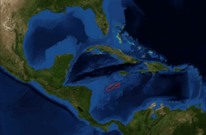
The Serranilla Bank is a special kind of atoll located in the southeastern Caribbean Sea. It's about 400 kilometers (250 miles) northeast of Nicaragua. An atoll is a ring-shaped coral reef, island, or group of islands that surrounds a lagoon.
Only the eastern and southern parts of this reef can be seen above the water. The bank is made up of several small sandy islands called cays. It measures about 45 kilometers (28 miles) long and 37 kilometers (23 miles) wide. The total area it covers is around 1,200 square kilometers (460 square miles). Many parts of the coral reef become dry when the tide is low. The ocean depth around most of the bank is between 9 meters (30 feet) and 37 meters (120 feet).
Contents
Exploring the Islands and Rocks of Serranilla Bank
The Serranilla Bank has several interesting features, including small islands and rock formations. Each one has its own unique characteristics.
Northeast Breaker: A Rocky Spot
Northeast Breaker is a formation of rocks. It is found about 2 kilometers (1.2 miles) from the eastern edge of the atoll.
East Cay: A Bushy Island
East Cay is a small island located about 5.5 kilometers (3.4 miles) west of the eastern edge. This island is mostly covered with bushes.
Beacon Cay: The Biggest Island
Beacon Cay is the largest island on the Serranilla Bank. It is about 14 kilometers (8.7 miles) southwest of East Cay. This island is sandy, but it also has some coral rock formations. Like East Cay, it is covered with bushes, and Grass grows in some areas.
There are between 30 and 50 coconut palms growing on Beacon Cay. At its western end, you can find a daymark made from corals. A daymark is a structure that helps ships navigate during the day. There are also some buildings on the island. An active lighthouse has been operating here since 1977. This lighthouse is made of steel and is likely managed by Colombian authorities.
Middle Cay: A Small Sandy Island
Middle Cay is another small island. It is made entirely of sand and is located about 3.5 kilometers (2.2 miles) west of East Cay.
West Breaker: A Hidden Danger
West Breaker is a rock formation found about 15 kilometers (9.3 miles) west of Beacon Cay. This rock formation can be dangerous for ships. It is only about 0.5 meters (1.6 feet) above the water's surface, sitting on a platform made of corals. In 1985, sailors reported that maps at the time were not accurate. They noted that these rocks actually extend another 3.5 kilometers (2.2 miles) further to the west.
See also
 In Spanish: Isla Serranilla para niños
 | Roy Wilkins |
 | John Lewis |
 | Linda Carol Brown |


