
Guatemala facts for kids
Quick facts for kids
Republic of Guatemala
República de Guatemala (Spanish)
|
|
|---|---|
|
Motto: Libre crezca fecundo (Spanish)
"Grow Free and Fecund" |
|
|
Anthem:
Himno Nacional de Guatemala ("National Anthem of Guatemala") |
|
|
March:
La Granadera ("The Song of the Grenadier") |
|
.svg) Location on the Western Hemisphere Location on the Western Hemisphere Guatemala and its neighbors Guatemala and its neighbors |
|
| Capital and largest city
|
Guatemala City 14°38′N 90°30′W / 14.633°N 90.500°W |
| Official languages | Spanish |
| Recognised national languages | Mayan |
| Recognised regional languages |
|
| Ethnic groups
(2018)
|
|
| Religion
(2017)
|
|
| Demonym(s) | Guatemalan Chapín Guatemalteco (M) Guatemalteca (F) |
| Government | Unitary presidential republic |
| Bernardo Arévalo | |
| Karin Herrera | |
|
• President of the Congress
|
Nery Ramos |
| Legislature | Congress of the Republic |
| Independence | |
|
• Declared
from the Spanish Empire |
15 September 1821 |
|
• Declared from the
First Mexican Empire |
1 July 1823 |
|
• Declared from the Federal Republic of Central America
|
17 April 1839 |
|
• Current constitution
|
31 May 1985 |
| Area | |
|
• Total
|
108,889 km2 (42,042 sq mi) (105th) |
|
• Water (%)
|
0.4 |
| Population | |
|
• 2023 estimate
|
17,980,803 (70th) |
|
• Density
|
166/km2 (429.9/sq mi) (80th) |
| GDP (PPP) | 2024 estimate |
|
• Total
|
|
|
• Per capita
|
|
| GDP (nominal) | 2024 estimate |
|
• Total
|
|
|
• Per capita
|
|
| Gini (2014) | 48.3 high |
| HDI (2022) | medium · 136th |
| Currency | Quetzal (GTQ) |
| Time zone | UTC−6 (CST) |
| Date format | dd/mm/yyyy |
| Driving side | right |
| Calling code | +502 |
| ISO 3166 code | GT |
| Internet TLD | .gt |


Guatemala is a country in Central America. It is famous for its unique culture. This culture mixes ancient Maya traditions with Spanish influences from long ago.
Guatemala's weather changes a lot because of its mountains. The country also has many languages, with 23 different ones spoken! Because it's so beautiful, many people love to visit Guatemala.
Guatemala City is the capital city. Guatemala is the world's largest producer and exporter of cardamom, a spice.
Contents
What Does the Name Guatemala Mean?
The name "Guatemala" comes from an old word, Cuauhtēmallān. This word means "place of many trees." It might also refer to a specific tree called Cuate/Cuatli. Warriors who came with Pedro de Alvarado during the Spanish conquest gave this name to the land.
People of Guatemala
Guatemala has the largest population in Central America. It shares borders with Belize, Mexico, El Salvador, and Honduras. Over 17 million people live in Guatemala's 22 regions.
Most people are mestizo, meaning they have mixed Native and European backgrounds. They make up about 56% of the population. Native Maya people are a large group too, making up about 42%. A smaller part of the population are direct descendants of people from Spain and Germany.
Guatemala's History

Ancient Maya Times
People have lived in Guatemala for a very long time, at least since 12,000 BC. Early settlers were hunters and gatherers. But by 3500 BC, they started growing maize (corn).
Archaeologists divide ancient Mesoamerican history into three periods:
- The Pre-Classic (2000 BC to 250 AD)
- The Classic (250 to 900 AD)
- The Post-Classic (900 to 1500 AD)
In the Pre-Classic period, people built huge structures. For example, the city of El Mirador was very large. It was the first politically organized state in America, called the Kan Kingdom. Its cities were connected by long, wide highways made of stucco.

The Classic period was the golden age of the Mayan civilization. Many cities were built, and independent city-states grew. This period ended around 900 AD. Many Maya cities in the lowlands were abandoned. Scientists think a long period of drought might have caused this collapse.
In the Post-Classic period, regional kingdoms like the Itzá and Ko'woj continued Maya culture. But these cities were not as big or powerful as the Classic ones.
Spanish Colonial Rule

Spanish explorers arrived in Guatemala starting in 1518. Soon after, a terrible sickness spread, which greatly harmed the native people.
Hernán Cortés, who conquered Mexico, allowed Pedro de Alvarado to conquer Guatemala. Alvarado first teamed up with the Cakchiquel people to fight their rivals, the Quiché. Later, Alvarado turned against the Cakchiquels and took control of the whole region for Spain.
During this time, Guatemala was a Spanish colony. It stretched from parts of modern Mexico all the way to Costa Rica. This area did not have as much gold and silver as Mexico or Peru. Its main products were sugarcane, cocoa, and dyes like añil and cochineal. They also exported precious woods.
The capital city moved several times. It was first called Tecpan Guatemala in 1524. It moved to Ciudad Vieja in 1527. Then, after a flood in 1541, it moved to Antigua Guatemala. This city was destroyed by earthquakes in 1773. So, the capital moved again to its current location, Guatemala City, in 1776.
Becoming an Independent Nation

On September 15, 1821, Guatemala and its neighbors declared independence from Spain. They joined the Mexican Empire, but this empire soon dissolved.
The Guatemalan provinces then formed the Federal Republic of Central America. This federation broke apart in a civil war from 1838 to 1840. Rafael Carrera was a key leader in this revolt. He led the country until 1865.
Later, in 1871, Justo Rufino Barrios led a "Liberal Revolution." He worked to modernize Guatemala and improve trade. During his time, coffee became a very important crop. Barrios wanted to reunite Central America, but he died in battle in 1885.
From 1944 to Today
In 1944, a leader named Jorge Ubico was overthrown. This started a ten-year period of big social and economic changes. But in 1954, a military coup, supported by the U.S., ended this revolution. A dictatorship was put in place.
From 1960 to 1996, Guatemala had a long and difficult Guatemalan Civil War. The government fought against rebel groups. During this time, many Maya people suffered greatly. A peace agreement was signed in 1996. Since then, Guatemala has seen economic growth and democratic elections. However, poverty and crime are still big challenges.
Guatemala's Geography

Guatemala is a mountainous country. It has small deserts and sand dunes, with many hilly valleys. The southern coast and the northern lowlands of Petén are flatter.
Two mountain chains cross Guatemala from west to east. They divide the country into three main regions:
- The highlands, where the mountains are.
- The Pacific coast, south of the mountains.
- The Petén region, north of the mountains.
Most major cities are in the highlands and on the Pacific coast. Petén is not as populated. These regions have different climates and landscapes. You can find hot, humid tropical lowlands and colder, drier mountain peaks. Volcán Tajumulco is the highest point in Central America, standing at 4,220 meters (13,845 feet).
Guatemala's rivers on the Pacific side are short and shallow. Rivers flowing into the Caribbean Sea and the Gulf of Mexico are larger and deeper. Important rivers include the Polochic, Dulce, Motagua River, Sarstún, and Usumacinta River.
Natural Disasters

Guatemala is located between the Caribbean Sea and the Pacific Ocean. This makes it a target for hurricanes. For example, Hurricane Mitch in 1998 and Hurricane Stan in 2005 caused a lot of damage. The damage was mostly from heavy flooding and mudslides, not just wind. Hurricane Eta in 2020 also caused many deaths and disappearances.
Guatemala's highlands are on the Motagua Fault. This is where the Caribbean Plate and North American Plate meet. This fault has caused several big earthquakes. A 7.5 magnitude earthquake in 1976 killed over 25,000 people.
The Middle America Trench is off the Pacific coast. Here, the Cocos Plate is sliding under the Caribbean Plate. This causes volcanic activity inland. Guatemala has 37 volcanoes, and four of them are active: Pacaya, Santiaguito, Fuego, and Tacaná.
Natural disasters have shaped Guatemala's history. For instance, the capital city had to move twice because of volcanic mudflows and earthquakes.
Amazing Biodiversity
Guatemala is home to 14 different ecoregions. These include mangrove forests and ocean coasts, with five different ecosystems. It has 252 wetlands, including lakes, lagoons, rivers, and swamps. Tikal National Park is a special UNESCO World Heritage Site.
Guatemala has a rich variety of animals. There are about 1,246 known species. Some of these animals are found only in Guatemala. Many are also threatened. The country also has at least 8,682 types of vascular plants. About 13.5% of these plants are found only in Guatemala.
The Maya Biosphere Reserve in the Petén region is huge. It covers over 2 million hectares. It is the second-largest forest in Central America.
Guatemala's Economy

.jpg)
Guatemala exports many things, including fruits, vegetables, flowers, and handicrafts. The country also grows and exports more raw materials for biofuels, like sugar cane and palm oil. Some people worry that growing these crops can make basic foods like corn more expensive. Guatemala imports almost half of its corn from the United States.
Guatemalan Culture
_(6941638140).jpg)
Guatemala City has many important libraries and museums. These include the National Archives and the National Library. The Museum of Archeology and Ethnology has a large collection of Maya artifacts. There are also private museums like the Ixchel Museum of Indigenous Textiles and Clothing and the Museo Popol Vuh. These museums focus on Maya archaeology. Most of Guatemala's towns also have a small museum.
Music in Guatemala

Guatemalan music has many styles. Music like nueva cancion has helped bring social change. It tells stories of history, current issues, and the struggles of everyday people.
The ancient Maya had a strong musical tradition. European music came to Guatemala early, starting in 1524. Many composers have created music in different styles over the centuries.
The marimba is Guatemala's national instrument. It has a large collection of popular and beautiful songs.
Delicious Cuisine
Many traditional Guatemalan foods come from Maya cuisine. They often use maize (corn), chilies, and black beans. Popular stews include Kak'ik (a tomato-based turkey stew), pepian, and cocido.
Guatemala is also known for its antojitos, which are small snacks. These include small tamales called chuchitos, fried plantains, and tostadas with tomato sauce, guacamole, or black beans.
Some foods are eaten on specific days. For example, paches (potato tamales) are often eaten on Thursdays. Certain dishes are also for special occasions. Fiambre is eaten on All Saints' Day (November 1st). Tamales and ponche (fruit punch) are very common around Christmas.
Related pages
- Fuego volcano
- Guatemala at the Olympics
- Guatemala national football team
- List of rivers of Guatemala
Images for kids
-
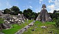
Maya city of Tikal
-
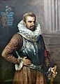
The Conquistador Pedro de Alvarado led the initial Spanish efforts to conquer Guatemala.
-
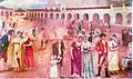
Criollos rejoice upon learning about the declaration of independence from Spain on 15 September 1821.
-
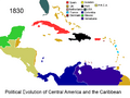
The Federal Republic of Central America (1823–1838) with its capital in Guatemala City.
-
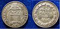
Proclamation Coin 1847 of the independent Republic of Guatemala
-
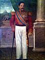
Captain General Rafael Carrera after being appointed president for Life in 1854.
-
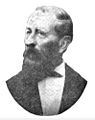
Vicente Cerna y Cerna was the president of Guatemala from 1865 to 1871.
-
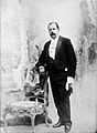
Manuel Estrada Cabrera ruled Guatemala between 1898 and 1920.
-
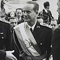
Guatemala's democratically elected president Jacobo Árbenz was overthrown in a coup planned by the CIA, The United Fruit Company had lobbied the U.S. to overthrow him.
-
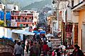
An outdoor market in Chichicastenango, 2009
-

Guatemala City is the capital and largest city of Guatemala and the most populous urban area in Central America.
-
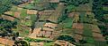
Fields in Quetzaltenango.
-
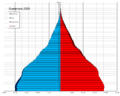
Population pyramid in 2020
-
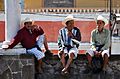
Tz'utujil men in Santiago Atitlán.
-
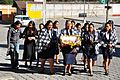
Indigenous Guatemalan women in Antigua Guatemala.
-
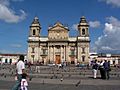
The Catedral Metropolitana, Guatemala City.
-
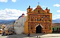
A church in San Andrés Xecul.
-
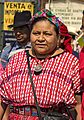
Author Rigoberta Menchú
-
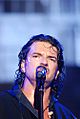
Famous singer Ricardo Arjona
-
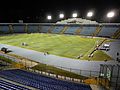
Estadio Doroteo Guamuch Flores in Guatemala City.

.jpg)


See also
 In Spanish: Guatemala para niños
