
Pacaya facts for kids
Quick facts for kids Pacaya |
|
|---|---|

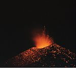
An eruption of Pacaya in 1976
|
|
| Highest point | |
| Elevation | 2,552 m (8,373 ft) |
| Prominence | 1,077 m (3,533 ft) |
| Listing | List of volcanoes in Guatemala |
| Geography | |

Pacaya
Location in Guatemala
|
|
| Geology | |
| Age of rock | 0-23,000 |
| Mountain type | Complex volcano |
| Volcanic arc/belt | Central America Volcanic Arc |
| Last eruption | February 14, 2021 - ongoing |
Pacaya is an active volcano in Guatemala. It first erupted about 23,000 years ago. Since the Spanish arrived, it has erupted at least 23 times!
Pacaya stands tall at 2,552 meters (8,373 feet). It was quiet for over 70 years, but then it started erupting strongly in 1961. Since then, it has been erupting often. Most of its eruptions are like a "fireworks show," with lava and ash shooting out (called Strombolian). Sometimes, there are bigger, more explosive eruptions (called Plinian), which can send ash far into nearby towns.
This volcano is a very popular place for tourists to visit. People even run a special race called the Guatemala Impact Marathon there. Runners cross a lava field that formed during the 2010 eruption. This race helps support the local communities. Pacaya is about 30 kilometers (19 miles) southwest of Guatemala City and close to Antigua. It is located in the Escuintla Department. You can even try "Volcano Boarding" on some of Pacaya's slopes!
In March 2021, Pacaya threw ash into the air. Even though people were asked to leave, some villagers living nearby chose to stay.
Contents
How Pacaya Formed
The Pacaya volcano is part of the Central America Volcanic Arc. This is a long line of volcanoes that stretches along the Pacific coast of Central America. These volcanoes formed because one giant tectonic plate (the Cocos Plate) is slowly sliding under another (the Caribbean Plate). This process is called subduction.
Pacaya sits on the edge of a very large caldera (a big bowl-shaped hollow formed after a volcano collapses). This caldera was created a long time ago and now holds Lago de Amatitlán, a lake. This area has had at least nine huge explosions over the last 300,000 years. These explosions released a lot of molten rock, about 70 cubic kilometers (17 cubic miles) of magma!
After the last big caldera-forming eruption 23,000 years ago, smaller volcanoes began to grow. Pacaya is the biggest of these newer volcanoes. It has been one of the most active volcanoes in Central America for the past 500 years. It has erupted at least 23 times since the Spanish conquest.
About 1,100 years ago, a large part of Pacaya's side collapsed. This caused a huge landslide that traveled about 25 kilometers (16 miles) all the way to the Pacific coast. This landslide left a big crater. The active cone you see today has grown inside this crater. Scientists know there is still a magma chamber (a pool of molten rock) close to the surface under Pacaya. This means that the volcano could become unstable again, and future landslides are a risk to the surrounding areas.
Visiting Pacaya Volcano

Because Pacaya is almost always active, it's a very popular spot for tourists. It's easy to get to from Guatemala City and Antigua. Pacaya and the area around it are now part of the Pacaya National Park. This park helps manage tourism and protect the region. The park earns money from tour groups, who pay a small fee to enter.
Recent Eruptions and Events
In 1998, Pacaya had several explosive eruptions. These eruptions sent out lava, rocks, and ash clouds that reached heights of 1,500 to 5,000 meters (4,900 to 16,400 feet). Ash fell on nearby cities, including Guatemala City and La Aurora International Airport.
In 2006, Pacaya's activity increased a bit. This led to several rivers of lava slowly flowing down its slopes. When people heard about this, many more tourists came to see the lava flows.
May 2010 Eruption
On May 27, 2010, the Pacaya volcano erupted strongly. This was followed by several tremors. Around 8:00 PM, there was a powerful eruption that shot out rocks and ash clouds up to 1,500 meters (4,900 feet) high. Ash rained down on many cities northwest of the volcano, including Guatemala City. The ash even covered La Aurora, the international airport.
The National Coordinator for Disaster Reduction (CONRED) told people in communities near the volcano to leave their homes. Sadly, a reporter named Anibal Archila, who was covering the event, was reportedly killed by volcanic debris.
The President of Guatemala, Álvaro Colom, declared a state of emergency in the area around the volcano. The Ministry of Education closed schools in the departments of Guatemala, Escuintla, and Sacatepequez. Heavy rain from Tropical Storm Agatha made the situation worse. It caused lahars (mudflows), landslides, and widespread flooding across the country. However, coffee farmers found the rain helpful because it washed the ash off their coffee trees.
See also
 In Spanish: Volcán de Pacaya para niños
Images for kids
- Pacaya
-
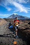
Runners at the Impact Marathon race on Pacaya
-
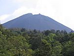
Volcán Pacaya (2005).
-
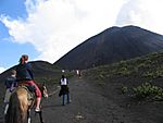
Tourists climbing Pacaya (2004).
-
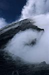
Noxious gas cloud (2002).
-
Pacaya after a strombolian eruption (1992).
-
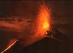
Strombolian eruption of Pacaya (1992).
-
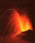
Strombolian eruption of Pacaya (1992).
-
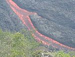
Lava flow (2006).


