
Usumacinta River facts for kids
Quick facts for kids Usumacinta River |
|
|---|---|

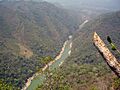
Usumacinta Canyon, Tenosique, Tabasco
|
|

Location of mouth
|
|
| Native name | Río Usumacinta (Spanish) |
| Countries | Guatemala and Mexico |
| State | Tabasco, Chiapas |
| Municipality | Tenosique, Balancán, Emiliano Zapata, Jonuta and Centla |
| Physical characteristics | |
| Main source | Confluence of Chixoy River and Pasión River Esperanza, Petén Department, Guatemala 16°00′00″N 90°32′35″W / 16°N 90.542942°W |
| River mouth | Gulf of Mexico 0 m (0 ft) 18°38′58.20″N 92°28′4.0″W / 18.6495000°N 92.467778°W |
| Length | 1,000 km (620 mi) |
| Basin features | |
| Tributaries |
|


The Usumacinta River is a very important river in southeastern Mexico and northwestern Guatemala. Its name comes from the howler monkey. This long river forms where two other rivers meet: the Pasión River and the Salinas River. The Pasión River starts in the mountains of Guatemala, and the Salinas River (also called the Chixoy River) comes down from the Sierra Madre de Chiapas mountains.
The Usumacinta River forms part of the border between Guatemala and the Mexican state of Chiapas. Then, it flows through the Mexican state of Tabasco. Finally, it empties into the Gulf of Mexico.
After being a border river, the Usumacinta enters Mexico fully in Tabasco. Here, it flows through the Cañón del Usumacinta (Usumacinta Canyon). This area has amazing canyons. After passing a part of the canyon called "Boca del Cerro" near Tenosique, the river spreads out into the flat lands of Tabasco.
The Usumacinta River has smaller rivers that branch off from it. These are called distributaries. The Palizada River and San Pedro y San Pablo River are two such branches. They flow into the Laguna de Términos, a large lagoon. In Tabasco, the Grijalva River also flows into the Usumacinta. This meeting point is called Tres Brazos, in Centla.
When these rivers join, they create a huge wetland area. This area is known as the Pantanos de Centla. These wetlands are a special protected area called a biosphere reserve. They cover a massive 302,702 hectares (747,990 acres) of land. This makes them the largest protected wetlands in North and Central America. They are also one of the top 15 largest wetlands in the world.
The Usumacinta River, including its source rivers in Guatemala, is about 1,000 kilometres (620 mi) long. It is a natural boundary that separates the Yucatán Peninsula from the rest of Mexico.
Contents
What is the History of the Usumacinta River?
The Usumacinta River and its smaller rivers were once very important. They served as trade routes for the ancient Maya civilization. Two powerful Maya cities, Yaxchilan and Piedras Negras, were built right along its banks.
How Did People Travel Along the River?
Before modern roads were built, the river was the only way to travel in this jungle region. For example, the Border Highway was built in the early 1990s. Before that, people used the river. Large logs from hardwood trees were floated down the river to the state of Tabasco.
What About People Seeking Safety?
In the 1980s, many people from Guatemala sought safety. They crossed the river into Mexico to escape difficult situations. Other groups of people and Guatemalan freedom fighters lived in communities in the jungle. They stayed hidden from the government until peace agreements were made in the 1990s.
Efforts to Protect the River and Land
In the 1950s, two explorers named Frans and Trudi Blom had an idea. They wanted to protect a part of the jungle called Selva Lacandona. They also wanted to protect the Lacandon Maya who lived there. Their idea was to save both the culture and the natural environment. This idea is still important today. It shows that the well-being of local people and nature are connected. Many people working to protect this area agree with this idea.
Plans for a Dam and Public Awareness
In the 1980s, there was a plan to build a very large hydroelectric dam on the Usumacinta River. This dam would have been built at "Boca del Cerro" in Tenosique, Tabasco. It would have flooded many areas, including ancient Maya sites like Piedras Negras and Yaxchilan.
At that time, parts of the Guatemalan side of the river were controlled by freedom fighters. Their presence made it harder for people to illegally cut down trees, hunt animals, or steal artifacts. It also made it harder for dam engineers to work.
In 1985, an article by Jefferey Wilkerson in National Geographic magazine brought the river to public attention. People learned about its beauty and importance. Other writers also wrote about the river and its history. In the end, the dam project did not happen. There were many reasons, like problems with the land and distance from cities. But the strong protests from people who cared about nature, history, and the public also helped stop it. This event set a pattern for future conservation efforts.
Tourism and Later Challenges
After the National Geographic article, a popular seasonal tourism business started. People loved to travel on the river. It became a favorite spot for river adventurers, people interested in Maya history, bird watchers, and wildlife lovers. This tourism helped bring attention and support for protecting the area.
In 1990, another plan for a smaller dam was suggested. However, articles in The New York Times and ideas from Homero Aridjis for a shared protected area between Mexico and Guatemala helped stop this plan too.
In the late 1990s, scientists and organizations met to study the region. They wanted to map out the different types of natural habitats. This meeting helped answer important questions about how to manage and protect the area.
Later, events like the Zapatista Rebellion in 1994 and 1995, and peace agreements in Guatemala in 1996, changed the political situation. Sadly, due to safety concerns, river trips for tourists stopped. This was a loss because tourism could have helped with conservation and protecting ancient sites.
See also
 In Spanish: Río Usumacinta para niños
- List of longest rivers of Mexico
Images for kids
-
Usumacinta Canyon, Tenosique, Tabasco
-
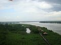
In "Tres Brazos" the Usumacinta joins to San Pedrito river and Grijalva river, in the Wetlands of Centla, biosphere reserve, in Tabasco.
-
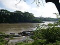
The Usumacinta River. One bank is Guatemala; the other is Mexico. Photograph taken from the Mexican side.
