
Chiapas facts for kids
Quick facts for kids
Chiapas
|
|||
|---|---|---|---|
|
|||

Location within Mexico
|
|||
| Country | |||
| Capital | Tuxtla Gutiérrez | ||
| Municipalities | 118 | ||
| Largest City | Tuxtla Gutiérrez | ||
| Area
Ranked 8th |
|||
| • Total | 74,211 km2 (28,653 sq mi) | ||
| Population
(2005)
|
|||
| • Total | 4,293,459(Ranked 7th) | ||
| HDI (2004) | 0.7076 - medium Ranked 32nd |
||
| ISO 3166-2 | MX-CHP | ||
| Postal abbr. | Chis. | ||
| Website | Chiapas State Government | ||


Chiapas is the southernmost state in Mexico. It is located in the southeast part of the country. Chiapas shares borders with the states of Tabasco to the north, Veracruz to the northwest, and Oaxaca to the west. To the east, Chiapas borders Guatemala, and to the south, it meets the Pacific Ocean.
Chiapas covers an area of about 28,528 square miles (73,890 km2). In 2005, the population was 4,293,459 people.
Contents
Climate and Nature in Chiapas
Chiapas generally has a humid, tropical climate. In the northern part, near the border with Tabasco, especially around Teapa, there can be more than 3,000 mm (118 in) of rain each year. This area used to have tall, green rainforests. However, most of these forests have been cleared for farms and ranches.
As you move towards the Pacific Ocean, the rainfall decreases. Still, there is enough rain to grow crops like bananas and other tropical plants near Tapachula. In the mountain ranges that run through the center of Chiapas, the climate is cooler and often foggy. This allows for cloud forests to grow, like those in the Reserva de la Biosfera el Triunfo. These forests are home to rare birds such as quetzals and horned guans.
Cities and Ancient Sites
The state capital of Chiapas is Tuxtla Gutiérrez. Other important cities and towns include San Cristóbal de las Casas, Comitán, and Tapachula.
Chiapas is also famous for its ancient Maya ruins. These include amazing sites like Palenque, Yaxchilan, Bonampak, Chinkultic, and Tonina. These places show the rich history of the Maya people.
People and Challenges
Many people in Chiapas are small farmers living in rural areas. About one-quarter of the population are of Maya descent. In many rural areas, people speak Maya languages and do not speak Spanish.
Chiapas faces some challenges. It has the highest rate of malnutrition in Mexico, affecting over 40% of the people. There are also issues related to migration, as many people from Central America pass through Chiapas on their way to the United States. This can sometimes make local poverty worse.
The Zapatista Movement
In 1994, there was a conflict between the Mexican Government and a group called the Zapatista Army of National Liberation (EZLN), also known as the Zapatistas. This group was named after Emiliano Zapata, a famous Mexican revolutionary.
Today, the EZLN has stopped using force. They now work to be a voice for the poor people in Chiapas. They control 32 "rebel autonomous zapatista municipalities," which are independent Zapatista communities. Examples of these communities are Ocosingo and Las Margaritas.
Images for kids
-
Jaguar sculpture from Cintalapa (1000-400 BCE) at the Regional Museum of Anthropology and History of Chiapas.
-
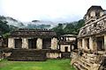
The Palace at Palenque, an ancient Maya city.
-
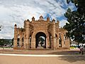
The Royal Crown fountain in the main plaza of Chiapa de Corzo, built in 1562.
-

Remnants of frescos at the Saint Mark Cathedral of Tuxtla Gutiérrez.
-
Comitán's declaration of independence from 1823.
-
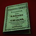
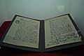
A copy of the 1825 state constitution.
-
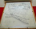
An 1856 map of the state of Chiapas.
-
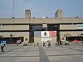
The Palace of Government of Chiapas (Governor's Office) at Tuxtla Gutiérrez.
-
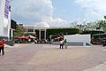
The Legislative Palace at Tuxtla Gutiérrez.
-
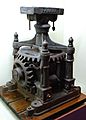
A sugar cane mill from Tapachula, on display at the Regional Museum in Chiapas.
-
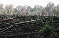
An area of the Lacandon Jungle burned to plant crops.
-
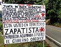
A sign marking Zapatistas Territory in Chiapas.
-
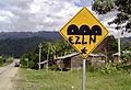
Graffiti by the Zapatista Army of National Liberation (EZLN) in Chiapas.
-
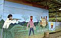
An EZLN mural in Chiapas, depicting a story in Spanish and Mayan.
-
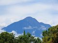
Mount Tacaná, a volcano.
-
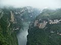
A view of the Sumidero Canyon from above.
-
A lake at the Parque Nacional Lagunas de Montebello.
-
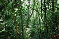
Jungle area near Group C at the Palenque archeological site.
-
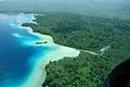
Miramar Lake, surrounded by the Lacandon Jungle.
-
A view of the Sierra Madre de Chiapas from the Soconusco Region.
-
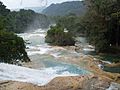
A view of the waterfalls at Agua Azul.
-
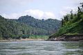
The Usumacinta River and Lacandon Jungle on the Chiapas side.
-
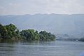
The Grijalva River flowing through the central region of Chiapas.
-
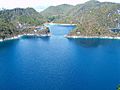
An overlook of part of the Malpaso or Nezahualcoyotl Reservoir.
-
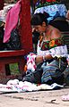
A Tzeltal woman in Palenque.
-
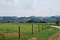
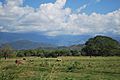
A ranch near Palenque.
-
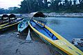
Boats at the docks of Frontera Corozal, serving the nearby Yaxchilan archeological site.
-
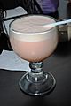
A traditional drink called taxcalate.
-
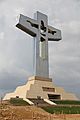
The Cristo de Chiapas, a large cross in Tuxtla Gutiérrez, built in 2011.
-
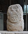
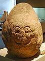
An Olmec-style stone sculpture from Tiltepec, at the Regional Museum of Chiapas.
-
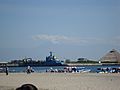
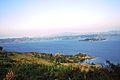
A view of Port Chiapas.


_graffiti_in_Chiapas,_Mexico.jpg)


.jpg)


See also
 In Spanish: Chiapas para niños
