Sumidero Canyon facts for kids
Quick facts for kids Cañón del Sumidero National Park |
|
|---|---|
| Parque Nacional Cañón del Sumidero | |
|
IUCN Category II (National Park)
|
|
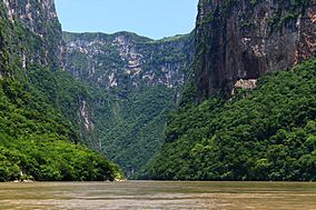
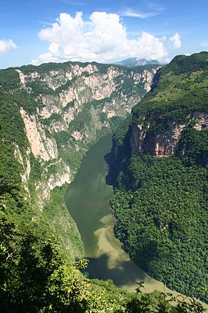
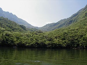
View of Sumidero Canyon, which is represented on the Chiapas state seal
|
|
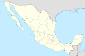
| Location | Chiapas, Mexico |
| Nearest city | Tuxtla Gutiérrez, Chiapas |
| Area | 21,789 ha (84.13 sq mi) |
| Established | December 8, 1980 |
| Governing body | Comisión Nacional de Areas Naturales Protegidas and Secretaría de Educación Pública |
| Official name: Parque Nacional Cañón del Sumidero | |
| Designated: | 2 February 2004 |
| Reference #: | 1344 |
The Sumidero Canyon (in Spanish: Cañón del Sumidero) is a huge natural canyon in southern Mexico. It's located just north of the city of Chiapa de Corzo in the state of Chiapas. This amazing canyon started forming around the same time as the famous Grand Canyon in the U.S. It was created by a crack in the Earth's crust. Then, the Grijalva River slowly carved it out over millions of years. This river still flows through the canyon today.
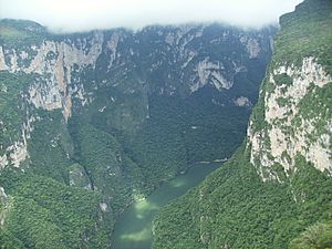
The Sumidero Canyon has very tall, straight walls. Some of these walls reach as high as 1,000 meters (about 3,280 feet). The river inside the canyon makes sharp turns, sometimes up to 90 degrees. This narrow passage is about 13 kilometers (8 miles) long.
The canyon is part of the Sumidero Canyon National Park. This park is a special protected area in Mexico. It covers a huge space of 21,789 hectares (about 53,842 acres). The park spreads across four different towns in Chiapas. The National Commission of Protected Natural Areas (CONANP) manages this park. Most of the plants in the park are from a type of rainforest where trees lose their leaves. There are also smaller areas with pine and oak trees, and some grasslands. At the northern end of the canyon, you'll find the Chicoasén Dam. This dam creates a large lake and is important for storing water. It also helps make electricity for the region.
The canyon and national park are very popular for tourists in Chiapas. Most visitors are from Mexico. They often explore the canyon by taking boat rides on the river from Chiapa de Corzo. The park is close to Tuxtla Gutiérrez, the biggest city in the state. This closeness has caused some problems. People have built homes and moved into parts of the park illegally. Also, cities and logging businesses upstream from the canyon cause a lot of pollution. Up to 5,000 tons of trash are pulled from the Grijalva River every year. This trash often gets stuck in the narrow canyon, especially near the Chicoasén Dam.
Contents
What is Sumidero Canyon?
How the Canyon Formed
The Sumidero Canyon was created by cracks in the Earth's crust. The Grijalva River then carved it out over a very long time. This process began about 35 million years ago. This means Sumidero Canyon is as old as the Grand Canyon in the U.S. The Grijalva River is the main waterway here. It starts in Guatemala and flows through Chiapas. It goes through the 13-kilometer (8-mile) canyon from south to north. Then it continues to Tabasco before joining the Usumacinta River. This river system is one of the most important in Mexico.
Besides the Grijalva, other streams flow into the canyon. Many of these streams are active only during the rainy season. Some form beautiful waterfalls on the canyon walls. There are also underground water flows that have created caves and unique rock formations. The Chicoasén Dam also created a large lake, which is another important water feature.
The canyon itself is very deep and narrow. It has tall, straight walls. The canyon changes direction sharply in some places. It separates two flat-topped mountains called mesas. The canyon's width changes from 1 to 2 kilometers (0.6 to 1.2 miles). Most of the walls are between 200 and 700 meters (650 to 2,300 feet) high. The highest points reach 1,000 meters (3,280 feet). These walls show layers of limestone rock. These rocks contain fossils of ancient sea creatures. This tells us that the area was once covered by an ocean.
Special Places in the Canyon
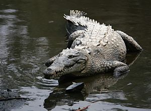
Inside the canyon, there are many interesting spots. You can find thirty rapids, five waterfalls, and three beaches. There are also two freshwater springs. The canyon is home to rare animals. These include the Central American river turtle and the American crocodile. You might spot them resting on the riverbanks.
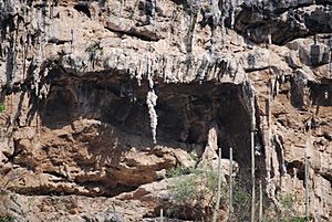
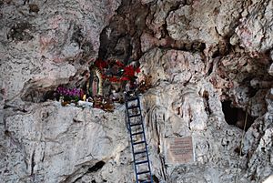
The canyon walls have many small caves and unique rock shapes. One famous cave is the Cueva de Colores ("Cave of Colors"). It gets its name from minerals that filter through the rock. These minerals create colorful streaks on the walls, especially pink shades. Inside, there's a statue of the Virgin of Guadalupe. Visitors often leave fresh flowers and burning candles around it.
Another cave is the Cueva de Silencio ("Cave of Silence"). It's called this because there's no echo inside. In another small cave, there's a stalactite that looks like a seahorse. It's called Caballito de Mar.
Of the seasonal waterfalls, the Árbol de Navidad ("Christmas Tree") is the most famous. Its "branches" are formed by mineral deposits covered in moss. During the rainy season, when the waterfall is active, the water and light make the "branches" stand out. The park was even considered as one of the Seven New Natural Wonders of the World in 2009.
Weather in the Park
The park is in the Central Valley of Chiapas. It also borders the Northern Mountains. This means the land goes from about 600 meters (1,970 feet) above sea level to 1,200 meters (3,940 feet) at some lookout points. This varied land creates different weather patterns.
The park has three main climates: hot and dry, semi-hot and humid, and hot and humid. The average rainfall is about 1,000 mm (39 inches) during the rainy season. This season runs from May to October. In the dry season, from November to April, it gets about 200 mm (8 inches) of rain. The average yearly temperature is 26°C (79°F). The rough land also creates many small, unique climates.
Plants of the Canyon
Most of the plants in the park are dense tropical rainforest. This is especially true around the canyon. The most common plant families are Fabaceae (peas and beans) and Asteraceae (daisies). Other important families include orchids and euphorbias. Many of these plants are valuable. Some are used as ornamental plants, others for medicine, and some for wood.
Most of the rainforest trees lose their leaves in the dry season. However, some parts have trees that stay green all year. There are also pine and oak forests, grasslands, and areas with new plant growth.
The main types of plants are:
- Medium-height deciduous rainforest: This is found on both sides of the canyon. Trees here can grow up to 25 to 30 meters (82 to 98 feet) tall. Many of these trees lose their leaves in the dry season.
- Low-height deciduous rainforest: This is found in the southern and southeastern parts of the park. Trees here are shorter, from 4 to 15 meters (13 to 49 feet) tall. This area has many succulent plants like Agave and Opuntia (prickly pear cactus).
- Pine-oak forests: These are found in the highest parts of the park, in the northwest. The most common tree is the oak Quercus acutifolia. Air plants, like bromeliads and orchids, are also common here.
- Grassland: These areas are not natural. They exist because of human activities like farming and raising animals. They are found on the north and south sides of the canyon.
Unfortunately, a lot of the park's forests have been damaged. This is mostly due to illegal logging and clearing land for farms or pastures.
Animals of the Canyon
Over time, human activities have greatly affected the park's wildlife. Things like new settlements, farming, and hunting have reduced the number of animals. However, since the park was created in the 1980s, animal diversity has increased.
In 1986, a study found 90 types of animals with backbones. This included fish, amphibians, reptiles, birds, and mammals. By 2005, another study found 308 species! This shows that the park's efforts to protect animals are working.
- Fish: There isn't much information about fish, but at least four protected species have been found.
- Reptiles: A 2007 study found 12 protected reptile species. This includes the river crocodile (Crocodylus acutus).
- Birds: Birds are the most common animals in the park, with about 195 species. Six of these are threatened, and 17 need special protection. One threatened bird is the great curassow. Many birds like the spotted sandpiper and black-bellied whistling duck live near the water.
- Mammals: Recently, 53 mammal species have been found. Two are threatened, two are in danger, and two need special protection. Endangered mammals include the spider monkey, jaguarundi, ocelot, lowland paca, white-tailed deer, and anteater. The most common mammals are a type of bat and a type of rat.
Sumidero Canyon National Park
Why the Park Was Created
The Sumidero Canyon area first became an ecological reserve in 1972. This was done by the state of Chiapas to protect its geology, history, and wildlife. It also allowed for scientific study. In 1980, the Mexican government took over and made it a larger national park. It grew to 21,789 hectares (about 53,842 acres). Most landowners were paid for their land, but not all people or businesses were moved out.
Since then, different government groups have managed the park. Today, the Comisión Nacional de Áreas Naturales Protegidas (CONANP) and the Secretaría de Educación Pública are in charge. In 2004, the park gained special protection under the Ramsar Convention. This is because of its important water systems and environment. The park was also recognized as a "Priority Terrestrial Region" and an "Important Bird Area" in 2000. In 2005 and 2006, the park grew even more. More land was added from nearby towns, making it 1,660 hectares (4,100 acres) larger. However, it is still smaller than most other national parks in Mexico.
The heart of the park is the Sumidero Canyon and the Grijalva River. The park's southern border on the river is the Belisario Domínguez Bridge. The northern border is the Chicoasén Dam, about 35 kilometers (22 miles) away. The rest of the park extends into the towns of Tuxtla Gutiérrez, Chiapa de Corzo, Osumacinta, and San Fernando. The park is open every day of the year.
The park has several sections:
- Northwest: Has medium-height rainforest and grasslands.
- Western: Similar plants to the northwest.
- Eastern: Has pine forests, rainforest, and grasslands.
- Southeast: Contains most of the canyon walls and the part of the river where boats can go.
You can enter the park by land from Tuxtla Gutiérrez. Another way is by boat from the Cahuaré Docks in Chiapa de Corzo. Since the canyon is the main attraction, several lookout points have been built along its edge. La Ceiba is the closest lookout to Tuxtla Gutiérrez, only 8.5 kilometers (5.3 miles) away.
Challenges for the Park
Protecting the Environment
The biggest challenge for Sumidero Canyon National Park is the pollution in the Grijalva River. Other threats include people building homes illegally and other human activities. About 1,500 to 2,000 hectares (3,700 to 4,900 acres) of the park have been taken over. This is mostly by illegal settlements near Tuxtla Gutiérrez. It's estimated that about 15,000 people live inside the park's borders. Many of these illegal homes are built by very poor people who have moved to the city. This has led to illegal land sales.
The rapid growth of Tuxtla Gutiérrez and Chiapa de Corzo has caused these problems. This growth has led to arguments over land ownership, loss of animal homes, and cutting down trees. In 2002, the government agreed to remove illegal settlements. They also work to stop new ones from forming. Some people have been moved out, and new settlements have been prevented. However, the problem is so big that some reports suggest that part of the park near the city might need to be changed. Also, there are still arguments about the exact park borders. Despite these issues, many parts of the park are still well-preserved, especially in areas with very rough land.
Besides illegal settlements, there are also legal activities that affect the park. Eight farming communities (called ejidos) border the park. Their activities directly impact it. Five ejidos and three settlements were established inside the park before it was created. As of 2005, 1,927 people lived within the park's borders. Because of human activity, this park is very likely to have wildfires. It was one of the most damaged parks by fires in Mexico from 2009 to 2011. Many fires start from human activities near the park.
There are also lime and other mining operations inside the park. These are legal because they were there before the park was established. However, these operations have destroyed about 2,600 hectares (6,400 acres) of land. They create noise, smoke, dust, and small tremors from explosions. Runoff from mining waste also pollutes the Grijalva River. The dust and smoke have even left a white coating on nearby plants.
River Pollution Problems
The Grijalva River carries wastewater from about 552,000 people through the Sumidero Canyon. Most of this comes from Tuxtla Gutiérrez, Chiapa de Corzo, Berriozábal, and Chicoasén. A lot of the sewage enters the Grijalva from the Sabinal River, which carries most of Tuxtla Gutiérrez's wastewater. Trash and raw sewage also flow into the river from smaller streams. Farms along the river add agricultural waste.
The most obvious pollution is garbage, especially plastic bottles. This trash mostly comes from homes and businesses that throw it on the ground or into streams. This happens because people lack environmental awareness. The amount of trash is highest during the rainy season. This is when rainwater and swollen streams carry more waste into the Grijalva. While plastic is easy to see, other signs of pollution include too many water lilies (from high levels of sewage) and dead animals.
However, plastic only makes up about five percent of the total waste. Most of the solid waste (80-90%) is branches, wood, rocks, and dirt from legal and illegal logging. This causes deforestation. This debris mostly enters the river during the rainy season. Only a small part of the solid waste is visible on the surface. Most of it is hidden underwater.
As the solid waste flows down the Grijalva, it gets squeezed by the narrow canyon. Then, it's blocked by the Chicoasén Dam. This is especially true at a spot called "El Tapón" (The Plug). Here, two water currents meet just before the dam's lake.
It's estimated that about 5,000 tons of trash build up each year. The Grijalva River is considered one of the five most polluted rivers in Mexico. In 2010 alone, 3,700 tons of solid waste were removed from the canyon area. Many fish have died or grown abnormally due to pollution from fertilizers and pesticides. This also harms the native American crocodiles, as the chemicals kill their food. In 2011, an international swimming group canceled its marathon in the canyon. They said the pollution levels were too risky for swimmers. However, local authorities disagreed, showing their own test results.
There are ongoing efforts to clean the river. Workers from CONANP and the Chiapas Tourism Secretariat remove 12 tons of garbage from the Grijalva river every day. Larger cleanups happen during the rainy season, especially in September and October. These efforts involve police, civil protection, social groups, the army, and volunteers. Up to 600 people can work at a time, using 32 boats. In 2005, over 60,000 tons of trash were removed during an annual campaign. Generally, about 40 tons of garbage are collected daily during these campaigns.
While cleanups help, the garbage builds up again, especially in the rainy season. Part of the money tourists pay for boat rides helps with cleanup. But boat operators say the canyon still has a lot of trash. CONANP also says cleanup efforts are not enough. Mexico's environmental agency says it's the local towns' job to dispose of trash properly. However, many of these towns don't have proper landfills or recycling programs.
Visiting Sumidero Canyon
What to Do and See
The beautiful scenery of the canyon has made it a major tourist spot. There are activities for ecotourism and extreme sports. The part of the Grijalva River where boats can go is mainly used for tours. The park has six lookout points that you can reach by land. These are La Ceiba, La Coyota, El Roblar, Tepehuaje, Los Chiapas, and Manos.
During the rainy season, the waterfalls are active and add to the beauty. These include the Árbol de Navidad, Cueva del Hombre, Cueva del Silencio, Cueva de Colón, Cueva de Colores, and Cueva del Suspiro. A lesser-known attraction is the Ruins of Berlin, an archaeological site.
The most important economic activity in the canyon is ecotourism. Most visitors are from Mexico. Weekends are the busiest. Local and regional visitors come to bike, swim, hike, camp, and picnic.
The canyon is the second most visited place in Chiapas, after Palenque. About 300,000 people visit the park each year. Around 80% are from Mexico, and the rest are from other countries. During holidays, between 1,000 and 7,000 people might visit each day. They either drive to the lookout points or take a boat from Chiapa de Corzo. The fees for entry and boat rides help pay for cleanup efforts.
Businesses in the park mostly serve tourists. They sell food and Mexican handcrafts and folk art. Tour boat operators work together in groups. Food and craft sellers work on their own. These businesses need a yearly permit to operate in the park.
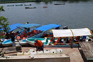
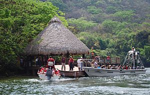
The most important businesses are the boats that take people through the canyon. Most boat tours start from Chiapa de Corzo. They travel about 30 kilometers (19 miles) along the river to the Chicoasén Dam. Chiapa de Corzo has two main docks for these boats. The largest is called Cahuare, with paved areas and a restaurant. The smaller one also has restaurants and a swimming area. These two docks host six tour groups. They have about 120 boats that can hold 10 to 40 passengers each. As they take visitors through the canyon, they share information about the environment, history, and culture.
There were some boat accidents from late 2009 to early 2010. Six tourists died, and 62 were hurt. The accidents happened on old boats. Many were operating without permission or with underage crew members. There were no ambulance boats or first aid services on shore. Two tour groups were suspended and fined. These accidents caused problems for tourism.
If you visit the canyon from the lookout points above, you'll find restaurants and other food places. There are also camping and picnic areas.
Other attractions include general ecotourism and extreme sports. The park has hiking trails. Fishing is sometimes allowed with a permit. You can also rent kayaks and other boats.
The Amikúu Ecological Park is inside the canyon area. You can reach it by boat from Chiapa de Corzo. This park has three parts:
- Discover the Canyon: Shows the canyon's history and how it formed. It also has a souvenir shop.
- Colors of Chiapas: A small museum showing traditional clothes and musical instruments of local people.
- Area of Adventure: Takes visitors on a tour of the rainforest. It has a suspension bridge, a reptile house, a bird enclosure, and areas for jaguars and crocodiles.
Extreme sports in the park include mountain biking, rappelling (climbing down ropes), spelunking (cave exploring), and more. Rappelling allows access to small caves that are otherwise unreachable. The dam area offers recreational fishing, with an annual tournament. One big yearly event is the Copa Mundo Fino swimming marathon. In 2006, an Australian base jumper died after jumping from an 800-meter (2,600-foot) cliff in the canyon. This happened during a sanctioned event with jumpers from different countries.
Chicoasén Dam
At the northern end of the Sumidero Canyon is the Chicoasén Dam. Its official name is the Manuel M. Torres Dam. It's one of several dams built on the Grijalva River. These dams store water and create hydroelectric power (electricity from water). This dam and its lake are considered part of the Sumidero Canyon system. The Sumidero Canyon National Park's northern river border is this dam. The southern border is the Belisario Domínguez Bridge. The dam was built between 1974 and 1980. The lake covers about 2,193 hectares (5,420 acres). About 600 people work at the dam complex.
The Chicoasén Dam makes electricity. It also controls the flow of the Grijalva River and other nearby streams. This lake is one of the most important in Mexico. The hydroelectric power station is also one of the most important in the country. It has thirty generators that can produce a lot of electricity. This dam alone produces over 30% of all hydroelectric energy in Mexico.
History of the Area
The history of this area is linked to the Chiapa people. They lived in the Central Valley before the Spanish arrived. We don't know exactly where they came from. Their main town was Chiapa de Corzo, near the canyon. They had a strong, fortified area in the higher parts of the canyon. This helped protect them from invaders.
The Chiapa people fought hard against the Spanish conquerors. They were not defeated until Diego de Mazariegos arrived in 1528. Their last stand was in the fortified area, now known as the Ruins of Berlin. The last of the Chiapa people held out there from 1528 to 1535. After that, the canyon became a border between the Zoque and Tzotzil peoples.
Until the 20th century, the canyon area was mostly unexplored. In 1895, three Frenchmen tried to explore it but drowned. An American also died trying in 1932. This led to stories about witchcraft and fierce crocodiles in the area. In 1960, a group of Mexican army soldiers, called the "red handkerchiefs," successfully traveled over 20 kilometers (12 miles) through the canyon by boat. This opened up the canyon for local exploration and tourism.
Not much archaeological work has been done in the area. The main site is called the Ruins of Berlin. It's named after German explorer Heinrich Berlin, who visited in 1946. This site is 7 kilometers (4.3 miles) from the Belisario Domínguez Bridge. It covers an area of 467 by 60 meters (1,532 by 197 feet). It has small mounds around open areas. Early descriptions called it Chiapa Viejo and said it was the capital of the Chiapa people. However, later studies suggested it was a smaller site. The last major survey was in 1976. It found 24 individual sites, including mounds and caves. One cave has paintings that show the area has been lived in since ancient times.
|
See also
 In Spanish: Cañón del Sumidero para niños
 | Kyle Baker |
 | Joseph Yoakum |
 | Laura Wheeler Waring |
 | Henry Ossawa Tanner |


