
Grijalva River facts for kids
Quick facts for kids Grijalva River |
|
|---|---|

The cliffs at Sumidero Canyon overlook the Grijalva River
|
|

Location of Grijalva in Mexico
|
|
| Native name | Río Grijalva (Spanish) |
| Country | Mexico |
| Physical characteristics | |
| River mouth | Gulf of Mexico 0 m (0 ft) 18°36′10″N 92°41′33″W / 18.60278°N 92.69250°W |
| Length | 480 km (300 mi) |
| Basin features | |
| Basin size | 134,400 km2 (51,900 sq mi) |
The Grijalva River is a long and important river in southeastern Mexico. It stretches for about 480 km (300 mi) (298 miles). People sometimes call it the Tabasco River, or Río Grande de Chiapas. It was named after Juan de Grijalva, a Spanish explorer who visited the area in 1518.
This river is a big part of the landscape and life in the Mexican states of Chiapas and Tabasco. It flows through amazing places like the Sumidero Canyon and helps create electricity for many people.
Contents
Where the Grijalva River Flows
The Grijalva River starts high up in the mountains, in a place called Río Grande de Chiapas. This area is in southeastern Chiapas, near the Sierra de los Cuchumatanes mountains in Guatemala. In Guatemala, it's known as the Selegua River.
As it flows, the river passes through the stunning Sumidero Canyon. This canyon has very tall cliffs that rise straight up from the water. The river then continues its journey through the state of Tabasco.
River's Path and Name Changes
The river's path is quite interesting! What starts as "Río Grande de Chiapas" or "Río Mezcalapa" changes its name to "Grijalva River" after it reaches the Angostura Dam (Mexico). This dam creates one of the largest artificial lakes in Mexico.
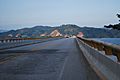
After flowing out of Nezahualcoyotl Lake, which was formed by the Malpaso Dam, the Grijalva River turns north and east. It flows through the city of Villahermosa, where a modern bridge was built over it in 2001. Finally, the river empties into the Gulf of Mexico, close to the town of Frontera.
River Basin and Connections
The area where all the water collects for the Grijalva River is huge, about 134,400 km2 (51,900 sq mi) (51,892 square miles). The Grijalva River is also closely connected to the Usumacinta River. These two rivers actually join together before flowing into the Gulf of Mexico. Because of this, they are often seen as one big river basin, called the Grijalva-Usumacinta River system.
Small boats can travel on the Grijalva River for about 100 mi (160 km) (160 km) upstream from its mouth. This makes it useful for transportation and local activities.
Dams and Hydroelectric Power
The Grijalva River is very important for generating electricity in Mexico. Several large hydroelectric dams have been built along its course. These dams use the power of the flowing water to create electricity.
- Angostura Dam: This dam creates a large reservoir, or artificial lake, which helps control the river's flow and store water.
- Malpaso Dam: This dam created Nezahualcoyotl Lake, another important artificial lake.
- Chicoasén Dam: The Chicoasén Dam is one of the tallest dams in the world and a major source of hydroelectric power for Mexico.
These dams are crucial for providing energy to homes and businesses, but they also change the natural flow of the river.
Gallery
-
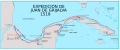
Juan de Grijalva's expedition in 1518, when Europeans first explored the Grijalva River.
-
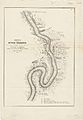
Sketch of the River Tabasco, drawn between 1847 and 1848.
-
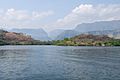
A view of the reservoir near Chicoasén.
-
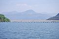
A close-up view of the Chicoasén Dam.
-
The Malpaso Dam, another important dam on the river.
-
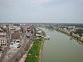
The Grijalva River flowing through the city of Villahermosa.
-
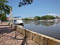
A scenic view of the Grijalva River in Villahermosa.
-
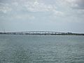
The mouth of the Grijalva River near Frontera.


See also
 In Spanish: Río Grijalva para niños
- Chiapas bridge
- List of longest rivers of Mexico
