
Sierra de los Cuchumatanes facts for kids
Quick facts for kids Sierra de los Cuchumatanes |
|
|---|---|
 |
|
| Highest point | |
| Peak | La Torre (Todos Santos Cuchumatán) |
| Elevation | 3,837 m (12,589 ft) |
| Dimensions | |
| Area | 16,350 km2 (6,310 sq mi) |
| Geography | |

Sierra de los Cuchumatanes
Location in Guatemala
|
|
| Country | Guatemala |
| Geology | |
| Age of rock | Paleozoic to Mesozoic |
| Type of rock | Karst and sedimentary rock |
The Sierra de los Cuchumatanes is the tallest non-volcanic mountain range in Central America. Its peaks range from about 500 meters (1,640 feet) to over 3,800 meters (12,467 feet) high. This huge area covers about 16,350 square kilometers (6,310 square miles). It's also the largest high-altitude region in Central America, with 1,500 square kilometers (580 square miles) of land above 3,000 meters (9,840 feet).
You can find the Sierra de los Cuchumatanes in western Guatemala. It stretches across the Huehuetenango and El Quiché areas. The Seleguá River forms its western and southwestern edges. This river separates the Cuchumatanes from the Sierra Madre volcanic mountains. To the south, the Río Negro marks its border. This river flows into the Chixoy River, which then turns north. It separates the Cuchumatanes from the mountains in the Alta Verapaz region. The very highest peaks, reaching up to 3,837 meters (12,589 feet), are found in the Huehuetenango area.
Contents
- What's in a Name? The Meaning of "Cuchumatán"
- Climate and Nature: Exploring the Cuchumatanes' Ecosystems
- How the Mountains Formed: A Look at Their History
- A Glimpse into the Past: Early Life in the Sierra
- Life and Work: The Economy of the Cuchumatanes
- Homes and Buildings: Changing Styles
- Images for kids
- See also
What's in a Name? The Meaning of "Cuchumatán"
The name "Cuchumatán" comes from the Mam words cuchuj and matán. Cuchuj means "to join" or "to unite," and matán means "with superior force." So, "Cuchumatán" can mean "that which was brought together by superior force." Another idea is that it comes from the Nahuatl word kochmatlán. This word means "place of the parrot hunters."
Climate and Nature: Exploring the Cuchumatanes' Ecosystems
The Cuchumatanes mountains have many different biomes, which are like natural zones with specific plants and animals.
- You can find pine-oak forests and humid mountain forests.
- Higher up, there are wet mountain forests and grassy, shrubby areas.
- In the northern foothills, there are subtropical rainforests.
Some experts believe that the plants in the Sierra de los Cuchumatanes are more like those in the Andes Mountains of South America. This is because of the high elevation and cool climate, which are different from most of Mesoamerica.
The area mostly has open grasslands called páramos. But you can also find groups of juniper and pines trees, along with forests of fir trees. In the past, sheep grazing changed the land. It caused soil erosion and reduced the number of trees because sheep ate the young seedlings. Today, many trees grow in places that are too steep for sheep to reach.
How the Mountains Formed: A Look at Their History
These mountains were formed a very long time ago, during the Cretaceous Period. The Altos de Chiantla is a flat, table-shaped land area within the Sierra.
A Glimpse into the Past: Early Life in the Sierra
Historians think that the Sierra and the Altos de Chiantla didn't have many people living there all the time before the Spanish arrived in Mesoamerica. It's possible that people planted potatoes, then left to live in nearby towns. They might have returned only when they needed to harvest the potatoes. Scientists are not sure if people in Mesoamerica grew potatoes in the Sierra before the Spanish came or if it started after.
However, after the Spanish conquest, the area began to be farmed much more intensely. Potato farming either started or became much more common, and sheep were brought to the region.
Life and Work: The Economy of the Cuchumatanes
People in the Sierra de los Cuchumatanes mostly grow potatoes and raise sheep. Unlike many other Mayan communities, they don't grow much maize (corn).
You can see hundreds of miles of stone fences in the Sierra. These fences are used to keep the sheep in certain areas. People often place small amounts of soil on top of these stone fences to grow plants like agave.
Many young people leave the Sierra to find jobs in other places. Some even travel to the United States. They often send remittances (money) back home to their families. Their families use this money to build new houses and buy pickup trucks. They also use it to install irrigation systems for farming and get electricity. The trucks have helped local people find better markets to sell their potatoes and wool.
Homes and Buildings: Changing Styles
Some people in the Sierra still live in traditional Mayan-style houses with thatched roofs made of grass. But because young people are sending money home, their families have been able to build houses using cinder blocks. These newer houses often have roofs made of corrugated metal, and most of them have two stories. One benefit of cinder block houses is that they have fewer rats than houses with grass roofs.
The traditional Mayan sweat bath is called a chuj. It's usually made of rock or adobe with a roof covered in live sod (grass and soil). With money sent home by young people, families have also started building new chuj out of cinder blocks.
Images for kids
-
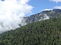
A view of the Sierra de los Cuchumatanes.
See also
 In Spanish: Sierra de los Cuchumatanes para niños
